TopoQuest Logo
Do you find TopoQuest useful?
Help keep TopoQuest running and adding new maps/features by donating!
Bitcoin:  19c7KJd3qBynnjoSw5npx9KScwjBe4ifkT
Litecoin:  LXs6TkuXGGXo1vDsWCkWVdjQX94eUKd6ui
Home View Maps Find Maps Find Places Resources & Links


Steam Mill, Georgia Topographic Map

USGS Map Title: Steam Mill, GA
USGS Map MRC: 30084H8
DRG (GeoTIFF) Download: o30084h8.tif


Neighboring USGS Topographic Map Quads:


  Saffold, GA  
31085A1
 

  Donalsonville West, GA  
31084A8
 

  Donalsonville East, GA  
31084A7
 

  Bascom, FL  
30085H1
 

  Steam Mill, GA  
30084H8
 

  Desser, GA  
30084H7
 

  Dellwood, FL  
30085G1
 

  Fairchild, GA  
30084G8
 

  Reynoldsville, GA  
30084G7


Map MRC Location:

N31°
W85°
N31°
W84°
H8 H7 H6 H5 H4 H3 H2 H1
G8 G7 G6 G5 G4 G3 G2 G1
F8 F7 F6 F5 F4 F3 F2 F1
E8 E7 E6 E5 E4 E3 E2 E1
D8 D7 D6 D5 D4 D3 D2 D1
C8 C7 C6 C5 C4 C3 C2 C1
B8 B7 B6 B5 B4 B3 B2 B1
A8 A7 A6 A5 A4 A3 A2 A1
N30°
W85°
N30°
W84°

Steam Mill, GA USGS 1:24K Topographic Map Preview:
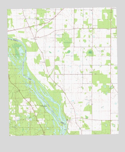
Steam Mill, GA USGS Topographic Map
Click on map above to begin viewing in our Map Viewer.

This topographic map contains these locations and features:
Feature Name Type Latitude Longitude GNIS ID View Map
Brunson CemeteryCemeteryN30.9537°W84.9294°311911View Map
Circle Hill ChurchChurchN30.8832°W84.9952°280462View Map
Danley CemeteryCemeteryN30.9981°W84.9034°313301View Map
Desser LandingLocaleN30.8891°W84.9346°342401View Map
Dickenson CemeteryCemeteryN30.9477°W84.9583°313466View Map
Green Acres SubdivisionPopulated PlaceN30.9894°W84.8799°342412View Map
Green Willow CemeteryCemeteryN30.9950°W84.9681°2767395View Map
Griselda SchoolSchoolN30.9480°W84.8827°314927View Map
Hammock SpringsSpringN30.9732°W84.9424°315070View Map
Hammock Springs ChurchChurchN30.9824°W84.9019°315071View Map
Hebrew ChurchChurchN30.9091°W84.9049°315293View Map
Holy Neck ChurchChurchN30.9010°W84.9258°342414View Map
Holy Neck SchoolSchoolN30.9007°W84.9258°315596View Map
Lela CourthouseBuildingN30.9791°W84.8813°316761View Map
Lewis PondLakeN30.9562°W84.9056°316788View Map
Macedonia ChurchChurchN30.9185°W84.9877°286256View Map
RiverturnPopulated PlaceN30.9899°W84.9474°326491View Map
Riverturn ChurchChurchN30.9938°W84.9416°321657View Map
Saint Johns ChurchChurchN30.9899°W84.9669°342424View Map
Saint Johns SchoolSchoolN30.9902°W84.9666°322132View Map
Saint Marys ChurchChurchN30.9174°W84.9371°322192View Map
Steam MillPopulated PlaceN30.9702°W84.9685°333122View Map
Steam Mill DivisionCivilN30.9326°W84.9202°1936557View Map
The HammocksSwampN30.9652°W84.9313°324045View Map
Trinity ChurchChurchN30.9799°W84.9027°324300View Map
Williams CemeteryCemeteryN30.9880°W84.9527°325326View Map

Note: Coordinates in the location and feature list above are referenced to NAD83 datum.


Copyright (C) 2008-2024 Ryan Niemi / Sunset Dynamics ... All Rights Reserved