TopoQuest Logo
Do you find TopoQuest useful?
Help keep TopoQuest running and adding new maps/features by donating!
Bitcoin:  19c7KJd3qBynnjoSw5npx9KScwjBe4ifkT
Litecoin:  LXs6TkuXGGXo1vDsWCkWVdjQX94eUKd6ui
Home View Maps Find Maps Find Places Resources & Links


Bascom, Florida Topographic Map

USGS Map Title: Bascom, FL
USGS Map MRC: 30085H1
DRG (GeoTIFF) Download: o30085h1.tif


Neighboring USGS Topographic Map Quads:


  Grangeburg, AL  
31085A2
 

  Saffold, GA  
31085A1
 

  Donalsonville West, GA  
31084A8
 

  Malone, FL  
30085H2
 

  Bascom, FL  
30085H1
 

  Steam Mill, GA  
30084H8
 

  Marianna, FL  
30085G2
 

  Dellwood, FL  
30085G1
 

  Fairchild, GA  
30084G8


Map MRC Location:

N31°
W86°
N31°
W85°
H8 H7 H6 H5 H4 H3 H2 H1
G8 G7 G6 G5 G4 G3 G2 G1
F8 F7 F6 F5 F4 F3 F2 F1
E8 E7 E6 E5 E4 E3 E2 E1
D8 D7 D6 D5 D4 D3 D2 D1
C8 C7 C6 C5 C4 C3 C2 C1
B8 B7 B6 B5 B4 B3 B2 B1
A8 A7 A6 A5 A4 A3 A2 A1
N30°
W86°
N30°
W85°

Bascom, FL USGS 1:24K Topographic Map Preview:
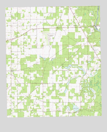
Bascom, FL USGS Topographic Map
Click on map above to begin viewing in our Map Viewer.

This topographic map contains these locations and features:
Feature Name Type Latitude Longitude GNIS ID View Map
BascomPopulated PlaceN30.9280°W85.1185°278143View Map
Bascom Lookout TowerTowerN30.9127°W85.0774°278145View Map
Bascom Post OfficePost OfficeN30.9288°W85.1189°2759155View Map
Bazzell CemeteryCemeteryN30.8810°W85.0288°278263View Map
Bazzell PondLakeN30.8845°W85.0343°289259View Map
Brenson PondLakeN30.9284°W85.0249°279357View Map
Buena VistaPopulated PlaceN30.8796°W85.0349°294702View Map
Cedar Grove ChurchChurchN30.9124°W85.0549°280191View Map
Cedar PondLakeN30.9313°W85.0429°280222View Map
Cedar Pond School (historical)SchoolN30.9341°W85.0377°280223View Map
Central SchoolSchoolN30.8813°W85.0110°280268View Map
Cow PondLakeN30.9410°W85.0630°280945View Map
Hickory Grove ChurchChurchN30.9821°W85.1105°283953View Map
HornsvillePopulated PlaceN30.9413°W85.0035°295359View Map
Irwin Mill CreekStreamN30.9849°W85.0049°120707View Map
Kings School (historical)SchoolN30.9321°W85.0183°285125View Map
Liberty Hill School (historical)SchoolN30.9452°W85.1102°285497View Map
Long PondLakeN30.9128°W85.0432°2771983View Map
LovedalePopulated PlaceN30.8799°W85.0430°295419View Map
McArthur PondLakeN30.9421°W85.0763°286563View Map
Mount Olive ChurchChurchN30.9755°W85.0888°287280View Map
Neals LandingPopulated PlaceN30.9774°W85.0052°332471View Map
North American Farms AirportAirportN30.9662°W85.0685°309638View Map
Post Oak ChurchChurchN30.9302°W85.1013°289257View Map
Shiloh ChurchChurchN30.9782°W85.0330°291043View Map
The FlatwoodsFlatN30.9094°W85.0094°292158View Map
Town of BascomCivilN30.9280°W85.1180°2405210View Map
Wolf PondLakeN30.8843°W85.0437°293468View Map

Note: Coordinates in the location and feature list above are referenced to NAD83 datum.


Copyright (C) 2008-2024 Ryan Niemi / Sunset Dynamics ... All Rights Reserved