TopoQuest Logo
Do you find TopoQuest useful?
Help keep TopoQuest running and adding new maps/features by donating!
Bitcoin:  19c7KJd3qBynnjoSw5npx9KScwjBe4ifkT
Litecoin:  LXs6TkuXGGXo1vDsWCkWVdjQX94eUKd6ui
Home View Maps Find Maps Find Places Resources & Links


Marianna, Florida Topographic Map

USGS Map Title: Marianna, FL
USGS Map MRC: 30085G2
DRG (GeoTIFF) Download: o30085g2.tif


Neighboring USGS Topographic Map Quads:


  Sills, FL  
30085H3
 

  Malone, FL  
30085H2
 

  Bascom, FL  
30085H1
 

  Cottondale East, FL  
30085G3
 

  Marianna, FL  
30085G2
 

  Dellwood, FL  
30085G1
 

  Kynesville, FL  
30085F3
 

  Oakdale, FL  
30085F2
 

  Cypress, FL  
30085F1


Map MRC Location:

N31°
W86°
N31°
W85°
H8 H7 H6 H5 H4 H3 H2 H1
G8 G7 G6 G5 G4 G3 G2 G1
F8 F7 F6 F5 F4 F3 F2 F1
E8 E7 E6 E5 E4 E3 E2 E1
D8 D7 D6 D5 D4 D3 D2 D1
C8 C7 C6 C5 C4 C3 C2 C1
B8 B7 B6 B5 B4 B3 B2 B1
A8 A7 A6 A5 A4 A3 A2 A1
N30°
W86°
N30°
W85°

Marianna, FL USGS 1:24K Topographic Map Preview:
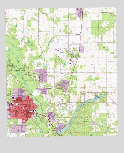
Marianna, FL USGS Topographic Map
Click on map above to begin viewing in our Map Viewer.

This topographic map contains these locations and features:
Feature Name Type Latitude Longitude GNIS ID View Map
Baltzell SpringSpringN30.8307°W85.2347°1828954View Map
Blue Hole SpringSpringN30.8202°W85.2452°279028View Map
Blue SpringSpringN30.7902°W85.1402°279069View Map
Buckhorn SchoolSchoolN30.8699°W85.2027°279606View Map
Carol PlazaLocaleN30.7821°W85.2449°295823View Map
Chipola Junior CollegeSchoolN30.8341°W85.1710°280402View Map
Chipola TerracePopulated PlaceN30.8274°W85.1658°295192View Map
City of MariannaCivilN30.7907°W85.2301°2405018View Map
County Training SchoolSchoolN30.7744°W85.2427°280896View Map
Dyke CemeteryCemeteryN30.7610°W85.2305°281907View Map
Federal Correctional Institution MariannaBuildingN30.8334°W85.1925°2753086View Map
Florida Caverns State ParkParkN30.8141°W85.2333°282602View Map
Frank M Golson Elementary SchoolSchoolN30.7852°W85.2413°298469View Map
Friendship ChurchChurchN30.7899°W85.1988°282830View Map
GreenwoodPopulated PlaceN30.8702°W85.1619°283427View Map
Greenwood ChapelChurchN30.8702°W85.1402°283437View Map
Greenwood Post OfficePost OfficeN30.8724°W85.1629°2759167View Map
Jackson CountyCivilN30.7954°W85.2155°295734View Map
Jackson County Adult Education DivisionSchoolN30.7802°W85.2391°298467View Map
Jackson County Fire and Rescue Unit Station 1BuildingN30.8237°W85.1703°2644626View Map
Jackson County Hospital HeliportAirportN30.7871°W85.2408°309647View Map
Jackson HospitalHospitalN30.7868°W85.2417°298705View Map
Lafayette PlazaLocaleN30.7816°W85.2427°295824View Map
Mallory HeightsPopulated PlaceN30.7613°W85.1888°308491View Map
MariannaPopulated PlaceN30.7744°W85.2269°286422View Map
Marianna Army Air Field (historical)MilitaryN30.8319°W85.1811°2092794View Map
Marianna DivisionCivilN30.7718°W85.2252°1935844View Map
Marianna Fire Department Station 15BuildingN30.7758°W85.2272°2644085View Map
Marianna High SchoolSchoolN30.7823°W85.2369°298468View Map
Marianna Middle SchoolSchoolN30.7681°W85.2489°298470View Map
Marianna Municipal AirportAirportN30.8378°W85.1819°309646View Map
Marianna Police DepartmentBuildingN30.7753°W85.2274°2754523View Map
Marianna Post OfficePost OfficeN30.7750°W85.2294°2759173View Map
Marianna Square Shopping CenterLocaleN30.7744°W85.2241°304196View Map
Merritts Mill PondReservoirN30.7790°W85.1667°286737View Map
Mordes AcademySchoolN30.7719°W85.2013°301539View Map
Mount Tabor SchoolSchoolN30.8327°W85.1360°287329View Map
Northwest Florida State HospitalHospitalN30.8274°W85.1727°287890View Map
Orange Hill CemeteryCemeteryN30.7721°W85.2438°288206View Map
Pebble Hill ChurchChurchN30.7582°W85.2419°288649View Map
Pinecrest Memorial GardensCemeteryN30.8113°W85.1874°298588View Map
Pope SchoolSchoolN30.7821°W85.1874°289197View Map
Poplar Spring CemeteryCemeteryN30.7641°W85.1588°289209View Map
Poplar Spring SchoolSchoolN30.7577°W85.1360°289211View Map
River Gate PlazaLocaleN30.7744°W85.2174°295822View Map
Riverside CemeteryCemeteryN30.7707°W85.2208°289741View Map
Riverside Elementary SchoolSchoolN30.7802°W85.2152°298466View Map
Roulhac CemeteryCemeteryN30.7560°W85.2355°289991View Map
Saint Mark ChurchChurchN30.7930°W85.2494°290281View Map
Sunland Hospital UnitHospitalN30.8348°W85.1770°298202View Map
Sunland Mariana Cox Medical Services CenterHospitalN30.7685°W85.2052°298704View Map
Town of GreenwoodCivilN30.8729°W85.1611°2406618View Map
Union Hill ChurchChurchN30.7921°W85.2460°292664View Map
WJNF-FM (Marianna)TowerN30.8035°W85.1966°309055View Map
WJNF-FM (Marianna)TowerN30.7730°W85.2288°309057View Map
WTYS-AM (Marianna)TowerN30.7638°W85.2310°308769View Map

Note: Coordinates in the location and feature list above are referenced to NAD83 datum.


Copyright (C) 2008-2024 Ryan Niemi / Sunset Dynamics ... All Rights Reserved