TopoQuest Logo
Do you find TopoQuest useful?
Help keep TopoQuest running and adding new maps/features by donating!
Bitcoin:  19c7KJd3qBynnjoSw5npx9KScwjBe4ifkT
Litecoin:  LXs6TkuXGGXo1vDsWCkWVdjQX94eUKd6ui
Home View Maps Find Maps Find Places Resources & Links


Fairchild, Georgia Topographic Map

USGS Map Title: Fairchild, GA
USGS Map MRC: 30084G8
DRG (GeoTIFF) Download: o30084g8.tif


Neighboring USGS Topographic Map Quads:


  Bascom, FL  
30085H1
 

  Steam Mill, GA  
30084H8
 

  Desser, GA  
30084H7
 

  Dellwood, FL  
30085G1
 

  Fairchild, GA  
30084G8
 

  Reynoldsville, GA  
30084G7
 

  Cypress, FL  
30085F1
 

  Sneads, FL  
30084F8
 

  Chattahoochee, FL  
30084F7


Map MRC Location:

N31°
W85°
N31°
W84°
H8 H7 H6 H5 H4 H3 H2 H1
G8 G7 G6 G5 G4 G3 G2 G1
F8 F7 F6 F5 F4 F3 F2 F1
E8 E7 E6 E5 E4 E3 E2 E1
D8 D7 D6 D5 D4 D3 D2 D1
C8 C7 C6 C5 C4 C3 C2 C1
B8 B7 B6 B5 B4 B3 B2 B1
A8 A7 A6 A5 A4 A3 A2 A1
N30°
W85°
N30°
W84°

Fairchild, GA USGS 1:24K Topographic Map Preview:
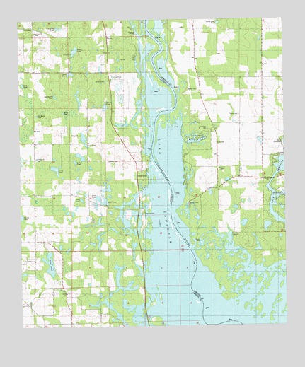
Fairchild, GA USGS Topographic Map
Click on map above to begin viewing in our Map Viewer.

This topographic map contains these locations and features:
Feature Name Type Latitude Longitude GNIS ID View Map
Apalachee Wildlife Management AreaParkN30.7744°W84.9671°300059View Map
Battle PondLakeN30.8375°W84.9791°278177View Map
Bellview ChurchChurchN30.8621°W84.9569°278466View Map
Boram LakeLakeN30.8626°W84.9736°279262View Map
Butler (historical)Populated PlaceN30.7980°W84.9435°300055View Map
Butlers Ferry (historical)CrossingN30.7955°W84.9288°342395View Map
Butlers Ferry LandingLocaleN30.8002°W84.9208°342396View Map
Buttonwood PondReservoirN30.8440°W84.9828°279755View Map
Charley PondReservoirN30.8720°W84.9816°280321View Map
Cummings LandingLocaleN30.7877°W84.9002°342400View Map
Drakes StillLocaleN30.8110°W84.9066°313617View Map
FairchildPopulated PlaceN30.8246°W84.9066°355752View Map
Fairchild CemeteryCemeteryN30.8310°W84.9110°314031View Map
Fairchild CemeteryCemeteryN30.8377°W84.9188°314032View Map
Fairchild LandingLocaleN30.8263°W84.9221°342405View Map
Fairchild School (historical)SchoolN30.8285°W84.8860°314034View Map
Fairchild State ParkParkN30.8266°W84.9166°342406View Map
Galilee ChurchChurchN30.8146°W84.9060°314485View Map
Half Moon PondLakeN30.8365°W84.9916°283600View Map
HaynesPopulated PlaceN30.8685°W84.9574°295341View Map
Heath PondReservoirN30.8397°W84.9592°283853View Map
Hettie PondLakeN30.8502°W84.9589°283930View Map
Jane PondReservoirN30.8242°W84.9685°284725View Map
Jones PondLakeN30.8143°W84.9830°284922View Map
Kit HoleLakeN30.8303°W84.9935°285149View Map
Little Zion School (historical)SchoolN30.7944°W84.9666°285859View Map
Mill PondLakeN30.8025°W84.9631°286897View Map
Moore PondLakeN30.7951°W84.9998°287111View Map
Nash PondReservoirN30.8017°W84.9710°287542View Map
Ned PondLakeN30.8519°W84.9553°287567View Map
Oak Grove ChurchChurchN30.8699°W84.9921°287953View Map
Paradise AcresPopulated PlaceN30.8191°W84.8799°342421View Map
ParramorePopulated PlaceN30.8721°W84.9930°294881View Map
Race PondLakeN30.7759°W84.9863°289425View Map
Robinson CemeteryCemeteryN30.7963°W84.9413°289797View Map
Rock PondLakeN30.8488°W84.9981°289849View Map
Salem ChurchChurchN30.7638°W84.9788°290417View Map
Sand LakeLakeN30.8025°W84.9653°290539View Map
Sand PondLakeN30.8535°W84.9755°290576View Map
Sand Ridge CemeteryCemeteryN30.8185°W84.9916°290582View Map
Sand Ridge ChurchChurchN30.8185°W84.9921°300057View Map
Seminole State ParkParkN30.8057°W84.8755°342432View Map
Simpsons CemeteryCemeteryN30.7524°W84.9963°300058View Map
Sylvania SchoolSchoolN30.8616°W84.9749°291984View Map
Tabernacle ChurchChurchN30.7519°W84.9780°291990View Map
Thompson Pond DitchStreamN30.7616°W84.9691°292229View Map
Tocktoethla (historical)Populated PlaceN30.8669°W84.9666°294486View Map
Trawick CemeteryCemeteryN30.8366°W84.9008°324278View Map
Turtle Shell PondLakeN30.8739°W84.9056°324428View Map
Wash PondLakeN30.8271°W84.9697°292906View Map
Whiddon CemeteryCemeteryN30.8177°W84.9580°293185View Map
Wooten CemeteryCemeteryN30.8463°W84.9199°325557View Map
Yarber PondReservoirN30.8173°W84.9738°293565View Map

Note: Coordinates in the location and feature list above are referenced to NAD83 datum.


Copyright (C) 2008-2024 Ryan Niemi / Sunset Dynamics ... All Rights Reserved