TopoQuest Logo
Do you find TopoQuest useful?
Help keep TopoQuest running and adding new maps/features by donating!
Bitcoin:  19c7KJd3qBynnjoSw5npx9KScwjBe4ifkT
Litecoin:  LXs6TkuXGGXo1vDsWCkWVdjQX94eUKd6ui
Home View Maps Find Maps Find Places Resources & Links


Donalsonville East, Georgia Topographic Map

USGS Map Title: Donalsonville East, GA
USGS Map MRC: 31084A7
DRG (GeoTIFF) Download: o31084a7.tif


Neighboring USGS Topographic Map Quads:


  Lucile, GA  
31084B8
 

  Donalsonville NE, GA  
31084B7
 

  Colquitt, GA  
31084B6
 

  Donalsonville West, GA  
31084A8
 

  Donalsonville East, GA  
31084A7
 

  Boykin, GA  
31084A6
 

  Steam Mill, GA  
30084H8
 

  Desser, GA  
30084H7
 

  Brinson, GA  
30084H6


Map MRC Location:

N32°
W85°
N32°
W84°
H8 H7 H6 H5 H4 H3 H2 H1
G8 G7 G6 G5 G4 G3 G2 G1
F8 F7 F6 F5 F4 F3 F2 F1
E8 E7 E6 E5 E4 E3 E2 E1
D8 D7 D6 D5 D4 D3 D2 D1
C8 C7 C6 C5 C4 C3 C2 C1
B8 B7 B6 B5 B4 B3 B2 B1
A8 A7 A6 A5 A4 A3 A2 A1
N31°
W85°
N31°
W84°

Donalsonville East, GA USGS 1:24K Topographic Map Preview:
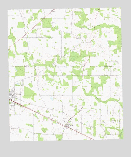
Donalsonville East, GA USGS Topographic Map
Click on map above to begin viewing in our Map Viewer.

This topographic map contains these locations and features:
Feature Name Type Latitude Longitude GNIS ID View Map
Antioch Free Will Baptist ChurchChurchN31.0449°W84.8730°342393View Map
Corinth ChurchChurchN31.0294°W84.8274°312980View Map
EnterprisePopulated PlaceN31.1230°W84.8258°355702View Map
Friendship CemeteryCemeteryN31.0430°W84.8680°314385View Map
Friendship Memorial GardensCemeteryN31.0448°W84.8684°314436View Map
Horns Cross Road (historical)Populated PlaceN31.1185°W84.8596°335164View Map
Indian Pond (historical)LakeN31.1249°W84.8688°335165View Map
Iron CityPopulated PlaceN31.0135°W84.8130°332064View Map
Iron City Baptist ChurchChurchN31.0149°W84.8091°342415View Map
Iron City Volunteer Fire DepartmentBuildingN31.0142°W84.8130°2604205View Map
Lane CemeteryCemeteryN31.1083°W84.7840°316614View Map
Miller CemeteryCemeteryN31.0070°W84.7702°335303View Map
Miller County Volunteer Fire Department Station 3 - Enterprize Volunteer Fire DepartmentBuildingN31.1202°W84.8262°2604202View Map
New Corinth ChurchChurchN31.0180°W84.7619°319298View Map
New Home CemeteryCemeteryN31.0980°W84.7946°335327View Map
New Home ChurchChurchN31.0971°W84.7958°319337View Map
Oak Long Missionary Baptist Church CemeteryCemeteryN31.0860°W84.8060°335332View Map
Pine Lake EstatesPopulated PlaceN31.0549°W84.8671°342422View Map
Pleasant Hill ChurchChurchN31.0413°W84.7585°320864View Map
Pleasant Hill ChurchChurchN31.0863°W84.8058°320866View Map
Red Hill ChurchChurchN31.0127°W84.7855°321381View Map
Seminole County Primary SchoolSchoolN31.0438°W84.8708°342430View Map
SharphagenPopulated PlaceN31.0207°W84.8288°333017View Map
Spooner (historical)Populated PlaceN31.0732°W84.8258°335183View Map
Town of Iron CityCivilN31.0136°W84.8133°2405894View Map
Twilight School (historical)SchoolN31.0932°W84.7860°335186View Map
Union ChurchChurchN31.1118°W84.8258°324506View Map
Union ChurchChurchN31.1166°W84.8358°324507View Map
Union Missionary Baptist Church CemeteryCemeteryN31.1174°W84.8360°335334View Map
Union Primitive Baptist Church CemeteryCemeteryN31.1118°W84.8255°335333View Map
Unity ChurchChurchN31.0607°W84.7633°324598View Map
Warrens Temple Church of God in ChristChurchN31.0455°W84.8730°342438View Map

Note: Coordinates in the location and feature list above are referenced to NAD83 datum.


Copyright (C) 2008-2024 Ryan Niemi / Sunset Dynamics ... All Rights Reserved