TopoQuest Logo
Do you find TopoQuest useful?
Help keep TopoQuest running and adding new maps/features by donating!
Bitcoin:  19c7KJd3qBynnjoSw5npx9KScwjBe4ifkT
Litecoin:  LXs6TkuXGGXo1vDsWCkWVdjQX94eUKd6ui
Home View Maps Find Maps Find Places Resources & Links


Ballplay, Alabama Topographic Map

USGS Map Title: Ballplay, AL
USGS Map MRC: 34085A7
DRG (GeoTIFF) Download: o34085a7.tif


Neighboring USGS Topographic Map Quads:


  Keener, AL  
34085B8
 

  Leesburg, AL  
34085B7
 

  Centre, AL  
34085B6
 

  Gadsden East, AL  
34085A8
 

  Ballplay, AL  
34085A7
 

  Weisner Mountain, AL  
34085A6
 

  Glencoe, AL  
33085H8
 

  Colvin Gap, AL  
33085H7
 

  Piedmont NW, AL  
33085H6


Map MRC Location:

N35°
W86°
N35°
W85°
H8 H7 H6 H5 H4 H3 H2 H1
G8 G7 G6 G5 G4 G3 G2 G1
F8 F7 F6 F5 F4 F3 F2 F1
E8 E7 E6 E5 E4 E3 E2 E1
D8 D7 D6 D5 D4 D3 D2 D1
C8 C7 C6 C5 C4 C3 C2 C1
B8 B7 B6 B5 B4 B3 B2 B1
A8 A7 A6 A5 A4 A3 A2 A1
N34°
W86°
N34°
W85°

Ballplay, AL USGS 1:24K Topographic Map Preview:
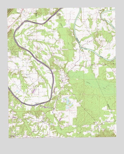
Ballplay, AL USGS Topographic Map
Click on map above to begin viewing in our Map Viewer.

This topographic map contains these locations and features:
Feature Name Type Latitude Longitude GNIS ID View Map
Adams FerryCrossingN34.0868°W85.7897°112927View Map
Advent ChurchChurchN34.0626°W85.8536°140425View Map
Antioch Methodist Church (historical)ChurchN34.0590°W85.8489°149016View Map
Bachelors ChapelPopulated PlaceN34.0195°W85.8700°149018View Map
Bachelors Chapel Baptist ChurchChurchN34.0201°W85.8702°157882View Map
Ball Play Volunteer Fire Department Station 1BuildingN34.0095°W85.7728°2683457View Map
Ball Play Volunteer Fire Department Station 2BuildingN34.0607°W85.8097°2683458View Map
BallplayPopulated PlaceN34.0587°W85.8080°113428View Map
Ballplay BendBendN34.1084°W85.8250°149019View Map
Ballplay Census Designated PlaceCensusN34.0179°W85.7852°2582662View Map
Ballplay CreekStreamN34.1201°W85.8177°159109View Map
Banner (historical)Populated PlaceN34.0084°W85.7764°166203View Map
Banner Post Office (historical)Post OfficeN34.0084°W85.7764°169233View Map
Baskin Ferry (historical)CrossingN34.0332°W85.8389°113550View Map
Birdsong School (historical)SchoolN34.0104°W85.7725°149023View Map
Coates Bend Volunteer Fire DepartmentBuildingN34.0840°W85.8717°2683008View Map
Coato Bend (historical)Populated PlaceN34.0529°W85.8458°140501View Map
Coats BendBendN34.0501°W85.8477°116318View Map
Coats Bend Census Designated PlaceCensusN34.0774°W85.8742°2582669View Map
Coats Bend School (historical)SchoolN34.0620°W85.8536°149042View Map
Croft CemeteryCemeteryN34.1120°W85.8658°164228View Map
Croft Ferry (historical)CrossingN34.1132°W85.8541°116877View Map
Dry CreekStreamN34.0326°W85.8380°117581View Map
Hale (historical)Populated PlaceN34.0929°W85.8272°140606View Map
Hokes Bluff DivisionCivilN34.0167°W85.8274°165770View Map
Hokes Bluff High SchoolSchoolN34.0140°W85.8700°140617View Map
Hollow Rock BranchStreamN34.0762°W85.8419°149064View Map
Jones Chapel Missionary Baptist ChurchChurchN34.0120°W85.7675°151913View Map
Kains School (historical)SchoolN34.0918°W85.8286°140632View Map
Lebanon CemeteryCemeteryN34.0665°W85.8672°149073View Map
Lebanon ChurchChurchN34.0665°W85.8664°121455View Map
Macedonia Missionary Baptist ChurchChurchN34.0615°W85.8539°122168View Map
Maple GrovePopulated PlaceN34.1204°W85.7694°155146View Map
Mayes CrossroadPopulated PlaceN34.0184°W85.8350°152253View Map
Mays School (historical)SchoolN34.0132°W85.8283°149079View Map
Mount Tabor CemeteryCemeteryN34.0854°W85.7964°123401View Map
Mount Tabor Missionary Baptist ChurchChurchN34.0851°W85.7958°149092View Map
Mount Tabor School (historical)SchoolN34.0848°W85.7972°149093View Map
Mount Zion ChurchChurchN34.0851°W85.8725°123486View Map
Mountain View CampLocaleN34.1226°W85.8500°140658View Map
Mountain View Fish CampLocaleN34.1140°W85.8525°164264View Map
MurrycrossPopulated PlaceN34.1207°W85.8586°156762View Map
New Bethel CemeteryCemeteryN34.0704°W85.7744°136949View Map
New Bethel CemeteryCemeteryN34.0073°W85.8444°1805301View Map
New Bethel ChurchChurchN34.0701°W85.7744°123722View Map
New Bethel Congregational Methodist ChurchChurchN34.0062°W85.8466°152606View Map
Oak Hill (historical)Populated PlaceN34.1118°W85.8605°140672View Map
Pollard BendBendN34.0929°W85.7677°125106View Map
Sims Chapel Primitive Baptist ChurchChurchN34.0951°W85.8500°126885View Map
Smith ChapelChurchN34.1043°W85.7694°127015View Map
Smith Chapel CemeteryCemeteryN34.1090°W85.7694°136984View Map
Sugar CreekStreamN34.0737°W85.7564°136987View Map
Thornton Number 1 LakeReservoirN34.0289°W85.8067°131895View Map
Thornton Number 2 LakeReservoirN34.0318°W85.8023°131896View Map
Thornton Number 3 LakeReservoirN34.0316°W85.8067°131901View Map
Thornton Number 4 LakeReservoirN34.0340°W85.8061°131907View Map
Thornton Number 5 LakeReservoirN34.0334°W85.8133°131903View Map
Thornton Number 6 LakeReservoirN34.0351°W85.8116°131908View Map
Thorton LakesReservoirN34.0290°W85.8083°127939View Map
Thorton Number 1 DamDamN34.0284°W85.8083°131894View Map
Thorton Number 2 DamDamN34.0301°W85.8033°131897View Map
Thorton Number 3 DamDamN34.0318°W85.8066°131900View Map
Thorton Number 4 DamDamN34.0351°W85.8050°131906View Map
Thorton Number 5 DamDamN34.0334°W85.8133°131902View Map
Thorton Number 6 DamDamN34.0351°W85.8116°131909View Map
Thorval DamDamN34.0451°W85.8650°131916View Map
Thorval LakeReservoirN34.0455°W85.8644°131917View Map
Turkeytown DivisionCivilN34.0643°W85.8637°165773View Map
Turkeytown Elementary SchoolSchoolN34.0837°W85.8716°165559View Map
Union Missionary Baptist ChurchChurchN34.0748°W85.8177°158097View Map
Wagners Store (historical)LocaleN34.0440°W85.8147°140757View Map
Wagnon Ferry (historical)CrossingN34.0648°W85.8250°128495View Map
Welcome Missionary Baptist ChurchChurchN34.0107°W85.7716°140768View Map
Wood Ferry (historical)CrossingN34.1157°W85.7652°137007View Map
Woods School (historical)SchoolN34.0590°W85.8086°149138View Map

Note: Coordinates in the location and feature list above are referenced to NAD83 datum.


Copyright (C) 2008-2024 Ryan Niemi / Sunset Dynamics ... All Rights Reserved