TopoQuest Logo
Do you find TopoQuest useful?
Help keep TopoQuest running and adding new maps/features by donating!
Bitcoin:  19c7KJd3qBynnjoSw5npx9KScwjBe4ifkT
Litecoin:  LXs6TkuXGGXo1vDsWCkWVdjQX94eUKd6ui
Home View Maps Find Maps Find Places Resources & Links


Centre, Alabama Topographic Map

USGS Map Title: Centre, AL
USGS Map MRC: 34085B6
DRG (GeoTIFF) Download: o34085b6.tif


Neighboring USGS Topographic Map Quads:


  Portersville, AL  
34085C7
 

  Little River, AL  
34085C6
 

  Gaylesville, AL  
34085C5
 

  Leesburg, AL  
34085B7
 

  Centre, AL  
34085B6
 

  Cedar Bluff, AL  
34085B5
 

  Ballplay, AL  
34085A7
 

  Weisner Mountain, AL  
34085A6
 

  Ellisville, AL  
34085A5


Map MRC Location:

N35°
W86°
N35°
W85°
H8 H7 H6 H5 H4 H3 H2 H1
G8 G7 G6 G5 G4 G3 G2 G1
F8 F7 F6 F5 F4 F3 F2 F1
E8 E7 E6 E5 E4 E3 E2 E1
D8 D7 D6 D5 D4 D3 D2 D1
C8 C7 C6 C5 C4 C3 C2 C1
B8 B7 B6 B5 B4 B3 B2 B1
A8 A7 A6 A5 A4 A3 A2 A1
N34°
W86°
N34°
W85°

Centre, AL USGS 1:24K Topographic Map Preview:
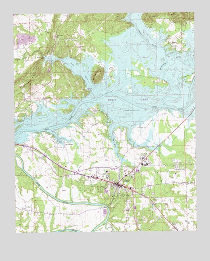
Centre, AL USGS Topographic Map
Click on map above to begin viewing in our Map Viewer.

This topographic map contains these locations and features:
Feature Name Type Latitude Longitude GNIS ID View Map
AndersonPopulated PlaceN34.1954°W85.7366°164493View Map
Anderson CoveBayN34.1951°W85.7327°136830View Map
AntiochPopulated PlaceN34.2306°W85.6380°113101View Map
Antioch EstatesPopulated PlaceN34.2459°W85.6430°136831View Map
Bay SpringsPopulated PlaceN34.1759°W85.7155°113592View Map
Bay Springs MarinaLocaleN34.1759°W85.7194°149775View Map
Bay View EstatesPopulated PlaceN34.2265°W85.7055°136837View Map
Big Nose CreekStreamN34.2015°W85.6900°114304View Map
Big Nose Creek SubdivisionPopulated PlaceN34.1709°W85.6777°136841View Map
Billy Goat HillPopulated PlaceN34.1943°W85.6950°114349View Map
Black Mallard CoveBayN34.2348°W85.6805°136842View Map
Blue PondPopulated PlaceN34.2370°W85.7202°156082View Map
Bothwell Methodist ChurchChurchN34.1404°W85.7430°155961View Map
Bradford Ferry (historical)CrossingN34.2107°W85.6550°136844View Map
Brooks EstatesPopulated PlaceN34.1362°W85.6727°136845View Map
Buffingtons IslandIslandN34.2120°W85.6277°136846View Map
Burkhalter SubdivisionPopulated PlaceN34.1820°W85.7180°136847View Map
CentrePopulated PlaceN34.1520°W85.6789°115902View Map
Centre CemeteryCemeteryN34.1495°W85.6752°136856View Map
Centre ChurchChurchN34.1584°W85.7077°136857View Map
Centre City HallBuildingN34.1515°W85.6758°149778View Map
Centre City ParkParkN34.1562°W85.6694°136858View Map
Centre Elementary SchoolSchoolN34.1501°W85.6702°136859View Map
Centre Middle SchoolSchoolN34.1509°W85.6769°136860View Map
Centre Municipal Airport (historical)AirportN34.1604°W85.6400°129491View Map
Centre Post OfficePost OfficeN34.1546°W85.6873°166613View Map
Centre Volunteer Fire DepartmentBuildingN34.1513°W85.6753°2682996View Map
Cherokee County CourthouseBuildingN34.1523°W85.6789°136862View Map
Cherokee County Health and Rehabilitation CenterBuildingN34.1664°W85.6614°136864View Map
Cherokee County High SchoolSchoolN34.1634°W85.6591°136863View Map
Cherokee County Sheriff's OfficeBuildingN34.1529°W85.6779°2751723View Map
Cherokee Medical CenterHospitalN34.1617°W85.6512°136833View Map
Cherokee Memory GardensCemeteryN34.1309°W85.6661°116003View Map
Cherokee Plaza Shopping CenterLocaleN34.1607°W85.6666°136866View Map
Chesnut CemeteryCemeteryN34.2065°W85.7008°136867View Map
Chestnut CoveBayN34.2001°W85.7116°136868View Map
City of CentreCivilN34.1554°W85.6708°2404025View Map
Coosa River SubdivisionPopulated PlaceN34.1362°W85.7055°136870View Map
Davis Fish FarmLocaleN34.1311°W85.7331°2674739View Map
Edwards Ferry (historical)CrossingN34.2015°W85.6908°136883View Map
ElrathPopulated PlaceN34.1382°W85.7430°156312View Map
Ethel Morrison Memorial ParkParkN34.1493°W85.6775°136885View Map
Ewing Ferry (historical)CrossingN34.2159°W85.6852°136886View Map
Fairview CemeteryCemeteryN34.1701°W85.7286°136887View Map
Fairview Methodist ChurchChurchN34.1701°W85.7291°118149View Map
First Baptist Church of CentreChurchN34.1515°W85.6764°155799View Map
Garrett BridgeBridgeN34.1393°W85.6869°118849View Map
Garrett CemeteryCemeteryN34.1381°W85.6850°136896View Map
Garrett Ferry (historical)CrossingN34.1390°W85.6869°136897View Map
Graveyard HillSummitN34.2087°W85.6841°136901View Map
GriffinPopulated PlaceN34.1932°W85.7416°136902View Map
Harris CemeteryCemeteryN34.2434°W85.6322°119798View Map
Hatcher High SchoolSchoolN34.1595°W85.6861°119842View Map
Hawthorn CoveBayN34.1932°W85.7194°136908View Map
Hog IslandIslandN34.2126°W85.6569°136910View Map
HopewellPopulated PlaceN34.2012°W85.7294°120355View Map
Kingdom Hall ChurchChurchN34.1354°W85.7044°136913View Map
Little RiverStreamN34.2248°W85.6450°150341View Map
Little River MarinaLocaleN34.2343°W85.6452°121863View Map
McGheePopulated PlaceN34.1679°W85.7325°122549View Map
Muddy BranchStreamN34.2348°W85.6880°136945View Map
Neal Hill CemeteryCemeteryN34.1431°W85.6541°123660View Map
Northwood EstatesPopulated PlaceN34.1632°W85.6319°136954View Map
Pine Grove Baptist ChurchChurchN34.1520°W85.6308°155899View Map
PineyPopulated PlaceN34.1520°W85.6264°124864View Map
Piney Grove CemeteryCemeteryN34.1520°W85.6319°136959View Map
Pratt CemeteryCemeteryN34.1568°W85.7152°136962View Map
RichardsonPopulated PlaceN34.2007°W85.7425°125604View Map
Roberts SubdivisionPopulated PlaceN34.1779°W85.7227°136967View Map
Round MountainPopulated PlaceN34.2157°W85.6839°125974View Map
Round MountainSummitN34.2159°W85.6905°125978View Map
Round Mountain Baptist ChurchChurchN34.2157°W85.6827°155801View Map
Round Mountain Ironworks (historical)LocaleN34.2140°W85.6819°136968View Map
Sand Valley Baptist ChurchChurchN34.1843°W85.6630°153319View Map
Sand Valley CemeteryCemeteryN34.1856°W85.6636°136974View Map
Sewell CemeteryCemeteryN34.1356°W85.7127°136976View Map
ShangrilaPopulated PlaceN34.2418°W85.6577°136980View Map
Shiloh Baptist ChurchChurchN34.1395°W85.7422°153427View Map
Shiloh CemeteryCemeteryN34.1401°W85.7427°136983View Map
Tates Chapel Baptist ChurchChurchN34.1862°W85.6939°153658View Map
Tates Chapel CemeteryCemeteryN34.1865°W85.6936°136989View Map
Terrapin CreekStreamN34.1307°W85.6877°160732View Map
Turkey Town (historical)Populated PlaceN34.1362°W85.6916°136995View Map
Union CemeteryCemeteryN34.2298°W85.7027°136996View Map
Union Methodist ChurchChurchN34.2293°W85.7027°153773View Map
WAGC-AM (Centre)TowerN34.1282°W85.6408°161054View Map
WEIS-AM (Centre)TowerN34.1529°W85.6789°161055View Map
Weiss DamPopulated PlaceN34.1745°W85.7416°137004View Map
Weiss LakeReservoirN34.2000°W85.6309°128714View Map
Westmoreland Ferry (historical)CrossingN34.2140°W85.6464°149782View Map
Windom Ball FieldParkN34.1582°W85.6691°137006View Map
Yellow CreekStreamN34.2015°W85.6936°150604View Map
Yellow Creek Baptist ChurchChurchN34.1898°W85.7480°154048View Map
Yellow Creek CemeteryCemeteryN34.1895°W85.7472°137009View Map
Yellow Creek FallsLocaleN34.2254°W85.7272°129291View Map
Yellow Creek View SubdivisionPopulated PlaceN34.2279°W85.7172°137010View Map

Note: Coordinates in the location and feature list above are referenced to NAD83 datum.


Copyright (C) 2008-2024 Ryan Niemi / Sunset Dynamics ... All Rights Reserved