TopoQuest Logo
Do you find TopoQuest useful?
Help keep TopoQuest running and adding new maps/features by donating!
Bitcoin:  19c7KJd3qBynnjoSw5npx9KScwjBe4ifkT
Litecoin:  LXs6TkuXGGXo1vDsWCkWVdjQX94eUKd6ui
Home View Maps Find Maps Find Places Resources & Links


Leesburg, Alabama Topographic Map

USGS Map Title: Leesburg, AL
USGS Map MRC: 34085B7
DRG (GeoTIFF) Download: o34085b7.tif


Neighboring USGS Topographic Map Quads:


  Crossville, AL  
34085C8
 

  Portersville, AL  
34085C7
 

  Little River, AL  
34085C6
 

  Keener, AL  
34085B8
 

  Leesburg, AL  
34085B7
 

  Centre, AL  
34085B6
 

  Gadsden East, AL  
34085A8
 

  Ballplay, AL  
34085A7
 

  Weisner Mountain, AL  
34085A6


Map MRC Location:

N35°
W86°
N35°
W85°
H8 H7 H6 H5 H4 H3 H2 H1
G8 G7 G6 G5 G4 G3 G2 G1
F8 F7 F6 F5 F4 F3 F2 F1
E8 E7 E6 E5 E4 E3 E2 E1
D8 D7 D6 D5 D4 D3 D2 D1
C8 C7 C6 C5 C4 C3 C2 C1
B8 B7 B6 B5 B4 B3 B2 B1
A8 A7 A6 A5 A4 A3 A2 A1
N34°
W86°
N34°
W85°

Leesburg, AL USGS 1:24K Topographic Map Preview:
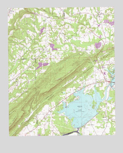
Leesburg, AL USGS Topographic Map
Click on map above to begin viewing in our Map Viewer.

This topographic map contains these locations and features:
Feature Name Type Latitude Longitude GNIS ID View Map
Antioch Church of ChristChurchN34.1784°W85.8655°113169View Map
Aubrey IslePopulated PlaceN34.1529°W85.7750°136832View Map
Bar HillSummitN34.1265°W85.8625°149020View Map
Beulah CemeteryCemeteryN34.1354°W85.8530°114175View Map
Big HollowValleyN34.2426°W85.8244°150106View Map
Big MountainRidgeN34.1398°W85.8694°114297View Map
BristowPopulated PlaceN34.1959°W85.7777°156114View Map
Bristow SpringSpringN34.1984°W85.7752°149261View Map
Buelah Baptist Church (historical)ChurchN34.1348°W85.8533°149032View Map
Byrams IslandIslandN34.1529°W85.8055°136848View Map
Calvery ChurchChurchN34.2451°W85.8744°158269View Map
Cedar Hill CemeteryCemeteryN34.1812°W85.7519°136854View Map
Cedar Hill Methodist ChurchChurchN34.1812°W85.7530°115801View Map
Davis Ferry (historical)CrossingN34.1259°W85.7911°117129View Map
Dixon ShopPopulated PlaceN34.1401°W85.7591°156274View Map
EwingPopulated PlaceN34.2026°W85.7644°156328View Map
Hamptons Ferry (historical)CrossingN34.1718°W85.7533°136905View Map
Helms LakeReservoirN34.1668°W85.8096°119939View Map
Huff GapGapN34.1732°W85.8430°120519View Map
Hunt ChapelChurchN34.2243°W85.8144°151821View Map
Hunts CemeteryCemeteryN34.2248°W85.8136°136912View Map
Jones BranchStreamN34.2345°W85.8030°150309View Map
Kings Hill (historical)Populated PlaceN34.1340°W85.8189°136914View Map
Lay SpringsPopulated PlaceN34.1684°W85.8566°156590View Map
LeesburgPopulated PlaceN34.1798°W85.7614°152019View Map
Leesburg DivisionCivilN34.2043°W85.7527°165688View Map
Leesburg Industrial ParkLocaleN34.1820°W85.7666°136920View Map
Leesburg ParkParkN34.1676°W85.7861°136921View Map
Leesburg Police DepartmentBuildingN34.1794°W85.7615°2752001View Map
Leesburg Post OfficePost OfficeN34.1766°W85.7600°166615View Map
Leesburg Volunteer Fire DepartmentBuildingN34.1794°W85.7617°2682723View Map
LeonardPopulated PlaceN34.2076°W85.8302°156601View Map
Liberty Church of ChristChurchN34.1998°W85.8450°121558View Map
Little Rock City ParkParkN34.1807°W85.8175°136922View Map
Livingston Junior High SchoolSchoolN34.1423°W85.7611°121927View Map
Lookout Valley AcresPopulated PlaceN34.1973°W85.7577°136923View Map
MackeyPopulated PlaceN34.1718°W85.7900°122179View Map
Mackey CemeteryCemeteryN34.1781°W85.7900°136928View Map
Missionary ChurchChurchN34.1357°W85.8066°1699999View Map
Mount Lookout CemeteryCemeteryN34.2445°W85.7919°123239View Map
Mountain Lake EstatesPopulated PlaceN34.1834°W85.7805°136943View Map
New Bethel CemeteryCemeteryN34.2376°W85.8311°136948View Map
New Bethel ChurchChurchN34.2370°W85.8322°123724View Map
Olivers Chapel Church of ChristChurchN34.2409°W85.8302°155896View Map
OwensPopulated PlaceN34.1295°W85.8502°156848View Map
Owl HollowValleyN34.1259°W85.8652°124358View Map
Pine Cove MarinaLocaleN34.1548°W85.8041°1700000View Map
Pine Grove CemeteryCemeteryN34.2187°W85.8483°150456View Map
Pine Grove ChurchChurchN34.2181°W85.8575°152920View Map
Pleasant Valley Baptist ChurchChurchN34.2093°W85.8344°153016View Map
Pleasant Valley CemeteryCemeteryN34.2084°W85.8339°136961View Map
Providence ChurchChurchN34.1351°W85.7786°125337View Map
Rock CityPillarN34.1804°W85.8180°125746View Map
Sand RockPopulated PlaceN34.2429°W85.7686°126330View Map
Sand Rock CemeteryCemeteryN34.2451°W85.7683°136971View Map
Sand Rock ChurchChurchN34.2468°W85.7683°136972View Map
Sand Rock High SchoolSchoolN34.2409°W85.7675°136973View Map
Sand Rock Volunteer Fire DepartmentBuildingN34.2386°W85.7675°2683071View Map
ScrougeoutPopulated PlaceN34.1809°W85.8691°157032View Map
Shady Grove Baptist ChurchChurchN34.1329°W85.7858°153394View Map
Shady Grove CemeteryCemeteryN34.1329°W85.7875°136979View Map
Shepard CemeteryCemeteryN34.1426°W85.8433°153406View Map
Shinbone ValleyValleyN34.1898°W85.7847°322908View Map
SlacklandPopulated PlaceN34.1468°W85.8300°126953View Map
Slackland Baptist ChurchChurchN34.1490°W85.8272°155921View Map
Tillery CoveBayN34.1620°W85.7716°149779View Map
Town of LeesburgCivilN34.1838°W85.7753°2405999View Map
Town of Sand RockCivilN34.2302°W85.7716°2407282View Map
Tripp Ferry (historical)CrossingN34.1690°W85.7689°136991View Map
Weiss DamDamN34.1721°W85.7538°128712View Map
Weiss Dam PowerhouseBuildingN34.1323°W85.7941°149780View Map
Weiss Lake DikeLeveeN34.1398°W85.7791°149781View Map

Note: Coordinates in the location and feature list above are referenced to NAD83 datum.


Copyright (C) 2008-2024 Ryan Niemi / Sunset Dynamics ... All Rights Reserved