TopoQuest Logo
Do you find TopoQuest useful?
Help keep TopoQuest running and adding new maps/features by donating!
Bitcoin:  19c7KJd3qBynnjoSw5npx9KScwjBe4ifkT
Litecoin:  LXs6TkuXGGXo1vDsWCkWVdjQX94eUKd6ui
Home View Maps Find Maps Find Places Resources & Links


Colvin Gap, Alabama Topographic Map

USGS Map Title: Colvin Gap, AL
USGS Map MRC: 33085H7
DRG (GeoTIFF) Download: o33085h7.tif


Neighboring USGS Topographic Map Quads:


  Gadsden East, AL  
34085A8
 

  Ballplay, AL  
34085A7
 

  Weisner Mountain, AL  
34085A6
 

  Glencoe, AL  
33085H8
 

  Colvin Gap, AL  
33085H7
 

  Piedmont NW, AL  
33085H6
 

  Wellington, AL  
33085G8
 

  Jacksonville West, AL  
33085G7
 

  Jacksonville East, AL  
33085G6


Map MRC Location:

N34°
W86°
N34°
W85°
H8 H7 H6 H5 H4 H3 H2 H1
G8 G7 G6 G5 G4 G3 G2 G1
F8 F7 F6 F5 F4 F3 F2 F1
E8 E7 E6 E5 E4 E3 E2 E1
D8 D7 D6 D5 D4 D3 D2 D1
C8 C7 C6 C5 C4 C3 C2 C1
B8 B7 B6 B5 B4 B3 B2 B1
A8 A7 A6 A5 A4 A3 A2 A1
N33°
W86°
N33°
W85°

Colvin Gap, AL USGS 1:24K Topographic Map Preview:
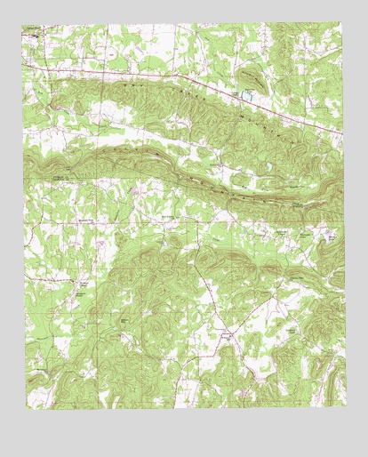
Colvin Gap, AL USGS Topographic Map
Click on map above to begin viewing in our Map Viewer.

This topographic map contains these locations and features:
Feature Name Type Latitude Longitude GNIS ID View Map
Adelia (historical)Populated PlaceN33.9112°W85.7777°166216View Map
Adelia Post Office (historical)Post OfficeN33.9112°W85.7777°169229View Map
Bennett DamDamN33.9768°W85.7900°131862View Map
Bennetts LakeReservoirN33.9762°W85.7876°113928View Map
Big Pine HillsRangeN33.8759°W85.8050°149164View Map
Bonner DamDamN33.9451°W85.8333°131848View Map
Bonners LakeReservoirN33.9462°W85.8320°131847View Map
City of Hokes BluffCivilN33.9902°W85.8639°2404710View Map
Coffee CreekStreamN33.9329°W85.8405°116351View Map
Colvin GapGapN33.9532°W85.8566°116463View Map
Colvin MountainRidgeN33.9487°W85.8086°159436View Map
Colvins GapPopulated PlaceN33.9362°W85.8133°140853View Map
Dry Creek MountainRidgeN33.9723°W85.8027°117600View Map
First Methodist ChurchChurchN33.9970°W85.8655°140557View Map
Ford School (historical)SchoolN33.9620°W85.8111°140562View Map
Ford Valley ChurchChurchN33.9537°W85.7975°118481View Map
Fords ValleyValleyN33.9668°W85.8597°149051View Map
Goodwin LakeReservoirN33.8997°W85.7693°119156View Map
Harrelson DamDamN33.9418°W85.7516°131841View Map
Harrelson LakeReservoirN33.9418°W85.7516°131842View Map
Hokes BluffPopulated PlaceN33.9982°W85.8664°155100View Map
Hokes Bluff Elementary SchoolSchoolN33.9965°W85.8702°140614View Map
Hokes Bluff Middle SchoolSchoolN33.9962°W85.8689°140618View Map
Hokes Bluff Police DepartmentBuildingN33.9922°W85.8656°2751804View Map
Hokes Bluff Volunteer Fire DepartmentBuildingN33.9921°W85.8656°2682740View Map
House of Prayer ChurchChurchN33.9968°W85.8730°140623View Map
Irene (historical)Populated PlaceN33.9390°W85.7958°166220View Map
Irene Post Office (historical)Post OfficeN33.9390°W85.7958°169271View Map
Johnson School (historical)SchoolN33.9676°W85.7655°149068View Map
Landers CemeteryCemeteryN33.9287°W85.8205°121365View Map
Landers School (historical)SchoolN33.9370°W85.8161°149192View Map
Mamre Baptist ChurchChurchN33.8787°W85.8539°140955View Map
McBride DamDamN33.9418°W85.7933°131844View Map
McBride LakeReservoirN33.9418°W85.7933°131843View Map
Midway Missionary Baptist ChurchChurchN33.9679°W85.7700°140649View Map
Millie (historical)Populated PlaceN33.9168°W85.8530°140964View Map
Mink (historical)Populated PlaceN33.8979°W85.7939°140965View Map
Mount Gilead (historical)Populated PlaceN33.8868°W85.8666°140967View Map
Mount Gilead Baptist ChurchChurchN33.8873°W85.8666°152418View Map
Mountain View ChurchChurchN33.9351°W85.8480°123533View Map
New Bethel Post Office (historical)Post OfficeN33.8787°W85.8091°166108View Map
New LibertyPopulated PlaceN33.9357°W85.8208°140982View Map
New Liberty Baptist ChurchChurchN33.9370°W85.8164°152657View Map
Ohatchee ChurchChurchN33.8987°W85.7944°140993View Map
Ohatchee Number 2 CemeteryCemeteryN33.8995°W85.7972°124188View Map
Overton DamDamN33.9312°W85.7591°131829View Map
Overton LakeReservoirN33.9302°W85.7567°124336View Map
Pattersons ChapelChurchN33.9307°W85.7744°124492View Map
Piedmont Highway ChurchChurchN33.9707°W85.7741°164203View Map
Pilgrims Rest ChurchChurchN33.9165°W85.7719°124744View Map
Pinegrove ChapelChurchN33.9123°W85.8552°124856View Map
Pleasant Valley SchoolSchoolN33.8848°W85.8166°149210View Map
ReavesPopulated PlaceN33.9751°W85.7902°140687View Map
Rock Spring GapGapN33.9445°W85.7947°141021View Map
Round MountainSummitN33.9826°W85.7858°125977View Map
Templeton DamDamN33.9334°W85.7616°131830View Map
Templeton PondReservoirN33.9334°W85.7616°131831View Map
Thompson LakeReservoirN33.9318°W85.7669°127910View Map
Webster ChapelPopulated PlaceN33.9170°W85.8552°153912View Map
Websters Chapel Junior High SchoolSchoolN33.9168°W85.8561°141068View Map
Websters Chapel Volunteer Fire DepartmentBuildingN33.9167°W85.8561°2682666View Map
Williams Junior High SchoolSchoolN33.8982°W85.7952°165588View Map
Wilson MountainSummitN33.9037°W85.8380°129089View Map
Youngs ChapelChurchN33.9759°W85.7914°154055View Map
Youngs Chapel CemeteryCemeteryN33.9759°W85.7908°1730397View Map

Note: Coordinates in the location and feature list above are referenced to NAD83 datum.


Copyright (C) 2008-2024 Ryan Niemi / Sunset Dynamics ... All Rights Reserved