TopoQuest Logo
Do you find TopoQuest useful?
Help keep TopoQuest running and adding new maps/features by donating!
Bitcoin:  19c7KJd3qBynnjoSw5npx9KScwjBe4ifkT
Litecoin:  LXs6TkuXGGXo1vDsWCkWVdjQX94eUKd6ui
Home View Maps Find Maps Find Places Resources & Links


Piedmont NW, Alabama Topographic Map

USGS Map Title: Piedmont NW, AL
USGS Map MRC: 33085H6
DRG (GeoTIFF) Download: o33085h6.tif


Neighboring USGS Topographic Map Quads:


  Ballplay, AL  
34085A7
 

  Weisner Mountain, AL  
34085A6
 

  Ellisville, AL  
34085A5
 

  Colvin Gap, AL  
33085H7
 

  Piedmont NW, AL  
33085H6
 

  Piedmont, AL  
33085H5
 

  Jacksonville West, AL  
33085G7
 

  Jacksonville East, AL  
33085G6
 

  Piedmont SE, AL  
33085G5


Map MRC Location:

N34°
W86°
N34°
W85°
H8 H7 H6 H5 H4 H3 H2 H1
G8 G7 G6 G5 G4 G3 G2 G1
F8 F7 F6 F5 F4 F3 F2 F1
E8 E7 E6 E5 E4 E3 E2 E1
D8 D7 D6 D5 D4 D3 D2 D1
C8 C7 C6 C5 C4 C3 C2 C1
B8 B7 B6 B5 B4 B3 B2 B1
A8 A7 A6 A5 A4 A3 A2 A1
N33°
W86°
N33°
W85°

Piedmont NW, AL USGS 1:24K Topographic Map Preview:
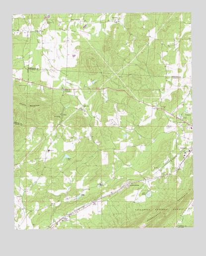
Piedmont NW, AL USGS Topographic Map
Click on map above to begin viewing in our Map Viewer.

This topographic map contains these locations and features:
Feature Name Type Latitude Longitude GNIS ID View Map
AllsopPopulated PlaceN33.9412°W85.7164°159062View Map
AsberryPopulated PlaceN33.8945°W85.7447°159088View Map
Asberry Baptist ChurchChurchN33.8879°W85.7430°162137View Map
Asberry Methodist Church (historical)ChurchN33.8876°W85.7427°162138View Map
Bald HornetSummitN33.9051°W85.6572°162837View Map
Big SpringSpringN33.9462°W85.7033°162895View Map
Big Willow SpringSpringN33.9573°W85.6875°162896View Map
Boozer DamDamN33.9187°W85.7137°161479View Map
Boozer LakeReservoirN33.9170°W85.7133°159234View Map
Browns School (historical)SchoolN33.9476°W85.6572°162146View Map
Cherry HillSummitN33.8929°W85.7322°162844View Map
Church of PrayerChurchN33.9584°W85.7411°159408View Map
Colliers SpringSpringN33.9532°W85.7122°162902View Map
Collins (historical)Populated PlaceN33.9565°W85.7069°162851View Map
Collins SpringSpringN33.9545°W85.7155°162903View Map
CouchPopulated PlaceN33.8932°W85.7125°162855View Map
Estes CrossroadsPopulated PlaceN33.9959°W85.7100°159579View Map
GnatvillePopulated PlaceN33.9954°W85.6761°159672View Map
Haven DamDamN33.8963°W85.6560°161476View Map
Hendon SpringSpringN33.9948°W85.6775°162892View Map
Hollis DamDamN33.8934°W85.7066°161475View Map
Hopewell SpringsSpringN33.9407°W85.7177°149188View Map
Kearney (historical)Populated PlaceN33.8854°W85.7083°166221View Map
Kearney Post Office (historical)Post OfficeN33.8854°W85.7083°169273View Map
Knightens ChapelChurchN33.9443°W85.7011°159902View Map
Knightens CrossroadsPopulated PlaceN33.9565°W85.7144°159903View Map
Knightens Crossroads Volunteer Fire Department Station 1BuildingN33.8861°W85.7431°2682658View Map
Knightens Crossroads Volunteer Fire Department Station 2BuildingN33.9533°W85.7149°2682977View Map
Lake HavenReservoirN33.8948°W85.6568°159738View Map
Lake HollisReservoirN33.8939°W85.7050°159792View Map
Lake WatsonReservoirN33.9290°W85.6719°161481View Map
Lebanon CemeteryCemeteryN33.9945°W85.7255°161876View Map
Lebanon Church of ChristChurchN33.9951°W85.7258°159920View Map
Littlejohn CemeteryCemeteryN33.9276°W85.7094°159993View Map
Living Water ChurchChurchN33.8982°W85.7258°162196View Map
MaxwellbornPopulated PlaceN33.8809°W85.7169°160063View Map
Maxwellborn SpringSpringN33.8762°W85.7230°162909View Map
Midway (historical)Populated PlaceN33.8909°W85.6847°162867View Map
Mill CreekStreamN33.9676°W85.7250°162869View Map
Millers Poultry Farm Number 1LocaleN33.9337°W85.6414°1805511View Map
Morehorn SpringSpringN33.9318°W85.7377°162910View Map
New Hopewell Baptist ChurchChurchN33.9404°W85.7175°160244View Map
Penny MountainSummitN33.9195°W85.7083°162876View Map
Piedmont DivisionCivilN33.9167°W85.6389°165678View Map
Piedmont SpringsPopulated PlaceN33.9004°W85.6711°160374View Map
Piedmont Springs Church CampLocaleN33.9009°W85.6939°162220View Map
Pioneer ChurchChurchN33.9084°W85.6369°160393View Map
Pisgah Baptist ChurchChurchN33.9948°W85.6769°160395View Map
Pisgah CemeteryCemeteryN33.9959°W85.6780°161877View Map
Plainview Congregational Holiness ChurchChurchN33.9032°W85.6714°160397View Map
PricesPopulated PlaceN33.8904°W85.6958°160446View Map
Rankins DamDamN33.9301°W85.6700°161480View Map
Roberts ChapelChurchN33.8809°W85.7161°160499View Map
Robertson SpringSpringN33.9576°W85.6855°162912View Map
Roy WebbPopulated PlaceN33.9204°W85.7272°162228View Map
Saddler MountainSummitN33.9315°W85.7339°162880View Map
Shady Grove Congregational Methodist ChurchChurchN33.9465°W85.7014°160584View Map
Sharon Hill Congregational Holiness ChurchChurchN33.9443°W85.6486°160591View Map
Taylors ChapelChurchN33.9904°W85.7322°160724View Map
Taylors Chapel CemeteryCemeteryN33.9895°W85.7316°161879View Map
The Apostle Doctrine ChurchChurchN33.9348°W85.6361°160736View Map
Webb SchoolSchoolN33.9209°W85.7255°160813View Map
Zuni (historical)Populated PlaceN33.8882°W85.7277°166229View Map
Zuni Post Office (historical)Post OfficeN33.8882°W85.7277°169319View Map
Zuni School (historical)SchoolN33.8759°W85.7269°162889View Map

Note: Coordinates in the location and feature list above are referenced to NAD83 datum.


Copyright (C) 2008-2024 Ryan Niemi / Sunset Dynamics ... All Rights Reserved