TopoQuest Logo
Do you find TopoQuest useful?
Help keep TopoQuest running and adding new maps/features by donating!
Bitcoin:  19c7KJd3qBynnjoSw5npx9KScwjBe4ifkT
Litecoin:  LXs6TkuXGGXo1vDsWCkWVdjQX94eUKd6ui
Home View Maps Find Maps Find Places Resources & Links


Searsport, Maine Topographic Map

USGS Map Title: Searsport, ME
USGS Map MRC: 44068D8
DRG (GeoTIFF) Download: o44068d8.tif


Neighboring USGS Topographic Map Quads:


  Brooks East, ME  
44069E1
 

  Mount Waldo, ME  
44068E8
 

  Bucksport, ME  
44068E7
 

  Belfast, ME  
44069D1
 

  Searsport, ME  
44068D8
 

  Castine, ME  
44068D7
 

  Lincolnville, ME  
44069C1
 

  Islesboro, ME  
44068C8
 

  Cape Rosier, ME  
44068C7


Map MRC Location:

N45°
W69°
N45°
W68°
H8 H7 H6 H5 H4 H3 H2 H1
G8 G7 G6 G5 G4 G3 G2 G1
F8 F7 F6 F5 F4 F3 F2 F1
E8 E7 E6 E5 E4 E3 E2 E1
D8 D7 D6 D5 D4 D3 D2 D1
C8 C7 C6 C5 C4 C3 C2 C1
B8 B7 B6 B5 B4 B3 B2 B1
A8 A7 A6 A5 A4 A3 A2 A1
N44°
W69°
N44°
W68°

Searsport, ME USGS 1:24K Topographic Map Preview:
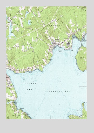
Searsport, ME USGS Topographic Map
Click on map above to begin viewing in our Map Viewer.

This topographic map contains these locations and features:
Feature Name Type Latitude Longitude GNIS ID View Map
BaysidePopulated PlaceN44.3798°W68.9686°561751View Map
Behind the Mill DamDamN44.4404°W68.9969°1774037View Map
Belfast BayBayN44.4117°W68.9659°562012View Map
Belfast Reservoir Number OneReservoirN44.3936°W68.9948°562013View Map
Bowditch CemeteryCemeteryN44.4736°W68.8863°562790View Map
Browns HeadCapeN44.3856°W68.9781°563074View Map
Bud Youngs DamDamN44.4310°W68.9931°1774583View Map
Cain PondLakeN44.4923°W68.9673°563339View Map
Carver Memorial LibraryBuildingN44.4606°W68.9226°2738479View Map
Central Maine DamDamN44.4404°W68.9969°1774585View Map
East Belfast CemeteryCemeteryN44.4278°W68.9861°565519View Map
East NorthportPopulated PlaceN44.3820°W68.9800°579279View Map
East Northport CemeteryCemeteryN44.3892°W68.9915°565645View Map
Edna Drinkwater SchoolSchoolN44.3831°W68.9787°565294View Map
Elmwood CemeteryCemeteryN44.4637°W68.9098°565878View Map
Ford ChapelChurchN44.4817°W68.9942°566375View Map
Goose RiverStreamN44.4298°W68.9928°566937View Map
Goose River ReservoirReservoirN44.4310°W68.9931°1774584View Map
Gordon CemeteryCemeteryN44.4416°W68.9416°566967View Map
Kidder PointCapeN44.4604°W68.8831°569153View Map
Little RiverStreamN44.3937°W68.9828°570014View Map
Little River Lower DamDamN44.3949°W68.9899°1774045View Map
Long CoveBayN44.4587°W68.8909°570193View Map
Long Cove BrookStreamN44.4684°W68.8973°570200View Map
Long Cove LedgeBarN44.4467°W68.9064°581809View Map
Mack PointCapeN44.4523°W68.9025°570628View Map
Marshall PointCapeN44.3781°W68.9025°581454View Map
Mason Pond DamDamN44.4433°W68.9996°1774039View Map
McClure PondLakeN44.4823°W68.9636°570955View Map
Mill BrookReservoirN44.4567°W68.9278°1774582View Map
Mill BrookStreamN44.4548°W68.9256°571310View Map
Mill Brook DamDamN44.4568°W68.9274°1774581View Map
Mill PondReservoirN44.4588°W68.9292°571341View Map
Moose PointCapeN44.4284°W68.9442°571612View Map
Moose Point State ParkParkN44.4395°W68.9478°571613View Map
Morrow BrookStreamN44.4309°W68.9525°571692View Map
Mosman ParkParkN44.4556°W68.9234°571724View Map
Mount Hope CemeteryCemeteryN44.4658°W68.9515°571768View Map
Northport Volunteer Fire Department Bluff StationBuildingN44.3759°W68.9673°2553210View Map
Patterson PointCapeN44.4265°W68.9867°573073View Map
Penobscot Marine Museum Stephen Phillips Research LibraryBuildingN44.4602°W68.9249°2738364View Map
Piper BrookStreamN44.4765°W68.9406°573440View Map
Sears IslandIslandN44.4431°W68.8775°581488View Map
Sears Island LedgeCliffN44.4292°W68.8895°578902View Map
Sears Island LedgeBarN44.4292°W68.8903°581896View Map
SearsportPopulated PlaceN44.4584°W68.9242°575131View Map
Searsport Census Designated PlaceCensusN44.4655°W68.9187°2377955View Map
Searsport District Middle School and High SchoolSchoolN44.4630°W68.9255°2738059View Map
Searsport District Middle School and High SchoolSchoolN44.4626°W68.9251°2737985View Map
Searsport Elementary SchoolSchoolN44.4641°W68.9257°2737984View Map
Searsport Fire Department South StationBuildingN44.4597°W68.9234°2552768View Map
Searsport HarborBayN44.4515°W68.9161°575132View Map
Searsport Police DepartmentBuildingN44.4597°W68.9235°2735900View Map
Searsport Post OfficePost OfficeN44.4574°W68.9257°2768954View Map
Smart CemeteryCemeteryN44.4851°W68.9950°575577View Map
Spragues BeachBeachN44.3784°W68.8839°576082View Map
Steels LedgeBarN44.4195°W68.9723°581922View Map
Town of SearsportCivilN44.4729°W68.9248°582716View Map
Turtle HeadCapeN44.3923°W68.8803°577449View Map
Turtle Head CoveBayN44.3817°W68.8886°577450View Map
Upper Mason PondReservoirN44.4660°W68.9981°577627View Map
Village CemeteryCemeteryN44.4631°W68.9317°580745View Map
Waldo County General HospitalHospitalN44.4125°W68.9941°2655124View Map
Waldo County General Hospital Marx LibraryBuildingN44.4128°W68.9943°2738355View Map

Note: Coordinates in the location and feature list above are referenced to NAD83 datum.


Copyright (C) 2008-2024 Ryan Niemi / Sunset Dynamics ... All Rights Reserved