TopoQuest Logo
Do you find TopoQuest useful?
Help keep TopoQuest running and adding new maps/features by donating!
Bitcoin:  19c7KJd3qBynnjoSw5npx9KScwjBe4ifkT
Litecoin:  LXs6TkuXGGXo1vDsWCkWVdjQX94eUKd6ui
Home View Maps Find Maps Find Places Resources & Links


Lincolnville, Maine Topographic Map

USGS Map Title: Lincolnville, ME
USGS Map MRC: 44069C1
DRG (GeoTIFF) Download: o44069c1.tif


Neighboring USGS Topographic Map Quads:


  Morrill, ME  
44069D2
 

  Belfast, ME  
44069D1
 

  Searsport, ME  
44068D8
 

  Searsmont, ME  
44069C2
 

  Lincolnville, ME  
44069C1
 

  Islesboro, ME  
44068C8
 

  West Rockport, ME  
44069B2
 

  Camden, ME  
44069B1
 

  North Haven West, ME  
44068B8


Map MRC Location:

N45°
W70°
N45°
W69°
H8 H7 H6 H5 H4 H3 H2 H1
G8 G7 G6 G5 G4 G3 G2 G1
F8 F7 F6 F5 F4 F3 F2 F1
E8 E7 E6 E5 E4 E3 E2 E1
D8 D7 D6 D5 D4 D3 D2 D1
C8 C7 C6 C5 C4 C3 C2 C1
B8 B7 B6 B5 B4 B3 B2 B1
A8 A7 A6 A5 A4 A3 A2 A1
N44°
W70°
N44°
W69°

Lincolnville, ME USGS 1:24K Topographic Map Preview:
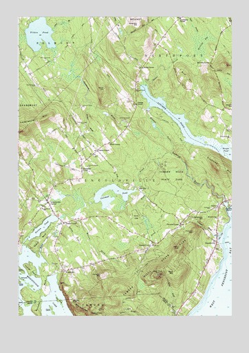
Lincolnville, ME USGS Topographic Map
Click on map above to begin viewing in our Map Viewer.

This topographic map contains these locations and features:
Feature Name Type Latitude Longitude GNIS ID View Map
Alder BrookStreamN44.3695°W69.1050°561133View Map
Bald Rock MountainSummitN44.2670°W69.0437°579945View Map
Battle Bridge BrookStreamN44.3740°W69.1136°561728View Map
Bayshore Union ChurchChurchN44.2909°W69.0084°561750View Map
Beach CemeteryCemeteryN44.2787°W69.0084°561757View Map
Bird HillSummitN44.3488°W69.0268°562363View Map
Black BrookStreamN44.3154°W69.0473°562388View Map
Camden Hills State ParkParkN44.2823°W69.0389°563375View Map
Cameron MountainSummitN44.2671°W69.0755°563380View Map
Carvers CornerPopulated PlaceN44.2884°W69.0300°579181View Map
Clarks CornerPopulated PlaceN44.3192°W69.0784°579197View Map
Coleman PondReservoirN44.2992°W69.0692°564219View Map
Coleman Pond DamDamN44.3031°W69.0571°1774318View Map
Collier CemeteryCemeteryN44.3331°W69.0128°564230View Map
Crane IslandIslandN44.2529°W69.1056°564491View Map
Derry MountainSummitN44.2779°W69.0308°565061View Map
Drake CornerPopulated PlaceN44.2890°W69.0981°579256View Map
DucktrapPopulated PlaceN44.2954°W69.0078°565369View Map
Ducktrap MountainSummitN44.3125°W69.0085°565371View Map
Ducktrap RiverStreamN44.2965°W69.0031°565372View Map
Fernalds NeckCapeN44.2515°W69.1136°566110View Map
Frohock BrookStreamN44.2834°W69.0078°566607View Map
Frohock MountainSummitN44.2853°W69.0222°566608View Map
Frohock PointCapeN44.2762°W69.0059°580556View Map
Garey MountainSummitN44.2690°W69.0359°566706View Map
Gould HillSummitN44.3451°W69.0746°566993View Map
Grange CornerPopulated PlaceN44.3384°W69.0556°579351View Map
Greenlaws CornerPopulated PlaceN44.3748°W69.0303°579366View Map
Griffin CemeteryCemeteryN44.2509°W69.0334°567331View Map
Heals CornerPopulated PlaceN44.3223°W69.0703°579398View Map
Heals NeckCapeN44.2815°W69.1123°567866View Map
Herricks BogSwampN44.3648°W69.0161°567969View Map
Herricks CornerPopulated PlaceN44.3554°W69.0128°579401View Map
Hills CemeteryCemeteryN44.3398°W69.0589°568062View Map
Hurds CornerPopulated PlaceN44.3537°W69.0520°579423View Map
Kelly IslandIslandN44.2695°W69.1239°569079View Map
Kendall BrookStreamN44.3184°W69.0359°569094View Map
Knight CemeteryCemeteryN44.3273°W69.0006°569241View Map
Knight PondLakeN44.3180°W69.0016°569247View Map
Levenseller MountainSummitN44.3287°W69.1233°569492View Map
LincolnvillePopulated PlaceN44.2812°W69.0086°569619View Map
Lincolnville CenterPopulated PlaceN44.2979°W69.1075°569620View Map
Lincolnville Center Post OfficePost OfficeN44.2939°W69.1125°2789360View Map
Lincolnville Central SchoolSchoolN44.2945°W69.1106°569621View Map
Lincolnville Fire DepartmentBuildingN44.2875°W69.1007°2552894View Map
Lincolnville Police DepartmentBuildingN44.2935°W69.1127°2735969View Map
Lincolnville Post OfficePost OfficeN44.2821°W69.0090°2768933View Map
Lincolnville Volunteer Fire Department Beach StationBuildingN44.2826°W69.0091°2553088View Map
Lower CemeteryCemeteryN44.2986°W69.1126°570479View Map
Maiden CliffCliffN44.2562°W69.0934°570666View Map
Maplewood CemeteryCemeteryN44.2951°W69.0114°570749View Map
Megunticook LakeLakeN44.2577°W69.1112°571129View Map
Millerite LedgesCliffN44.2529°W69.0881°571379View Map
Minnow BrookStreamN44.2948°W69.0889°571441View Map
Mount Megunticook TrailTrailN44.2506°W69.0823°1909545View Map
Mullin BogSwampN44.2812°W69.1092°571979View Map
Narrows IslandIslandN44.2651°W69.1223°572049View Map
Norton PondLakeN44.2873°W69.1102°572500View Map
Patterson HillSummitN44.3717°W69.0545°573072View Map
Pendleton HillSummitN44.2905°W69.0167°573155View Map
Pitcher CemeteryCemeteryN44.3478°W69.0498°573457View Map
Pitcher PondReservoirN44.3333°W69.0349°573459View Map
Pitcher Pond DamDamN44.3359°W69.0495°1774035View Map
Slab CityPopulated PlaceN44.3040°W69.0556°575537View Map
South Belmont CemeteryCemeteryN44.3467°W69.1139°575755View Map
Stevens CornerPopulated PlaceN44.2806°W69.0456°579742View Map
Sucker BrookStreamN44.3462°W69.0503°576477View Map
The FangIslandN44.2567°W69.1014°576797View Map
Tilden PondLakeN44.3677°W69.1124°577104View Map
Town of LincolnvilleCivilN44.2950°W69.0695°582561View Map
Townhouse CornerPopulated PlaceN44.3129°W69.0878°579774View Map
Tucker BrookStreamN44.3376°W69.0820°577384View Map
Union CemeteryCemeteryN44.3173°W69.0809°577539View Map
Upper CemeteryCemeteryN44.2987°W69.1170°577579View Map
Wiley NeckCapeN44.2642°W69.1239°578491View Map
Youngs NeckCapeN44.2690°W69.1173°578805View Map
YoungtownPopulated PlaceN44.2687°W69.0975°578810View Map
Youngtown Field (historical)AirportN44.2761°W69.0976°582175View Map
Zekes LookoutLocaleN44.2529°W69.0781°578814View Map

Note: Coordinates in the location and feature list above are referenced to NAD83 datum.


Copyright (C) 2008-2024 Ryan Niemi / Sunset Dynamics ... All Rights Reserved