TopoQuest Logo
Do you find TopoQuest useful?
Help keep TopoQuest running and adding new maps/features by donating!
Bitcoin:  19c7KJd3qBynnjoSw5npx9KScwjBe4ifkT
Litecoin:  LXs6TkuXGGXo1vDsWCkWVdjQX94eUKd6ui
Home View Maps Find Maps Find Places Resources & Links


Islesboro, Maine Topographic Map

USGS Map Title: Islesboro, ME
USGS Map MRC: 44068C8
DRG (GeoTIFF) Download: o44068c8.tif


Neighboring USGS Topographic Map Quads:


  Belfast, ME  
44069D1
 

  Searsport, ME  
44068D8
 

  Castine, ME  
44068D7
 

  Lincolnville, ME  
44069C1
 

  Islesboro, ME  
44068C8
 

  Cape Rosier, ME  
44068C7
 

  Camden, ME  
44069B1
 

  North Haven West, ME  
44068B8
 

  North Haven East, ME  
44068B7


Map MRC Location:

N45°
W69°
N45°
W68°
H8 H7 H6 H5 H4 H3 H2 H1
G8 G7 G6 G5 G4 G3 G2 G1
F8 F7 F6 F5 F4 F3 F2 F1
E8 E7 E6 E5 E4 E3 E2 E1
D8 D7 D6 D5 D4 D3 D2 D1
C8 C7 C6 C5 C4 C3 C2 C1
B8 B7 B6 B5 B4 B3 B2 B1
A8 A7 A6 A5 A4 A3 A2 A1
N44°
W69°
N44°
W68°

Islesboro, ME USGS 1:24K Topographic Map Preview:
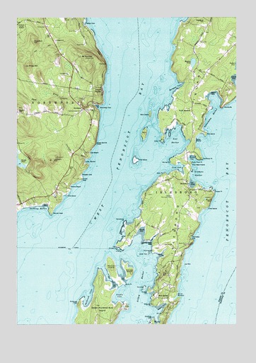
Islesboro, ME USGS Topographic Map
Click on map above to begin viewing in our Map Viewer.

This topographic map contains these locations and features:
Feature Name Type Latitude Longitude GNIS ID View Map
Abrams MountainSummitN44.3004°W68.8911°561070View Map
Alice L Pendleton LibraryBuildingN44.3031°W68.9013°2738421View Map
Ames CoveBayN44.2576°W68.9164°561232View Map
Barley LedgeBarN44.3501°W68.9170°581681View Map
Beech HillSummitN44.3381°W68.9984°561989View Map
Billys ShoreBeachN44.3251°W68.8975°562279View Map
Birch PointCapeN44.2665°W68.9381°562330View Map
Bobs PointCapeN44.3112°W68.9156°562638View Map
Bounty CoveBayN44.3176°W68.8998°562785View Map
Broad CoveBayN44.2884°W68.9281°562995View Map
Broad PointCapeN44.2840°W68.9259°563001View Map
Buring PointCapeN44.3165°W68.9120°563206View Map
Cals BeachBeachN44.3198°W68.9578°563364View Map
Charlottes CoveBayN44.2854°W68.8998°563862View Map
Coombs CoveBayN44.3495°W68.8750°564330View Map
Cradle CoveBayN44.2609°W68.9434°564445View Map
Crockett BranchStreamN44.3176°W68.9603°564531View Map
Crow CoveBayN44.3140°W68.9064°564589View Map
Crows NestPopulated PlaceN44.3090°W68.9628°579222View Map
Dark HarborBayN44.2612°W68.9086°564778View Map
Dark HarborPopulated PlaceN44.2606°W68.9136°564779View Map
Ducktrap HarborBayN44.2967°W68.9928°565370View Map
Durham State ForestForestN44.3734°W68.9975°565437View Map
Fire IslandCapeN44.3029°W68.9709°566159View Map
Fire IslandCapeN44.3279°W68.8920°566160View Map
Flat IslandIslandN44.3170°W68.9320°566284View Map
Gilkey HarborBayN44.2679°W68.9292°581427View Map
Gooseberry PointCapeN44.2915°W68.9378°566958View Map
Great Spruce HeadCliffN44.3242°W68.9542°567181View Map
Grindel PointCapeN44.2817°W68.9420°581431View Map
Haddock LedgeBarN44.2865°W68.9898°581762View Map
Hewes LedgeBenchN44.3084°W68.8870°578911View Map
Hewes LedgeBarN44.3084°W68.8861°581779View Map
Hewes PointCapeN44.3042°W68.8873°567988View Map
IslesboroPopulated PlaceN44.3084°W68.9034°568707View Map
Islesboro AirportAirportN44.3056°W68.9124°582163View Map
Islesboro Central SchoolSchoolN44.2679°W68.9185°563781View Map
Islesboro FerryLocaleN44.2812°W68.9773°568708View Map
Islesboro HarborBayN44.3101°W68.8989°568709View Map
Islesboro IslandIslandN44.3017°W68.9045°568710View Map
Islesboro Post OfficePost OfficeN44.2905°W68.9082°2768903View Map
Islesboro Volunteer Ambulance ServiceBuildingN44.2932°W68.9079°2666746View Map
Islesboro Volunteer Fire DepartmentBuildingN44.2931°W68.9080°2553036View Map
Jackson HillSummitN44.3170°W68.9795°568741View Map
Jobs MountainSummitN44.2828°W68.9021°568861View Map
Joes RockIslandN44.2745°W68.9048°568881View Map
Jones CoveBayN44.2784°W68.9170°568958View Map
Kedears HillSummitN44.3734°W68.8925°569053View Map
Keller PointCapeN44.3254°W68.9167°569066View Map
Kellys CoveBayN44.3723°W68.9603°569089View Map
Kissel PointCapeN44.2634°W68.9248°569225View Map
Knowlton HillSummitN44.3651°W68.9900°569263View Map
Little HarborBayN44.3165°W68.9600°569813View Map
Little IslandIslandN44.2970°W68.8914°569852View Map
Lobster RockSummitN44.2781°W68.9306°570143View Map
Long LedgeBarN44.2776°W68.9245°581811View Map
Long Ledge CoveBayN44.2834°W68.9231°570247View Map
Maple Grove CemeteryCemeteryN44.2827°W68.9027°570727View Map
Meadow PondLakeN44.3566°W68.8993°571098View Map
Mount PercivalSummitN44.3584°W68.9600°573192View Map
North IslesboroPopulated PlaceN44.3370°W68.8998°572351View Map
Northeast PointCapeN44.3179°W68.8942°572451View Map
NorthportPopulated PlaceN44.3379°W68.9614°572465View Map
Northport First RespondersBuildingN44.3372°W68.9635°2666790View Map
Northport Volunteer Fire DepartmentBuildingN44.3372°W68.9637°2553219View Map
Pebble BeachBeachN44.3062°W68.9692°573125View Map
Philbrook CoveBayN44.2598°W68.9598°573258View Map
Philbrook HeadSummitN44.2584°W68.9645°573259View Map
Priest HillSummitN44.3552°W68.9931°573810View Map
Ram IslandIslandN44.3356°W68.9234°574000View Map
Ruder CoveBayN44.3440°W68.8878°579999View Map
Sabbathday HarborBayN44.3351°W68.8903°574633View Map
Saturday CoveBayN44.3384°W68.9528°574931View Map
Saturday Cove CemeteryCemeteryN44.3371°W68.9625°574932View Map
Seal HarborBayN44.3245°W68.9092°575102View Map
Seal IslandIslandN44.3279°W68.9267°575109View Map
Seven Hundred Acre IslandIslandN44.2548°W68.9511°575238View Map
Shattuck PointCapeN44.2523°W68.9225°575315View Map
Shaw BrookStreamN44.3395°W68.9553°575318View Map
Sherman PointCapeN44.2798°W68.9220°575393View Map
Shipyard PointCapeN44.2584°W68.9225°575420View Map
Sprague CoveBayN44.3473°W68.9075°576074View Map
Sprague LedgeBarN44.3445°W68.9203°581920View Map
Spruce HeadCliffN44.2951°W68.9792°576133View Map
Spruce IslandIslandN44.2709°W68.9353°576137View Map
Temple HeightsPopulated PlaceN44.3454°W68.9503°576713View Map
The BluffCliffN44.3556°W68.9481°576760View Map
The BluffsCliffN44.3390°W68.8820°576762View Map
The GutGutN44.2681°W68.9461°576812View Map
The NarrowsGapN44.3145°W68.9017°576868View Map
Thorn Plum PointCapeN44.3159°W68.9006°577026View Map
ThrumcapIslandN44.2651°W68.9273°577071View Map
Town of IslesboroCivilN44.2979°W68.9181°582531View Map
Town of NorthportCivilN44.3487°W68.9869°582636View Map
Wales BeachBeachN44.2987°W68.9842°577783View Map
Warren IslandIslandN44.2726°W68.9453°577849View Map
Wrights CoveBayN44.3109°W68.9620°578718View Map

Note: Coordinates in the location and feature list above are referenced to NAD83 datum.


Copyright (C) 2008-2024 Ryan Niemi / Sunset Dynamics ... All Rights Reserved