TopoQuest Logo
Do you find TopoQuest useful?
Help keep TopoQuest running and adding new maps/features by donating!
Bitcoin:  19c7KJd3qBynnjoSw5npx9KScwjBe4ifkT
Litecoin:  LXs6TkuXGGXo1vDsWCkWVdjQX94eUKd6ui
Home View Maps Find Maps Find Places Resources & Links


Morgantown, Ohio Topographic Map

USGS Map Title: Morgantown, OH
USGS Map MRC: 39083B2
DRG (GeoTIFF) Download: o39083b2.tif


Neighboring USGS Topographic Map Quads:


  South Salem, OH  
39083C3
 

  Bourneville, OH  
39083C2
 

  Chillicothe West, OH  
39083C1
 

  Bainbridge, OH  
39083B3
 

  Morgantown, OH  
39083B2
 

  Summithill, OH  
39083B1
 

  Byington, OH  
39083A3
 

  Latham, OH  
39083A2
 

  Piketon, OH  
39083A1


Map MRC Location:

N40°
W84°
N40°
W83°
H8 H7 H6 H5 H4 H3 H2 H1
G8 G7 G6 G5 G4 G3 G2 G1
F8 F7 F6 F5 F4 F3 F2 F1
E8 E7 E6 E5 E4 E3 E2 E1
D8 D7 D6 D5 D4 D3 D2 D1
C8 C7 C6 C5 C4 C3 C2 C1
B8 B7 B6 B5 B4 B3 B2 B1
A8 A7 A6 A5 A4 A3 A2 A1
N39°
W84°
N39°
W83°

Morgantown, OH USGS 1:24K Topographic Map Preview:
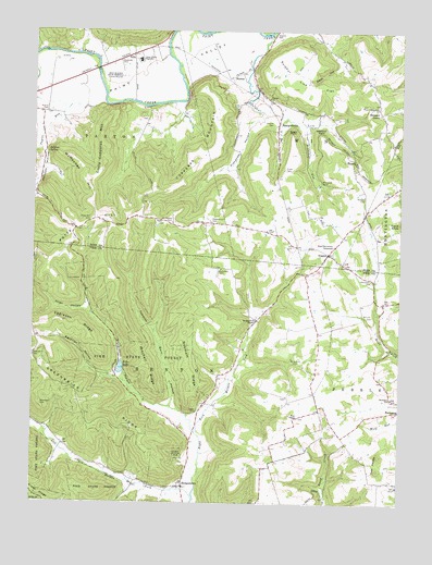
Morgantown, OH USGS Topographic Map
Click on map above to begin viewing in our Map Viewer.

This topographic map contains these locations and features:
Feature Name Type Latitude Longitude GNIS ID View Map
Alderman CemeteryCemeteryN39.1503°W83.2471°1037353View Map
Alexander HollowValleyN39.2256°W83.1771°1037360View Map
Allen HollowValleyN39.1756°W83.2324°1037366View Map
Barnett CemeteryCemeteryN39.1745°W83.1338°1037640View Map
Barnett School (historical)SchoolN39.1726°W83.1332°1055164View Map
Bond ChapelChurchN39.1476°W83.1591°1038185View Map
Bond Chapel CemeteryCemeteryN39.1478°W83.1588°1963397View Map
Buchanan SchoolSchoolN39.1528°W83.1268°1038443View Map
Christian Union Church LakeReservoirN39.1967°W83.1516°1077655View Map
Christian Union Church Lake DamDamN39.1967°W83.1516°1077654View Map
Coder School (historical)SchoolN39.2003°W83.2085°1050030View Map
Copperas MountainRidgeN39.2159°W83.1955°1066661View Map
DillsPopulated PlaceN39.2434°W83.2169°1039711View Map
Edger CemeteryCemeteryN39.1487°W83.1932°1040079View Map
Eggleson RidgeRidgeN39.1715°W83.2382°1040095View Map
Egyptian HollowValleyN39.1584°W83.2230°1061049View Map
Fels CemeteryCemeteryN39.1931°W83.1613°1040411View Map
Fowler HollowValleyN39.1381°W83.2413°1055182View Map
Garlands FordCrossingN39.1659°W83.1277°1063458View Map
Greenbrier CemeteryCemeteryN39.1637°W83.2496°1041119View Map
Greenbrier RidgeRidgeN39.1528°W83.1749°1063459View Map
Greenbrier School (historical)SchoolN39.1570°W83.2430°1055188View Map
HarrisPopulated PlaceN39.2156°W83.1410°1056314View Map
Jimtown HollowValleyN39.2187°W83.2471°1042100View Map
Left Fork Morgan ForkStreamN39.1259°W83.1941°1057791View Map
Little Copperas MountainSummitN39.2178°W83.2271°1042653View Map
Lookout PointCliffN39.2240°W83.1527°1042776View Map
McMechen HillSummitN39.2101°W83.2321°1057841View Map
Minnehan BendPopulated PlaceN39.2106°W83.1527°1065036View Map
Minnehan RunStreamN39.2251°W83.1585°1076408View Map
Mitchell RidgeRidgeN39.1615°W83.2119°1043417View Map
Morgan Fork ChapelChurchN39.1731°W83.1741°1043488View Map
MorgantownPopulated PlaceN39.1295°W83.1982°1065056View Map
Morgantown Post Office (historical)Post OfficeN39.1292°W83.1985°2044257View Map
Mount Auburn CemeteryCemeteryN39.1634°W83.1596°1043535View Map
Mount Carmel CemeteryCemeteryN39.1990°W83.2032°1043551View Map
Mount Holy ChurchChurchN39.1251°W83.1716°1043568View Map
Mount Victory School (historical)SchoolN39.1423°W83.1624°1055204View Map
NipgenPopulated PlaceN39.1912°W83.1494°1065157View Map
Nipgen Post Office (historical)Post OfficeN39.1917°W83.1499°2056658View Map
Paint Valley High SchoolSchoolN39.2420°W83.2146°1044279View Map
Pebble Township Volunteer Fire DepartmentBuildingN39.1528°W83.1269°2542431View Map
Pennisten CemeteryCemeteryN39.1837°W83.1343°1963424View Map
Pike LakeReservoirN39.1606°W83.2198°1070894View Map
Pike Lake DamDamN39.1601°W83.2182°1077961View Map
Platter CemeteryCemeteryN39.2284°W83.2461°1044522View Map
Pleasant GrovePopulated PlaceN39.2287°W83.1321°1056478View Map
Pleasant Hill CemeteryCemeteryN39.1995°W83.1896°1044540View Map
Ponslar School (historical)SchoolN39.1715°W83.2241°1055216View Map
Potts HillSummitN39.1973°W83.2355°1044725View Map
Potts Hill CemeteryCemeteryN39.1998°W83.2306°1044726View Map
Potts Hill School (historical)SchoolN39.2042°W83.2455°1050029View Map
Ralston School (historical)SchoolN39.1753°W83.1707°1055218View Map
Red School (historical)SchoolN39.2053°W83.1646°1050031View Map
Richardson HollowValleyN39.1456°W83.1963°1063467View Map
Right Fork Morgan ForkStreamN39.1259°W83.1941°1057956View Map
Roberts CemeteryCemeteryN39.2065°W83.1374°1045083View Map
Robinett RidgeRidgeN39.1731°W83.1955°1045094View Map
Ross-Pike County TabernacleChurchN39.1931°W83.1477°1045214View Map
Seip MoundSummitN39.2378°W83.2202°1063457View Map
Seip Mound State MemorialParkN39.2376°W83.2202°1075156View Map
Shoults CemeteryCemeteryN39.2490°W83.1681°1046246View Map
SpargursvillePopulated PlaceN39.2253°W83.1671°1065361View Map
Spargursville Post Office (historical)Post OfficeN39.2251°W83.1666°2056670View Map
Steep GapValleyN39.2412°W83.1469°1046666View Map
StormsPopulated PlaceN39.2387°W83.1802°1063038View Map
Storms CemeteryCemeteryN39.2253°W83.1694°1046743View Map
Storms ChurchChurchN39.2317°W83.1705°1046744View Map
Storms Post Office (historical)Post OfficeN39.2390°W83.1805°2043394View Map
Sugar PointCliffN39.2237°W83.1624°1046815View Map
Sulphur Lick FlatFlatN39.2390°W83.1607°1046853View Map
Sulphur Lick School (historical)SchoolN39.2376°W83.1757°1050032View Map
Summers CemeteryCemeteryN39.1870°W83.1869°1046857View Map
Taylor RunStreamN39.2303°W83.2266°1046969View Map
Tobacco Barn HollowValleyN39.1520°W83.2019°1067012View Map
Tong HollowValleyN39.2448°W83.2488°1047094View Map
Township of BentonCivilN39.1385°W83.2015°1086808View Map
Tuvell CemeteryCemeteryN39.2135°W83.1648°1047238View Map
Twin KnobsSummitN39.1334°W83.1316°1047244View Map
Wiper Memorial ChurchChurchN39.2301°W83.1332°1048017View Map

Note: Coordinates in the location and feature list above are referenced to NAD83 datum.


Copyright (C) 2008-2024 Ryan Niemi / Sunset Dynamics ... All Rights Reserved