TopoQuest Logo
Do you find TopoQuest useful?
Help keep TopoQuest running and adding new maps/features by donating!
Bitcoin:  19c7KJd3qBynnjoSw5npx9KScwjBe4ifkT
Litecoin:  LXs6TkuXGGXo1vDsWCkWVdjQX94eUKd6ui
Home View Maps Find Maps Find Places Resources & Links


Piketon, Ohio Topographic Map

USGS Map Title: Piketon, OH
USGS Map MRC: 39083A1
DRG (GeoTIFF) Download: o39083a1.tif


Neighboring USGS Topographic Map Quads:


  Morgantown, OH  
39083B2
 

  Summithill, OH  
39083B1
 

  Waverly North, OH  
39082B8
 

  Latham, OH  
39083A2
 

  Piketon, OH  
39083A1
 

  Waverly South, OH  
39082A8
 

  Rarden, OH  
38083H2
 

  Wakefield, OH  
38083H1
 

  Lucasville, OH  
38082H8


Map MRC Location:

N40°
W84°
N40°
W83°
H8 H7 H6 H5 H4 H3 H2 H1
G8 G7 G6 G5 G4 G3 G2 G1
F8 F7 F6 F5 F4 F3 F2 F1
E8 E7 E6 E5 E4 E3 E2 E1
D8 D7 D6 D5 D4 D3 D2 D1
C8 C7 C6 C5 C4 C3 C2 C1
B8 B7 B6 B5 B4 B3 B2 B1
A8 A7 A6 A5 A4 A3 A2 A1
N39°
W84°
N39°
W83°

Piketon, OH USGS 1:24K Topographic Map Preview:
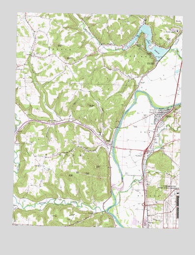
Piketon, OH USGS Topographic Map
Click on map above to begin viewing in our Map Viewer.

This topographic map contains these locations and features:
Feature Name Type Latitude Longitude GNIS ID View Map
Adena Pike Medical CenterHospitalN39.1165°W83.0039°1055209View Map
Bald KnobSummitN39.0317°W83.0755°1048482View Map
Barnes CemeteryCemeteryN39.0037°W83.0240°1963394View Map
Bell School (historical)SchoolN39.0040°W83.0810°1055167View Map
BethelPopulated PlaceN39.0095°W83.1238°1062648View Map
Bethel CemeteryCemeteryN39.0106°W83.1243°1963396View Map
Big Beaver CreekStreamN39.0131°W83.0471°1037998View Map
Boswell RunStreamN39.0809°W83.0335°1066597View Map
Brown CemeteryCemeteryN39.1006°W83.1102°1038368View Map
Calkins CemeteryCemeteryN39.0487°W83.0791°1038620View Map
Combs KnobSummitN39.1059°W83.0943°1048618View Map
Crooked CreekStreamN39.1062°W83.0085°1039485View Map
Daleville CemeteryCemeteryN39.1023°W83.0599°1039562View Map
Daley CemeteryCemeteryN39.0053°W83.0174°1039563View Map
DaleyvillePopulated PlaceN39.1067°W83.0538°1064502View Map
Daleyville Post Office (historical)Post OfficeN39.1070°W83.0541°2042457View Map
Dry RunStreamN39.0623°W83.0838°1039810View Map
Forest HillsPopulated PlaceN39.1092°W83.0099°1062769View Map
Gibson Trailer ParkPopulated PlaceN39.1192°W83.0308°2652047View Map
Grooms Mobile Home ParkPopulated PlaceN39.0478°W83.0597°2652048View Map
Hooper School (historical)SchoolN39.0148°W83.0755°1055191View Map
JasperPopulated PlaceN39.0501°W83.0566°1048399View Map
Jasper Elementary SchoolSchoolN39.0545°W83.0602°1081128View Map
Jasper KnobSummitN39.0359°W83.0632°1048869View Map
Jasper Methodist CemeteryCemeteryN39.0492°W83.0549°1963408View Map
Jasper Post OfficePost OfficeN39.0501°W83.0568°2042470View Map
Lake View HeightsPopulated PlaceN39.1073°W83.0305°1048897View Map
Lake WhiteReservoirN39.1048°W83.0254°1070992View Map
Lake White DamDamN39.1067°W83.0082°1078390View Map
Lake White Mobile Home ParkPopulated PlaceN39.1203°W83.0292°2652049View Map
Lake White State ParkParkN39.0976°W83.0196°1042387View Map
Little Beaver CreekStreamN39.0323°W83.0260°1042645View Map
Little Vine Primitive Baptist ChurchChurchN39.1017°W83.1127°1963412View Map
Long BranchStreamN39.1245°W83.0824°1042730View Map
Long ForkStreamN39.0490°W83.0580°1042738View Map
Long RidgeRidgeN39.0065°W83.0838°1042749View Map
Loys RunStreamN39.0106°W83.0630°1042818View Map
Milliron CemeteryCemeteryN39.0156°W83.0885°1043383View Map
Morkassel FieldAirportN39.1013°W83.1150°1082748View Map
Mound CemeteryCemeteryN39.0526°W83.0188°1963413View Map
No NameLocaleN39.0995°W83.1135°1043885View Map
No Name CreekStreamN39.0442°W83.0507°1057874View Map
Painters KnobSummitN39.0715°W83.0699°1063464View Map
Parmore CemeteryCemeteryN39.0490°W83.1107°1963423View Map
Pfeifer CemeteryCemeteryN39.1226°W83.0702°1963425View Map
Pike CountyCivilN39.0774°W83.0669°1074078View Map
Pike County FairgroundsLocaleN39.0612°W83.0143°1055208View Map
PiketonPopulated PlaceN39.0681°W83.0143°1061541View Map
Piketon Elementary SchoolSchoolN39.0676°W83.0124°1055211View Map
Piketon High SchoolSchoolN39.0667°W83.0177°1055212View Map
Piketon Historic DistrictParkN39.0681°W83.0135°1069729View Map
Piketon Post OfficePost OfficeN39.0687°W83.0138°2044273View Map
Piketon Post OficeBuildingN39.0678°W83.0143°1055213View Map
Piketon Seal Township Fire DepartmentBuildingN39.0699°W83.0115°2550147View Map
Piketon Trailer CourtPopulated PlaceN39.0644°W83.0267°2544741View Map
Pirates CovePopulated PlaceN39.1061°W83.0403°2544736View Map
Pleasant ValleyPopulated PlaceN39.0612°W83.0930°1062944View Map
Pleasant Valley CemeteryCemeteryN39.0603°W83.0966°1963426View Map
Poplar KnobSummitN39.0312°W83.0716°1063466View Map
R and J Mobile Home ParkPopulated PlaceN39.0458°W83.0719°2652050View Map
Red Bridge School (historical)SchoolN39.1209°W83.0288°1055219View Map
Rittenour CemeteryCemeteryN39.0678°W83.0205°1045036View Map
RiverdalePopulated PlaceN39.0087°W83.0630°1062980View Map
Riverdale Post Office (historical)Post OfficeN39.0084°W83.0624°2044263View Map
Riverview Mobile Home ParkPopulated PlaceN39.0692°W83.0189°2544738View Map
Riviera ParkPopulated PlaceN39.1020°W83.0230°1049124View Map
SargentsPopulated PlaceN39.0034°W83.0230°1049155View Map
Sargents Post Office (historical)Post OfficeN39.0028°W83.0235°2044264View Map
Skinner CemeteryCemeteryN39.0042°W83.0810°1046320View Map
Smokey HollowValleyN39.0584°W83.0980°1046390View Map
Sponyers KnobSummitN39.1062°W83.0943°1066973View Map
Stoney Ridge School (historical)SchoolN39.0623°W83.1121°1067179View Map
Stony Ridge (historical)Populated PlaceN39.0626°W83.1124°1067180View Map
Sugar RunStreamN39.0531°W83.0593°1046821View Map
Sunfish CreekStreamN39.0101°W83.0538°1066999View Map
Swiger KnobSummitN39.0303°W83.0846°1046904View Map
TennysonPopulated PlaceN39.0545°W83.1224°1063055View Map
Tennyson Post Office (historical)Post OfficeN39.0542°W83.1224°2044271View Map
Township of NewtonCivilN39.0412°W83.0908°1086813View Map
Township of Pee PeeCivilN39.1167°W83.0006°2574570View Map
United States Enrichment Corporation Fire StationBuildingN39.0135°W83.0248°2550351View Map
Van MeterPopulated PlaceN39.0423°W83.0268°1065428View Map
Vern Riffe Joint Vocational SchoolSchoolN39.0523°W83.0066°1055223View Map
Vine Chapel CemeteryCemeteryN39.1012°W83.1127°1963429View Map
Waldern Hill CemeteryCemeteryN39.0915°W83.1196°1047495View Map
Waverly GablesPopulated PlaceN39.1159°W83.0066°1063083View Map
Wintergreen RunStreamN39.1192°W83.0296°1048008View Map
Yankee HillRidgeN39.0395°W83.1110°1067070View Map
Yankee Hill CemeteryCemeteryN39.0353°W83.1049°1963433View Map
Yankee Hill ChurchChurchN39.0351°W83.1043°1048174View Map
Yankee Hill School (historical)SchoolN39.0406°W83.1005°1055232View Map

Note: Coordinates in the location and feature list above are referenced to NAD83 datum.


Copyright (C) 2008-2024 Ryan Niemi / Sunset Dynamics ... All Rights Reserved