TopoQuest Logo
Do you find TopoQuest useful?
Help keep TopoQuest running and adding new maps/features by donating!
Bitcoin:  19c7KJd3qBynnjoSw5npx9KScwjBe4ifkT
Litecoin:  LXs6TkuXGGXo1vDsWCkWVdjQX94eUKd6ui
Home View Maps Find Maps Find Places Resources & Links


Latham, Ohio Topographic Map

USGS Map Title: Latham, OH
USGS Map MRC: 39083A2
DRG (GeoTIFF) Download: o39083a2.tif


Neighboring USGS Topographic Map Quads:


  Bainbridge, OH  
39083B3
 

  Morgantown, OH  
39083B2
 

  Summithill, OH  
39083B1
 

  Byington, OH  
39083A3
 

  Latham, OH  
39083A2
 

  Piketon, OH  
39083A1
 

  Jaybird, OH  
38083H3
 

  Rarden, OH  
38083H2
 

  Wakefield, OH  
38083H1


Map MRC Location:

N40°
W84°
N40°
W83°
H8 H7 H6 H5 H4 H3 H2 H1
G8 G7 G6 G5 G4 G3 G2 G1
F8 F7 F6 F5 F4 F3 F2 F1
E8 E7 E6 E5 E4 E3 E2 E1
D8 D7 D6 D5 D4 D3 D2 D1
C8 C7 C6 C5 C4 C3 C2 C1
B8 B7 B6 B5 B4 B3 B2 B1
A8 A7 A6 A5 A4 A3 A2 A1
N39°
W84°
N39°
W83°

Latham, OH USGS 1:24K Topographic Map Preview:
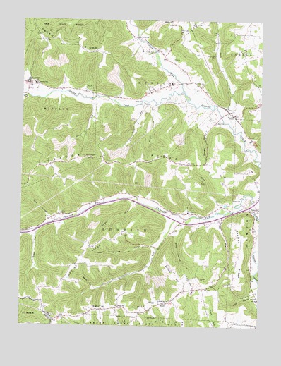
Latham, OH USGS Topographic Map
Click on map above to begin viewing in our Map Viewer.

This topographic map contains these locations and features:
Feature Name Type Latitude Longitude GNIS ID View Map
Abbott CemeteryCemeteryN39.0587°W83.1905°1037300View Map
Anderson School (historical)SchoolN39.0965°W83.1802°1055163View Map
ArkoePopulated PlaceN39.0445°W83.2324°1062633View Map
Arkoe CemeteryCemeteryN39.0459°W83.2288°1060829View Map
Arkoe Post Office (historical)Post OfficeN39.0445°W83.2319°2042450View Map
Barton CemeteryCemeteryN39.1148°W83.2271°1037660View Map
Beaver ChapelChurchN39.0687°W83.2141°1037747View Map
Beaver RidgeRidgeN39.0665°W83.2060°1060851View Map
Beeman RidgeRidgeN39.0295°W83.1346°1037812View Map
Benton Township Volunteer Fire DepartmentBuildingN39.1127°W83.1805°2550407View Map
Brewer CemeteryCemeteryN39.0517°W83.1368°1038288View Map
Brown School (historical)SchoolN39.0676°W83.2230°1055169View Map
Bull RunStreamN39.0462°W83.1463°1038511View Map
Camp RunStreamN39.0317°W83.1785°1070127View Map
Carter RunStreamN39.0456°W83.1677°1038849View Map
Chenoweth ForkStreamN39.0520°W83.1291°1079573View Map
Chestnut CemeteryCemeteryN39.0195°W83.1555°1039040View Map
Clayton Number 1 CemeteryCemeteryN39.1120°W83.1813°1039154View Map
Clayton Number 2 CemeteryCemeteryN39.1076°W83.1838°1039155View Map
Corner ChurchChurchN39.0078°W83.1980°1039377View Map
Crawford School (historical)SchoolN39.0645°W83.1543°1055175View Map
Elm GrovePopulated PlaceN39.0465°W83.1638°1064616View Map
Elm Grove Post OfficePost OfficeN39.0459°W83.1638°2043433View Map
Elm Grove Volunteer Fire Department Squad 5BuildingN39.0471°W83.1625°2550408View Map
Gardner CemeteryCemeteryN39.1092°W83.1713°1040760View Map
Georges RunStreamN39.0520°W83.1913°1040822View Map
Goat HollowValleyN39.0451°W83.2357°1040929View Map
Grassy ForkStreamN39.0945°W83.2477°1041064View Map
Green RidgeRidgeN39.1173°W83.2310°1041111View Map
Green Ridge School (historical)SchoolN39.1109°W83.2216°1055187View Map
Greer HollowValleyN39.0367°W83.1682°1041174View Map
HatchPopulated PlaceN39.0090°W83.1763°1062806View Map
Hatch Post Office (historical)Post OfficeN39.0084°W83.1763°2042460View Map
Henry CemeteryCemeteryN39.0395°W83.1693°1041492View Map
Hungry HollowValleyN39.0809°W83.1530°1041875View Map
IdahoPopulated PlaceN39.0881°W83.1418°1041911View Map
Idaho Post Office (historical)Post OfficeN39.0876°W83.1416°2042462View Map
Idaho School (historical)SchoolN39.0866°W83.1387°2463333View Map
Jabe Grooms HollowValleyN39.0320°W83.1810°1042015View Map
LathamPopulated PlaceN39.0990°W83.2466°1042426View Map
Latham Post OfficePost OfficeN39.0987°W83.2471°2042471View Map
Laurel RidgeRidgeN39.0320°W83.2149°1042432View Map
Laurel Ridge School (historical)SchoolN39.0320°W83.2132°1055194View Map
Leeth CreekStreamN39.0826°W83.1405°1042479View Map
Leeth Creek CemeteryCemeteryN39.1114°W83.1493°1042480View Map
Leeth Creek School (historical)SchoolN39.1217°W83.1488°1055195View Map
Lick RunStreamN39.0915°W83.1866°1042533View Map
Long RunStreamN39.0423°W83.2330°1055197View Map
Long RunStreamN39.0390°W83.2402°1042750View Map
Morgan ForkStreamN39.0951°W83.1646°1067082View Map
Mustard CemeteryCemeteryN39.0587°W83.1530°1043748View Map
Myers HollowValleyN39.0156°W83.2116°1043760View Map
Old Clay CemeteryCemeteryN39.0998°W83.1571°1044097View Map
Old Smith CemeteryCemeteryN39.0098°W83.1785°1044135View Map
Parker Elementary SchoolSchoolN39.0995°W83.1713°1081749View Map
Pennisten ChapelChurchN39.0865°W83.1382°1044370View Map
Red BridgeBridgeN39.0920°W83.1863°1044893View Map
Ross HollowValleyN39.0142°W83.1282°1045206View Map
Russell Number 1 CemeteryCemeteryN39.0842°W83.1471°1045294View Map
Shanks CemeteryCemeteryN39.0970°W83.2143°1046131View Map
Smith ChapelChurchN39.0956°W83.2132°1046373View Map
Smith HillSummitN39.0037°W83.2132°1046380View Map
Smith Hill CemeteryCemeteryN39.0095°W83.1741°1963427View Map
Smith Hill ChurchChurchN39.0098°W83.1738°1046381View Map
Spicy RunStreamN39.0926°W83.2144°1046529View Map
Spoon RiverStreamN39.0476°W83.1405°1046536View Map
Township of SunfishCivilN39.0375°W83.2039°1086819View Map
Victory HillSummitN39.0176°W83.1649°1047453View Map
Victory School (historical)SchoolN39.0195°W83.1455°1055224View Map
Ware CemeteryCemeteryN39.0773°W83.1293°1963430View Map
West McBee CemeteryCemeteryN39.1206°W83.1630°1047781View Map
Western High SchoolSchoolN39.0987°W83.2430°1055231View Map
Wilson BridgeBridgeN39.1181°W83.1891°1047972View Map
Wycoff HollowValleyN39.0890°W83.1813°1048164View Map

Note: Coordinates in the location and feature list above are referenced to NAD83 datum.


Copyright (C) 2008-2024 Ryan Niemi / Sunset Dynamics ... All Rights Reserved