TopoQuest Logo
Do you find TopoQuest useful?
Help keep TopoQuest running and adding new maps/features by donating!
Bitcoin:  19c7KJd3qBynnjoSw5npx9KScwjBe4ifkT
Litecoin:  LXs6TkuXGGXo1vDsWCkWVdjQX94eUKd6ui
Home View Maps Find Maps Find Places Resources & Links


Church Hill, Georgia Topographic Map

USGS Map Title: Church Hill, GA
USGS Map MRC: 32084B5
DRG (GeoTIFF) Download: o32084b5.tif


Neighboring USGS Topographic Map Quads:


  Glen Alta, GA  
32084C6
 

  Buena Vista, GA  
32084C5
 

  Tazewell South, GA  
32084C4
 

  Brooklyn, GA  
32084B6
 

  Church Hill, GA  
32084B5
 

  Draneville, GA  
32084B4
 

  Richland, GA  
32084A6
 

  Preston, GA  
32084A5
 

  Plains, GA  
32084A4


Map MRC Location:

N33°
W85°
N33°
W84°
H8 H7 H6 H5 H4 H3 H2 H1
G8 G7 G6 G5 G4 G3 G2 G1
F8 F7 F6 F5 F4 F3 F2 F1
E8 E7 E6 E5 E4 E3 E2 E1
D8 D7 D6 D5 D4 D3 D2 D1
C8 C7 C6 C5 C4 C3 C2 C1
B8 B7 B6 B5 B4 B3 B2 B1
A8 A7 A6 A5 A4 A3 A2 A1
N32°
W85°
N32°
W84°

Church Hill, GA USGS 1:24K Topographic Map Preview:
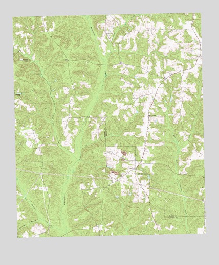
Church Hill, GA USGS Topographic Map
Click on map above to begin viewing in our Map Viewer.

This topographic map contains these locations and features:
Feature Name Type Latitude Longitude GNIS ID View Map
Antioch Baptist ChurchChurchN32.1757°W84.6099°354337View Map
Christmas BranchStreamN32.1352°W84.6077°312662View Map
Church HillPopulated PlaceN32.1632°W84.5455°331400View Map
Dry CreekStreamN32.1679°W84.5838°313667View Map
Evans ChapelChurchN32.1599°W84.5549°355730View Map
Flanigans PondReservoirN32.2066°W84.6214°355817View Map
Golden CreekStreamN32.1732°W84.5163°314672View Map
Hoggs (historical)Populated PlaceN32.1921°W84.5891°344103View Map
Lanahassee CreekStreamN32.2238°W84.5646°310346View Map
New Friendship ChurchChurchN32.1921°W84.5360°319319View Map
Old Union CemeteryCemeteryN32.2163°W84.5224°320033View Map
Shiloh CemeteryCemeteryN32.1596°W84.5452°344119View Map
Shiloh-Marion-Church Hill ChurchChurchN32.1602°W84.5444°322905View Map
Simmons LakeReservoirN32.1640°W84.5629°340741View Map
Simmons Lake DamDamN32.1652°W84.5633°340740View Map
Slaughter CreekStreamN32.1279°W84.5921°323077View Map
Smyrna CemeteryCemeteryN32.1629°W84.5455°344120View Map
Union ChurchChurchN32.2254°W84.5010°324518View Map
Weaver LakeReservoirN32.2468°W84.5483°341472View Map
Weaver Lake DamDamN32.2468°W84.5483°341471View Map

Note: Coordinates in the location and feature list above are referenced to NAD83 datum.


Copyright (C) 2008-2024 Ryan Niemi / Sunset Dynamics ... All Rights Reserved