TopoQuest Logo
Do you find TopoQuest useful?
Help keep TopoQuest running and adding new maps/features by donating!
Bitcoin:  19c7KJd3qBynnjoSw5npx9KScwjBe4ifkT
Litecoin:  LXs6TkuXGGXo1vDsWCkWVdjQX94eUKd6ui
Home View Maps Find Maps Find Places Resources & Links


Preston, Georgia Topographic Map

USGS Map Title: Preston, GA
USGS Map MRC: 32084A5
DRG (GeoTIFF) Download: o32084a5.tif


Neighboring USGS Topographic Map Quads:


  Brooklyn, GA  
32084B6
 

  Church Hill, GA  
32084B5
 

  Draneville, GA  
32084B4
 

  Richland, GA  
32084A6
 

  Preston, GA  
32084A5
 

  Plains, GA  
32084A4
 

  Benevolence, GA  
31084H6
 

  Parrott, GA  
31084H5
 

  Bottsford, GA  
31084H4


Map MRC Location:

N33°
W85°
N33°
W84°
H8 H7 H6 H5 H4 H3 H2 H1
G8 G7 G6 G5 G4 G3 G2 G1
F8 F7 F6 F5 F4 F3 F2 F1
E8 E7 E6 E5 E4 E3 E2 E1
D8 D7 D6 D5 D4 D3 D2 D1
C8 C7 C6 C5 C4 C3 C2 C1
B8 B7 B6 B5 B4 B3 B2 B1
A8 A7 A6 A5 A4 A3 A2 A1
N32°
W85°
N32°
W84°

Preston, GA USGS 1:24K Topographic Map Preview:
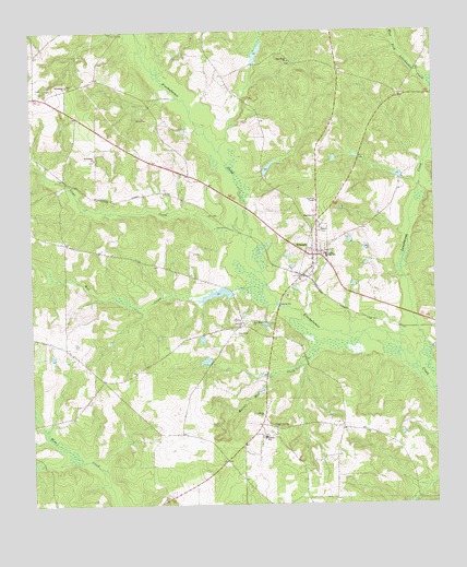
Preston, GA USGS Topographic Map
Click on map above to begin viewing in our Map Viewer.

This topographic map contains these locations and features:
Feature Name Type Latitude Longitude GNIS ID View Map
Askew CemeteryCemeteryN32.0263°W84.6096°345023View Map
Bankston LakeReservoirN32.1193°W84.5543°340753View Map
Bankston Lake DamDamN32.1168°W84.5549°340752View Map
Bethlehem ChurchChurchN32.0913°W84.6046°354666View Map
City of Preston (historical)CivilN32.0598°W84.5399°2404570View Map
Clear CreekStreamN32.0738°W84.5683°312715View Map
Enterprise ChurchChurchN32.1110°W84.6135°355708View Map
Freedom ChurchChurchN32.1029°W84.5302°345024View Map
Good Hope ChurchChurchN32.1171°W84.5438°356046View Map
Gooseberry (historical)Populated PlaceN32.0015°W84.5057°345025View Map
Harrel Mill CreekStreamN32.0377°W84.5408°356203View Map
Kennedy LakeReservoirN32.0555°W84.5680°340751View Map
Kennedy Lake DamDamN32.0568°W84.5633°340750View Map
Lake DorisReservoirN32.0380°W84.5712°337334View Map
Lake Doris DamDamN32.0368°W84.5699°337333View Map
Lanahassee CreekStreamN32.0368°W84.5049°316607View Map
Lowrey CemeteryCemeteryN32.1190°W84.5757°345026View Map
Magnolia ChurchChurchN32.0754°W84.5369°317609View Map
Mud CreekStreamN32.0543°W84.5738°319100View Map
New Hope CemeteryCemeteryN32.0449°W84.5613°319352View Map
New Hope ChurchChurchN32.0482°W84.5563°319387View Map
Poplar Springs CemeteryCemeteryN32.0202°W84.5502°321036View Map
Poplar Springs Primitive Baptist Church (historical)ChurchN32.0204°W84.5513°345030View Map
PrestonPopulated PlaceN32.0660°W84.5374°332757View Map
Preston CemeteryCemeteryN32.0671°W84.5335°345031View Map
Preston DivisionCivilN32.1069°W84.5371°1936479View Map
Preston Fire DepartmentBuildingN32.0671°W84.5371°2604946View Map
Shiloh ChurchChurchN32.0238°W84.5533°322867View Map
Unified Government of Webster CountyCivilN32.0466°W84.5511°2547499View Map
Webster CountyCivilN32.0466°W84.5511°352287View Map
Webster County CourthouseBuildingN32.0663°W84.5369°345035View Map
Webster County Elementary SchoolSchoolN32.0657°W84.5333°345036View Map
Webster County Fire DepartmentBuildingN32.0671°W84.5369°2604953View Map
Webster County Sheriff's OfficeBuildingN32.0664°W84.5370°2733908View Map
West Fork Lanahassee CreekStreamN32.1104°W84.5002°325048View Map
Wilson LakeReservoirN32.0889°W84.5512°340755View Map
Wilson Lake DamDamN32.0868°W84.5516°340754View Map

Note: Coordinates in the location and feature list above are referenced to NAD83 datum.


Copyright (C) 2008-2024 Ryan Niemi / Sunset Dynamics ... All Rights Reserved