TopoQuest Logo
Do you find TopoQuest useful?
Help keep TopoQuest running and adding new maps/features by donating!
Bitcoin:  19c7KJd3qBynnjoSw5npx9KScwjBe4ifkT
Litecoin:  LXs6TkuXGGXo1vDsWCkWVdjQX94eUKd6ui
Home View Maps Find Maps Find Places Resources & Links


Glen Alta, Georgia Topographic Map

USGS Map Title: Glen Alta, GA
USGS Map MRC: 32084C6
DRG (GeoTIFF) Download: o32084c6.tif


Neighboring USGS Topographic Map Quads:


  Ochillee, GA  
32084D7
 

  Buena Vista NW, GA  
32084D6
 

  Buena Vista NE, GA  
32084D5
 

  Cusseta, GA  
32084C7
 

  Glen Alta, GA  
32084C6
 

  Buena Vista, GA  
32084C5
 

  Louvale, GA  
32084B7
 

  Brooklyn, GA  
32084B6
 

  Church Hill, GA  
32084B5


Map MRC Location:

N33°
W85°
N33°
W84°
H8 H7 H6 H5 H4 H3 H2 H1
G8 G7 G6 G5 G4 G3 G2 G1
F8 F7 F6 F5 F4 F3 F2 F1
E8 E7 E6 E5 E4 E3 E2 E1
D8 D7 D6 D5 D4 D3 D2 D1
C8 C7 C6 C5 C4 C3 C2 C1
B8 B7 B6 B5 B4 B3 B2 B1
A8 A7 A6 A5 A4 A3 A2 A1
N32°
W85°
N32°
W84°

Glen Alta, GA USGS 1:24K Topographic Map Preview:
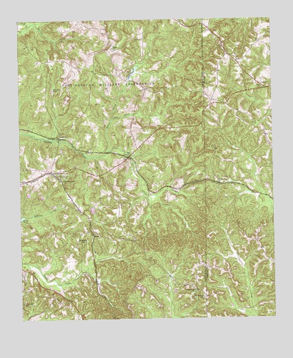
Glen Alta, GA USGS Topographic Map
Click on map above to begin viewing in our Map Viewer.

This topographic map contains these locations and features:
Feature Name Type Latitude Longitude GNIS ID View Map
Anderson LakeReservoirN32.3206°W84.7290°340556View Map
Anderson Lake DamDamN32.3218°W84.7283°340555View Map
Bagley LakeReservoirN32.2959°W84.7141°340554View Map
Bagley Lake DamDamN32.2968°W84.7149°340553View Map
Bush HillSummitN32.3629°W84.7030°312082View Map
Chattahoochee County Volunteer Fire DepartmentBuildingN32.3100°W84.7307°2603655View Map
Chattahoochee Lookout TowerTowerN32.3099°W84.7310°344207View Map
ChristopherPopulated PlaceN32.3271°W84.7305°331399View Map
Christopher ChurchChurchN32.3074°W84.7291°355162View Map
Daniels PondLakeN32.3460°W84.7331°313298View Map
Friendship ChurchChurchN32.2565°W84.7485°314407View Map
Friendship SchoolSchoolN32.2560°W84.7499°314437View Map
Glen AltaPopulated PlaceN32.3068°W84.6513°356033View Map
Gobblers HillPopulated PlaceN32.2818°W84.7191°331830View Map
Gordy PondReservoirN32.2926°W84.7492°314722View Map
Gordy Pond DamDamN32.2918°W84.7499°340639View Map
Hollis BranchStreamN32.3332°W84.7044°315547View Map
Hollis CreekStreamN32.3204°W84.7063°315548View Map
Hollis Mill (historical)LocaleN32.3499°W84.6941°351035View Map
Ida VesperPopulated PlaceN32.3179°W84.6960°332053View Map
Kingsville School (historical)SchoolN32.3624°W84.7441°351041View Map
Liberty Hill ChurchChurchN32.2610°W84.6644°316834View Map
MantaPopulated PlaceN32.2860°W84.7135°332313View Map
Mission Church (historical)ChurchN32.3704°W84.7063°351046View Map
Prosperity Church (historical)ChurchN32.3626°W84.7435°351055View Map
Saint Mathews SchoolSchoolN32.2588°W84.6602°322212View Map
Saint Paul ChurchChurchN32.3082°W84.6444°344118View Map
Schley PondReservoirN32.3522°W84.6939°322627View Map
Shelton Church (historical)ChurchN32.3740°W84.7185°351065View Map
UnionPopulated PlaceN32.3474°W84.6299°333300View Map
Zion Hills ChurchChurchN32.3115°W84.7344°325705View Map

Note: Coordinates in the location and feature list above are referenced to NAD83 datum.


Copyright (C) 2008-2024 Ryan Niemi / Sunset Dynamics ... All Rights Reserved