TopoQuest Logo
Do you find TopoQuest useful?
Help keep TopoQuest running and adding new maps/features by donating!
Bitcoin:  19c7KJd3qBynnjoSw5npx9KScwjBe4ifkT
Litecoin:  LXs6TkuXGGXo1vDsWCkWVdjQX94eUKd6ui
Home View Maps Find Maps Find Places Resources & Links


Cusseta, Georgia Topographic Map

USGS Map Title: Cusseta, GA
USGS Map MRC: 32084C7
DRG (GeoTIFF) Download: o32084c7.tif


Neighboring USGS Topographic Map Quads:


  Columbus, GA  
32084D8
 

  Ochillee, GA  
32084D7
 

  Buena Vista NW, GA  
32084D6
 

  Fort Benning, GA  
32084C8
 

  Cusseta, GA  
32084C7
 

  Glen Alta, GA  
32084C6
 

  Union, GA  
32084B8
 

  Louvale, GA  
32084B7
 

  Brooklyn, GA  
32084B6


Map MRC Location:

N33°
W85°
N33°
W84°
H8 H7 H6 H5 H4 H3 H2 H1
G8 G7 G6 G5 G4 G3 G2 G1
F8 F7 F6 F5 F4 F3 F2 F1
E8 E7 E6 E5 E4 E3 E2 E1
D8 D7 D6 D5 D4 D3 D2 D1
C8 C7 C6 C5 C4 C3 C2 C1
B8 B7 B6 B5 B4 B3 B2 B1
A8 A7 A6 A5 A4 A3 A2 A1
N32°
W85°
N32°
W84°

Cusseta, GA USGS 1:24K Topographic Map Preview:
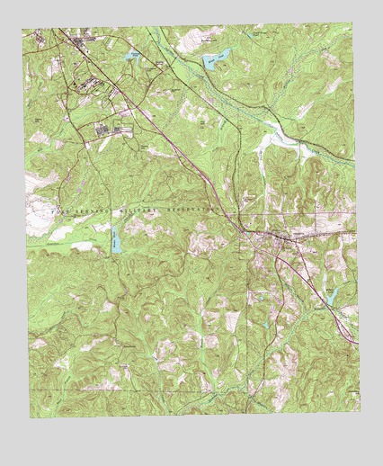
Cusseta, GA USGS Topographic Map
Click on map above to begin viewing in our Map Viewer.

This topographic map contains these locations and features:
Feature Name Type Latitude Longitude GNIS ID View Map
Bagley CreekStreamN32.2829°W84.7624°310713View Map
Bardman HillSummitN32.3540°W84.8194°331089View Map
Central SpringsPopulated PlaceN32.3621°W84.8194°351010View Map
Chattahoochee CountyCivilN32.3470°W84.7870°351012View Map
Chattahoochee County CourthouseBuildingN32.3063°W84.7763°1705267View Map
Chattahoochee County Education CenterSchoolN32.3043°W84.7724°351013View Map
Chattahoochee County JailBuildingN32.3064°W84.7765°2734204View Map
Chattahoochee County Sheriff's OfficeBuildingN32.3065°W84.7766°2733831View Map
Cooks BranchStreamN32.3504°W84.7996°312922View Map
Craston HillSummitN32.3610°W84.8283°331472View Map
CussetaPopulated PlaceN32.3054°W84.7727°355414View Map
Cusseta - Chattahoochee Volunteer Fire DepartmentBuildingN32.3077°W84.7850°2604054View Map
Cusseta DivisionCivilN32.2730°W84.7516°1936208View Map
Cusseta Police DepartmentBuildingN32.3064°W84.7768°2733940View Map
Cusseta Post OfficePost OfficeN32.3051°W84.7777°351018View Map
Fort Benning DivisionCivilN32.3703°W84.7983°1936272View Map
Goodhope CemeteryCemeteryN32.2660°W84.8371°314689View Map
Halloca (historical)Populated PlaceN32.3485°W84.7833°351027View Map
Halloca CreekStreamN32.3457°W84.7891°356144View Map
Harmony Baptist ChurchChurchN32.3076°W84.7838°351029View Map
Harmony CemeteryCemeteryN32.3065°W84.7852°315136View Map
Hewell CreekStreamN32.2560°W84.8049°315352View Map
JamestownPopulated PlaceN32.2724°W84.8391°332089View Map
Kings PondReservoirN32.3641°W84.8022°316458View Map
Kings Pond DamDamN32.3635°W84.8066°338547View Map
Kisseck Pond (historical)ReservoirN32.3576°W84.8583°351042View Map
Little Hichitee CreekStreamN32.2582°W84.7949°317085View Map
McKenna HillSummitN32.3707°W84.8055°317940View Map
Millers LakeReservoirN32.2872°W84.7596°318275View Map
Millers Lake DamDamN32.2879°W84.7591°340551View Map
Mount Olive ChurchChurchN32.3074°W84.7785°318746View Map
Providence School (historical)SchoolN32.2543°W84.7971°351056View Map
Ray HillSummitN32.3432°W84.8085°321333View Map
Reeve HillSummitN32.3454°W84.8708°332823View Map
Ryans HillSummitN32.3365°W84.8313°332947View Map
Saint Pauls ChurchChurchN32.3035°W84.7774°322260View Map
Schley Pond (historical)ReservoirN32.3454°W84.8571°351062View Map
Spring BranchStreamN32.3396°W84.7799°323360View Map
Stevens BranchStreamN32.2804°W84.7710°323589View Map
Sulphur SpringSpringN32.3629°W84.8249°323731View Map
Sweet Home Church (historical)ChurchN32.3499°W84.8335°351066View Map
Unified Government of Cusseta-Chattahoochee CountyCivilN32.3470°W84.7870°2405079View Map
Upper Kings PondReservoirN32.3715°W84.7887°324623View Map
Victoria PondReservoirN32.3658°W84.8330°324697View Map
Victory LodgeBuildingN32.3640°W84.8335°324703View Map
Victory PondReservoirN32.3718°W84.8299°338550View Map
Victory Pond DamDamN32.3626°W84.8066°338549View Map
Weems PondReservoirN32.3063°W84.8409°324967View Map
Weems Pond DamDamN32.3071°W84.8410°338553View Map
Wilkinson CemeteryCemeteryN32.3185°W84.7924°325309View Map
WRBL-TV (Columbus)TowerN32.3238°W84.7794°352852View Map
WTVM-TV (Columbus)TowerN32.3238°W84.7794°352851View Map
WVRK-FM (Columbus)TowerN32.3238°W84.7794°352666View Map

Note: Coordinates in the location and feature list above are referenced to NAD83 datum.


Copyright (C) 2008-2024 Ryan Niemi / Sunset Dynamics ... All Rights Reserved