TopoQuest Logo
Do you find TopoQuest useful?
Help keep TopoQuest running and adding new maps/features by donating!
Bitcoin:  19c7KJd3qBynnjoSw5npx9KScwjBe4ifkT
Litecoin:  LXs6TkuXGGXo1vDsWCkWVdjQX94eUKd6ui
Home View Maps Find Maps Find Places Resources & Links


Chittenden, Vermont Topographic Map

USGS Map Title: Chittenden, VT
USGS Map MRC: 43072F8
DRG (GeoTIFF) Download: o43072f8.tif


Neighboring USGS Topographic Map Quads:


  Brandon, VT  
43073G1
 

  Mount Carmel, VT  
43072G8
 

  Rochester, VT  
43072G7
 

  Proctor, VT  
43073F1
 

  Chittenden, VT  
43072F8
 

  Pico Peak, VT  
43072F7
 

  West Rutland, VT  
43073E1
 

  Rutland, VT  
43072E8
 

  Killington Peak, VT  
43072E7


Map MRC Location:

N44°
W73°
N44°
W72°
H8 H7 H6 H5 H4 H3 H2 H1
G8 G7 G6 G5 G4 G3 G2 G1
F8 F7 F6 F5 F4 F3 F2 F1
E8 E7 E6 E5 E4 E3 E2 E1
D8 D7 D6 D5 D4 D3 D2 D1
C8 C7 C6 C5 C4 C3 C2 C1
B8 B7 B6 B5 B4 B3 B2 B1
A8 A7 A6 A5 A4 A3 A2 A1
N43°
W73°
N43°
W72°

Chittenden, VT USGS 1:24K Topographic Map Preview:
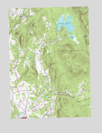
Chittenden, VT USGS Topographic Map
Click on map above to begin viewing in our Map Viewer.

This topographic map contains these locations and features:
Feature Name Type Latitude Longitude GNIS ID View Map
Baird CemeteryCemeteryN43.6906°W72.9541°1460539View Map
Bald PeakSummitN43.7173°W72.9787°1460549View Map
Barstow Memorial SchoolSchoolN43.7010°W72.9523°1460562View Map
Billings BrookStreamN43.7401°W72.9179°1460610View Map
Blue Ridge AcresPopulated PlaceN43.6340°W72.9621°1921752View Map
Blue Ridge MountainSummitN43.6781°W72.9021°1460627View Map
Blueberry HillSummitN43.6773°W72.9632°1460628View Map
Brewers BrookStreamN43.6426°W72.8918°1460658View Map
Burr PondLakeN43.6932°W72.9658°1460685View Map
Camp SangamonLocaleN43.6948°W72.9554°1921782View Map
Canty TrailTrailN43.6781°W72.8920°1460699View Map
Center of Rutland Fire Department - McKinley StationBuildingN43.6354°W72.9804°2121260View Map
Chasanna AcresPopulated PlaceN43.6431°W72.9598°1921803View Map
Cheney Hill CemeteryCemeteryN43.6617°W72.9941°1921804View Map
ChittendenPopulated PlaceN43.7078°W72.9482°1460723View Map
Chittenden DamDamN43.7231°W72.9234°1460727View Map
Chittenden Post OfficePost OfficeN43.6974°W72.9522°1921806View Map
Chittenden ReservoirReservoirN43.7309°W72.9109°1460728View Map
Chittenden Town HallBuildingN43.7076°W72.9551°1921807View Map
Chittenden Volunteer Fire DepartmentBuildingN43.7064°W72.9491°2121282View Map
Colonial EstatesPopulated PlaceN43.6545°W72.9671°1921823View Map
Countryside EstatesPopulated PlaceN43.6428°W72.9721°1921830View Map
District School Number 15SchoolN43.6292°W72.9454°1460792View Map
Dwight D Eisenhower National Fish HatcheryParkN43.7406°W72.9777°2765277View Map
East PittsfordPopulated PlaceN43.6712°W72.9429°1460835View Map
East Pittsford CemeteryCemeteryN43.6743°W72.9436°1921854View Map
Eggelston CemeteryCemeteryN43.6602°W72.8908°1921864View Map
Frederic D Barstow Memorial LibraryBuildingN43.7073°W72.9551°1921893View Map
Glen DamDamN43.6501°W72.9529°1766704View Map
Green BrookStreamN43.7392°W72.9090°1460930View Map
Hewitt BrookStreamN43.7292°W72.9246°1460986View Map
Horton CemeteryCemeteryN43.7101°W72.9484°1461005View Map
Killington GatewayLocaleN43.6542°W72.8870°1921952View Map
Lefferts DamDamN43.7156°W72.9018°1766633View Map
Lefferts PondLakeN43.7159°W72.9014°1461062View Map
Long HillSummitN43.7173°W72.9787°1461094View Map
MendonPopulated PlaceN43.6515°W72.9271°1461139View Map
Mendon BrookStreamN43.6523°W72.9501°1461140View Map
Mendon Fish and Game ClubLocaleN43.6742°W72.9426°1921973View Map
Mendon Town HallBuildingN43.6456°W72.9293°1921975View Map
Mill Village ChapelChurchN43.6384°W72.9759°1461161View Map
Mountain CemeteryCemeteryN43.6470°W72.9004°1921982View Map
Mountain Top ClubLocaleN43.7303°W72.9384°1461187View Map
Mountain View Community SchoolSchoolN43.6295°W72.9816°2427575View Map
Mountain View EstatesPopulated PlaceN43.6637°W72.9940°1921985View Map
Norman Rockwell MuseumBuildingN43.6276°W72.9465°1921999View Map
North ChittendenPopulated PlaceN43.7403°W72.9759°1461223View Map
North PondLakeN43.7489°W72.8857°1461231View Map
Northwood ParkParkN43.6465°W72.9479°1922006View Map
Patch DamDamN43.6309°W72.9823°1766646View Map
Patch PondLakeN43.6303°W72.9830°1461258View Map
Pinecrest AcresPopulated PlaceN43.6537°W72.9559°1922034View Map
Pinnacle RidgePopulated PlaceN43.6601°W72.9984°1922035View Map
Prospect HillPopulated PlaceN43.6570°W72.9737°1461298View Map
Rutland City ForestForestN43.6390°W72.8970°1461362View Map
Rutland City ReservoirReservoirN43.6489°W72.9430°1461363View Map
Rutland City Reservoir DamDamN43.6484°W72.9451°1766702View Map
Rutland Golf CourseLocaleN43.6270°W72.9884°1922078View Map
Rutland Municipal ForestForestN43.6465°W72.9612°1922087View Map
Rutland Regional Chamber of CommerceBuildingN43.6265°W72.9754°1922090View Map
Rutland Town Elementary SchoolSchoolN43.6387°W72.9636°2427558View Map
South Pond TrailTrailN43.7153°W72.8862°1461444View Map
Sugarwood HillPopulated PlaceN43.6653°W72.9857°1922146View Map
Tenney CemeteryCemeteryN43.6554°W72.9339°1922152View Map
Town of MendonCivilN43.6262°W72.8787°1462145View Map
Twin Bridge (historical)BridgeN43.6520°W72.9732°1922166View Map
Velco HeliportAirportN43.6598°W72.9923°1461952View Map
Vermont State Police Troop B Rutland BarracksBuildingN43.6357°W72.9773°2752797View Map

Note: Coordinates in the location and feature list above are referenced to NAD83 datum.


Copyright (C) 2008-2024 Ryan Niemi / Sunset Dynamics ... All Rights Reserved