TopoQuest Logo
Do you find TopoQuest useful?
Help keep TopoQuest running and adding new maps/features by donating!
Bitcoin:  19c7KJd3qBynnjoSw5npx9KScwjBe4ifkT
Litecoin:  LXs6TkuXGGXo1vDsWCkWVdjQX94eUKd6ui
Home View Maps Find Maps Find Places Resources & Links


West Rutland, Vermont Topographic Map

USGS Map Title: West Rutland, VT
USGS Map MRC: 43073E1
DRG (GeoTIFF) Download: o43073e1.tif


Neighboring USGS Topographic Map Quads:


  Bomoseen, VT  
43073F2
 

  Proctor, VT  
43073F1
 

  Chittenden, VT  
43072F8
 

  Poultney, VT  
43073E2
 

  West Rutland, VT  
43073E1
 

  Rutland, VT  
43072E8
 

  Wells, VT  
43073D2
 

  Middletown Springs, VT  
43073D1
 

  Wallingford, VT  
43072D8


Map MRC Location:

N44°
W74°
N44°
W73°
H8 H7 H6 H5 H4 H3 H2 H1
G8 G7 G6 G5 G4 G3 G2 G1
F8 F7 F6 F5 F4 F3 F2 F1
E8 E7 E6 E5 E4 E3 E2 E1
D8 D7 D6 D5 D4 D3 D2 D1
C8 C7 C6 C5 C4 C3 C2 C1
B8 B7 B6 B5 B4 B3 B2 B1
A8 A7 A6 A5 A4 A3 A2 A1
N43°
W74°
N43°
W73°

West Rutland, VT USGS 1:24K Topographic Map Preview:
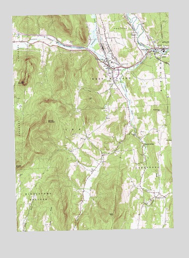
West Rutland, VT USGS Topographic Map
Click on map above to begin viewing in our Map Viewer.

This topographic map contains these locations and features:
Feature Name Type Latitude Longitude GNIS ID View Map
Bird MountainSummitN43.5862°W73.1157°1456430View Map
Bird Mountain Wildlife Management AreaParkN43.5781°W73.1221°1921748View Map
Boardman HillSummitN43.5684°W73.0084°1456502View Map
Center RutlandPopulated PlaceN43.6045°W73.0115°1456822View Map
Center Rutland CemeteryCemeteryN43.6041°W73.0084°1921797View Map
Center Rutland DamDamN43.6034°W73.0129°1766654View Map
Center Rutland FallsFallsN43.6037°W73.0140°1921798View Map
Center Rutland Fire DepartmentBuildingN43.6031°W73.0158°2121258View Map
ChippenhookPopulated PlaceN43.5184°W73.0140°1456884View Map
Clarendon RiverStreamN43.6051°W73.0176°1456896View Map
Clarendon SpringsPopulated PlaceN43.5478°W73.0223°1456897View Map
Clarendon Volunteer Fire Association Station 2BuildingN43.5211°W73.0140°2121271View Map
Clark HillSummitN43.5762°W73.0662°1456902View Map
College of Saint JosephSchoolN43.6005°W73.0009°1921821View Map
Durgy Hill HeightsPopulated PlaceN43.6109°W73.0479°1921849View Map
Edmunds CemeteryCemeteryN43.5150°W73.0214°1457344View Map
Edmunds PeakSummitN43.5087°W73.0473°1457345View Map
Evergreen CemeteryCemeteryN43.6067°W73.0073°1457383View Map
Flat RockSummitN43.5509°W73.0046°1457452View Map
Herrick MountainSummitN43.5626°W73.0987°1457803View Map
IraPopulated PlaceN43.5345°W73.0621°1457969View Map
Ira Baptist ChurchChurchN43.5328°W73.0632°1921942View Map
Ira BrookStreamN43.5576°W73.0284°1457970View Map
Ira Town HallBuildingN43.5348°W73.0626°1921944View Map
Ira Volunteer Fire DepartmentBuildingN43.5242°W73.0705°2121259View Map
Marble Street Historic DistrictParkN43.5987°W73.0496°1921967View Map
Old Center Rutland School (historical)SchoolN43.6042°W73.0082°1922013View Map
Pleasant Street CemeteryCemeteryN43.5950°W73.0390°1458999View Map
Riverside CemeteryCemeteryN43.5394°W73.0565°1459200View Map
Rutland CountyCivilN43.5801°W73.0366°1461767View Map
Sacred Heart CemeteryCemeteryN43.5962°W73.0534°1922094View Map
Saint Bridgets CemeteryCemeteryN43.5965°W73.0551°1922099View Map
Saint Joseph College LibraryBuildingN43.6001°W73.0068°1922105View Map
Saint Joseph NovitiateChurchN43.5992°W73.0023°1459331View Map
Saint Stanislaus Kostka Catholic ChurchChurchN43.5970°W73.0532°1922111View Map
Saint Stanislaus Kostka CemeteryCemeteryN43.5967°W73.0543°1922112View Map
Saint Stanislaus Kostka SchoolSchoolN43.5981°W73.0512°1459348View Map
Spruce KnobSummitN43.5381°W73.1246°1459651View Map
Town of IraCivilN43.5530°W73.0819°1462123View Map
Town of West RutlandCivilN43.6138°W73.0617°1462256View Map
United Church of West RutlandChurchN43.5937°W73.0487°1922169View Map
West Clarendon CemeteryCemeteryN43.5213°W73.0176°1460127View Map
West RutlandPopulated PlaceN43.5931°W73.0451°1460169View Map
West Rutland Census Designated PlaceCensusN43.5972°W73.0451°2378138View Map
West Rutland Fire DepartmentBuildingN43.5973°W73.0495°2121285View Map
West Rutland Municipal ForestForestN43.5698°W73.0773°1922198View Map
West Rutland Post OfficePost OfficeN43.5925°W73.0438°1922199View Map
West Rutland SchoolSchoolN43.5957°W73.0514°1922200View Map
West Rutland Town HallBuildingN43.5937°W73.0473°1922202View Map
Whipple HollowValleyN43.6056°W73.0582°1460209View Map
WHWB-AM (Rutland)TowerN43.6120°W73.0265°1461882View Map
WHWB-FM (Rutland)TowerN43.6137°W73.0254°1461901View Map
WRUT-FM (West Rutland)TowerN43.5678°W73.0079°1461909View Map
Youngs Brook DamDamN43.5717°W73.0512°1766585View Map
Youngs Brook ReservoirReservoirN43.5716°W73.0522°1766586View Map

Note: Coordinates in the location and feature list above are referenced to NAD83 datum.


Copyright (C) 2008-2024 Ryan Niemi / Sunset Dynamics ... All Rights Reserved