TopoQuest Logo
Do you find TopoQuest useful?
Help keep TopoQuest running and adding new maps/features by donating!
Bitcoin:  19c7KJd3qBynnjoSw5npx9KScwjBe4ifkT
Litecoin:  LXs6TkuXGGXo1vDsWCkWVdjQX94eUKd6ui
Home View Maps Find Maps Find Places Resources & Links


Alvin, South Carolina Topographic Map

USGS Map Title: Alvin, SC
USGS Map MRC: 33079C7
DRG (GeoTIFF) Download: o33079c7.tif


Neighboring USGS Topographic Map Quads:


  Saint Stephen, SC  
33079D8
 

  Blakely, SC  
33079D7
 

  Trio, SC  
33079D6
 

  Bonneau, SC  
33079C8
 

  Alvin, SC  
33079C7
 

  Jamestown, SC  
33079C6
 

  Cordesville, SC  
33079B8
 

  Bethera, SC  
33079B7
 

  Shulerville, SC  
33079B6


Map MRC Location:

N34°
W80°
N34°
W79°
H8 H7 H6 H5 H4 H3 H2 H1
G8 G7 G6 G5 G4 G3 G2 G1
F8 F7 F6 F5 F4 F3 F2 F1
E8 E7 E6 E5 E4 E3 E2 E1
D8 D7 D6 D5 D4 D3 D2 D1
C8 C7 C6 C5 C4 C3 C2 C1
B8 B7 B6 B5 B4 B3 B2 B1
A8 A7 A6 A5 A4 A3 A2 A1
N33°
W80°
N33°
W79°

Alvin, SC USGS 1:24K Topographic Map Preview:
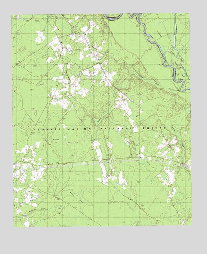
Alvin, SC USGS Topographic Map
Click on map above to begin viewing in our Map Viewer.

This topographic map contains these locations and features:
Feature Name Type Latitude Longitude GNIS ID View Map
AlvinPopulated PlaceN33.3491°W79.8162°1231003View Map
Alvin Fire DepartmentBuildingN33.3466°W79.8150°2368267View Map
Beauford BranchStreamN33.3407°W79.7895°1245001View Map
Beaver Dam SwampSwampN33.2985°W79.7851°1220428View Map
Bethlehem ChurchChurchN33.3627°W79.8273°1246821View Map
Bullhead BayBasinN33.3091°W79.8440°1247061View Map
CalestownPopulated PlaceN33.2904°W79.7867°1235260View Map
Calestown ChurchChurchN33.2610°W79.7626°1247087View Map
Edens CemeteryCemeteryN33.3527°W79.8192°1235262View Map
Emmanuel ChurchChurchN33.3238°W79.7901°1247669View Map
Gravel Hill Lookout TowerTowerN33.3457°W79.8715°1252180View Map
Hickory Grove (historical)Populated PlaceN33.2516°W79.8623°1235264View Map
Holly Hill ChurchChurchN33.3274°W79.7956°1246020View Map
Hoods Chapel CemeteryCemeteryN33.2777°W79.8579°1235266View Map
Hoods Chapel Methodist ChurchChurchN33.2779°W79.8579°1235267View Map
Hopes ChapelChurchN33.2843°W79.8681°1235268View Map
Johnson CemeteryCemeteryN33.2815°W79.8065°1235269View Map
Johnson ChurchChurchN33.2807°W79.8067°1246182View Map
Laurel Hill SchoolSchoolN33.3474°W79.8142°1223833View Map
Macedonia CemeteryCemeteryN33.2846°W79.8704°1235270View Map
Macedonia ChurchChurchN33.2846°W79.8709°1246499View Map
Meeting House BranchStreamN33.3110°W79.8165°1246617View Map
Mount Calvary CemeteryCemeteryN33.2910°W79.7873°1235271View Map
Mount Calvary Holiness ChurchChurchN33.2904°W79.7876°1235272View Map
New Emanuel School (historical)SchoolN33.2871°W79.7570°1706236View Map
New Emmanuel ChurchChurchN33.2871°W79.7576°1224966View Map
Rogers BridgeBridgeN33.2971°W79.7651°1235273View Map
Santee ChurchChurchN33.3343°W79.8312°1226395View Map
Savanna CreekPopulated PlaceN33.2868°W79.7573°1235275View Map
Sugar Loaf Plantation (historical)LocaleN33.3179°W79.8206°1235276View Map
Taylor CemeteryCemeteryN33.2688°W79.8554°1235277View Map
Von Hollen CemeteryCemeteryN33.2990°W79.7901°1235278View Map
Wallace SwampSwampN33.2671°W79.8306°1235279View Map
Wedboo BayBasinN33.3002°W79.7998°1235280View Map
Wedboo BridgeBridgeN33.3316°W79.8023°1235281View Map
Wedboo CreekStreamN33.3293°W79.7570°1227456View Map

Note: Coordinates in the location and feature list above are referenced to NAD83 datum.


Copyright (C) 2008-2024 Ryan Niemi / Sunset Dynamics ... All Rights Reserved