TopoQuest Logo
Do you find TopoQuest useful?
Help keep TopoQuest running and adding new maps/features by donating!
Bitcoin:  19c7KJd3qBynnjoSw5npx9KScwjBe4ifkT
Litecoin:  LXs6TkuXGGXo1vDsWCkWVdjQX94eUKd6ui
Home View Maps Find Maps Find Places Resources & Links


Saint Stephen, South Carolina Topographic Map

USGS Map Title: Saint Stephen, SC
USGS Map MRC: 33079D8
DRG (GeoTIFF) Download: o33079d8.tif


Neighboring USGS Topographic Map Quads:


  Butlers Bay, SC  
33080E1
 

  Greeleyville, SC  
33079E8
 

  Salters, SC  
33079E7
 

  Pineville, SC  
33080D1
 

  Saint Stephen, SC  
33079D8
 

  Blakely, SC  
33079D7
 

  Chicora, SC  
33080C1
 

  Bonneau, SC  
33079C8
 

  Alvin, SC  
33079C7


Map MRC Location:

N34°
W80°
N34°
W79°
H8 H7 H6 H5 H4 H3 H2 H1
G8 G7 G6 G5 G4 G3 G2 G1
F8 F7 F6 F5 F4 F3 F2 F1
E8 E7 E6 E5 E4 E3 E2 E1
D8 D7 D6 D5 D4 D3 D2 D1
C8 C7 C6 C5 C4 C3 C2 C1
B8 B7 B6 B5 B4 B3 B2 B1
A8 A7 A6 A5 A4 A3 A2 A1
N33°
W80°
N33°
W79°

Saint Stephen, SC USGS 1:24K Topographic Map Preview:
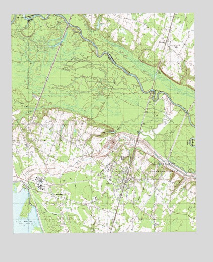
Saint Stephen, SC USGS Topographic Map
Click on map above to begin viewing in our Map Viewer.

This topographic map contains these locations and features:
Feature Name Type Latitude Longitude GNIS ID View Map
Berkeley County Library Saint Stephen BranchBuildingN33.4004°W79.9239°2490357View Map
Bible Way Church (historical)ChurchN33.3779°W79.9181°1706233View Map
Big BayBasinN33.4038°W79.9540°1229408View Map
Big Bay BranchStreamN33.4310°W79.9020°1229409View Map
Bryant ChapelChurchN33.3952°W79.9170°1229471View Map
Calvary ChurchChurchN33.4352°W79.9729°1234284View Map
Doctor PondSwampN33.3876°W79.8773°1229640View Map
GourdinPopulated PlaceN33.4835°W79.8959°1245794View Map
Halfway SwampStreamN33.3782°W79.9454°1229766View Map
Harris TownPopulated PlaceN33.3796°W79.9031°1234314View Map
I K Gourdin SchoolSchoolN33.4260°W79.9895°1229836View Map
J K Gourdin Elementary SchoolSchoolN33.4253°W79.9907°1234323View Map
J P Gamble PondReservoirN33.4752°W79.9398°1239707View Map
J P Gamble Pond DamDamN33.4752°W79.9398°1239706View Map
Keller CemeteryCemeteryN33.3996°W79.8823°1234327View Map
Kelley BranchStreamN33.4057°W79.8779°1234328View Map
Lane Airport (historical)AirportN33.4818°W79.8873°1241451View Map
Lifeland BranchStreamN33.4452°W79.9898°1229906View Map
Macedonia ChurchChurchN33.4921°W79.9067°1241457View Map
Macedonia SchoolSchoolN33.4927°W79.9067°1229966View Map
Milton ChapelChurchN33.4252°W79.9895°1230023View Map
Mount Pismal ChurchChurchN33.4127°W79.9487°1249650View Map
Murrays Ferry (historical)CrossingN33.4946°W79.9609°1241474View Map
Murrays Ferry BridgeBridgeN33.4946°W79.9609°1241475View Map
North End (historical)Populated PlaceN33.4293°W79.9151°1234353View Map
Old PeruPopulated PlaceN33.4204°W79.9867°1234356View Map
Oldfield PlantationLocaleN33.4399°W79.9734°1234357View Map
Oldfield Plantation CemeteryCemeteryN33.4393°W79.9734°1234358View Map
Penn BranchStreamN33.4896°W79.9409°1250060View Map
Pineville Fire DepartmentBuildingN33.4243°W79.9915°2368268View Map
Ponteaux BranchStreamN33.4082°W79.8773°1230190View Map
RussellvillePopulated PlaceN33.3971°W79.9717°1230264View Map
Russellville CemeteryCemeteryN33.3929°W79.9704°1234374View Map
Russellville Census Designated PlaceCensusN33.3970°W79.9637°2629836View Map
Russellville Christian ChurchChurchN33.3935°W79.9706°1234375View Map
Russellville Post OfficePost OfficeN33.4091°W79.9862°1251830View Map
Russellville School (historical)SchoolN33.4077°W79.9792°1234376View Map
Saint James ChurchChurchN33.4749°W79.8834°1241497View Map
Saint James SchoolSchoolN33.4752°W79.8842°1230268View Map
Saint Marys Holiness ChurchChurchN33.4077°W79.9829°1234379View Map
Saint Matthews ChurchChurchN33.4260°W79.9506°1230277View Map
Saint Michaels ChurchChurchN33.4143°W79.9290°1706241View Map
Saint Peters ChurchChurchN33.4071°W79.9781°1234381View Map
Saint StephenPopulated PlaceN33.4043°W79.9217°1250704View Map
Saint Stephen Baptist ChurchChurchN33.3935°W79.9198°1234382View Map
Saint Stephen CemeteryCemeteryN33.3927°W79.9184°1234383View Map
Saint Stephen Elementary SchoolSchoolN33.3987°W79.9288°1234384View Map
Saint Stephen Fire DepartmentBuildingN33.4037°W79.9211°2368201View Map
Saint Stephen Golf CourseLocaleN33.4053°W79.9258°2490055View Map
Saint Stephen High SchoolSchoolN33.3946°W79.9431°1234385View Map
Saint Stephen Middle SchoolSchoolN33.4053°W79.9338°1234386View Map
Saint Stephen Police DepartmentBuildingN33.4028°W79.9213°2334980View Map
Saint Stephen Post OfficePost OfficeN33.4088°W79.9284°1252152View Map
Saint Stephens CemeteryCemeteryN33.4052°W79.9167°1234387View Map
Saint Stephens Episcopal ChurchChurchN33.4054°W79.9167°1234388View Map
Santee (historical)Populated PlaceN33.4549°W79.9045°1251767View Map
Sunset Memorial CemeteryCemeteryN33.4060°W79.9109°1234399View Map
Swamp FoxPopulated PlaceN33.4404°W79.9859°1234400View Map
Town of Saint StephenCivilN33.4046°W79.9263°2407274View Map
WTUA-FM (Saint Stephen)TowerN33.4935°W79.8890°1252548View Map

Note: Coordinates in the location and feature list above are referenced to NAD83 datum.


Copyright (C) 2008-2024 Ryan Niemi / Sunset Dynamics ... All Rights Reserved