TopoQuest Logo
Do you find TopoQuest useful?
Help keep TopoQuest running and adding new maps/features by donating!
Bitcoin:  19c7KJd3qBynnjoSw5npx9KScwjBe4ifkT
Litecoin:  LXs6TkuXGGXo1vDsWCkWVdjQX94eUKd6ui
Home View Maps Find Maps Find Places Resources & Links


Bonneau, South Carolina Topographic Map

USGS Map Title: Bonneau, SC
USGS Map MRC: 33079C8
DRG (GeoTIFF) Download: o33079c8.tif


Neighboring USGS Topographic Map Quads:


  Pineville, SC  
33080D1
 

  Saint Stephen, SC  
33079D8
 

  Blakely, SC  
33079D7
 

  Chicora, SC  
33080C1
 

  Bonneau, SC  
33079C8
 

  Alvin, SC  
33079C7
 

  Moncks Corner, SC  
33080B1
 

  Cordesville, SC  
33079B8
 

  Bethera, SC  
33079B7


Map MRC Location:

N34°
W80°
N34°
W79°
H8 H7 H6 H5 H4 H3 H2 H1
G8 G7 G6 G5 G4 G3 G2 G1
F8 F7 F6 F5 F4 F3 F2 F1
E8 E7 E6 E5 E4 E3 E2 E1
D8 D7 D6 D5 D4 D3 D2 D1
C8 C7 C6 C5 C4 C3 C2 C1
B8 B7 B6 B5 B4 B3 B2 B1
A8 A7 A6 A5 A4 A3 A2 A1
N33°
W80°
N33°
W79°

Bonneau, SC USGS 1:24K Topographic Map Preview:
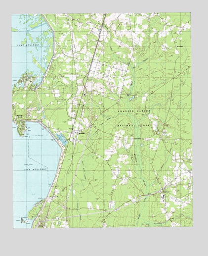
Bonneau, SC USGS Topographic Map
Click on map above to begin viewing in our Map Viewer.

This topographic map contains these locations and features:
Feature Name Type Latitude Longitude GNIS ID View Map
Bethel ChurchChurchN33.3418°W79.9226°1229403View Map
Black Oak CemeteryCemeteryN33.3135°W79.9954°1234278View Map
BonneauPopulated PlaceN33.3054°W79.9579°1246941View Map
Bonneau Beach Census Designated PlaceCensusN33.3229°W79.9900°2584530View Map
Bonneau CemeteryCemeteryN33.2899°W79.9590°1234279View Map
Bonneau DivisionCivilN33.2943°W79.8984°1938207View Map
Bonneau Fire DepartmentBuildingN33.3039°W79.9527°2368403View Map
Bonneau Fire TowerTowerN33.3177°W79.9512°1242361View Map
Bonneau Police DepartmentBuildingN33.3037°W79.9527°2334978View Map
Bonneau Post OfficePost OfficeN33.3073°W79.9543°2489775View Map
Bonneau Vocational CenterSchoolN33.3277°W79.9492°1234280View Map
Browns BranchStreamN33.3121°W79.9126°1252148View Map
Camp MoultrieLocaleN33.2602°W79.9865°1234285View Map
Canal Picnic AreaLocaleN33.2727°W79.9640°1230589View Map
Cane Pond BranchStreamN33.2527°W79.9051°1229519View Map
Church of GodChurchN33.2760°W79.8773°1234289View Map
Dingle Temple ChurchChurchN33.3657°W79.9376°1234295View Map
Forty One Rural Fire DepartmentBuildingN33.3433°W79.9269°2368107View Map
Fox SwampStreamN33.3232°W79.9198°1244073View Map
Full Gospel Mission CemeteryCemeteryN33.3041°W79.9315°1234306View Map
Full Gospel Mission ChurchChurchN33.3041°W79.9312°1234307View Map
Good Shepherd ChurchChurchN33.3391°W79.9481°1229739View Map
Gravel Hill (historical)Populated PlaceN33.3260°W79.9062°1234310View Map
Gravel Hill CemeteryCemeteryN33.3257°W79.9146°1229745View Map
Gravel Hill LakeReservoirN33.3254°W79.9162°1230590View Map
Gravel Hill SwampStreamN33.3160°W79.9167°1229746View Map
HarristownPopulated PlaceN33.3563°W79.8859°1231366View Map
Henry E Bonner Elementary SchoolSchoolN33.2654°W79.8956°2486450View Map
Hickory Grove Pentecostal Holiness ChurchChurchN33.2893°W79.8801°1234315View Map
Holy Rock ChurchChurchN33.3096°W79.9445°1229810View Map
Island BranchStreamN33.2693°W79.9062°1252181View Map
Jefferies DamDamN33.2785°W79.9781°1238853View Map
Jehovah ChurchChurchN33.3488°W79.9556°1229847View Map
Jervy Chapel SchoolSchoolN33.3682°W79.9092°1229856View Map
Lake Moultrie Fire DepartmentBuildingN33.3306°W79.9906°2368390View Map
Lake Moultrie Fire DepartmentBuildingN33.3134°W79.9964°2368214View Map
MacbethPopulated PlaceN33.2677°W79.9748°1229963View Map
Macedonia Fire Department Station 1BuildingN33.2735°W79.8949°2368117View Map
Macedonia Middle SchoolSchoolN33.2684°W79.8968°1234335View Map
Macedonia SchoolSchoolN33.2682°W79.8954°1246511View Map
Mudlake CemeteryCemeteryN33.3379°W79.9651°1234347View Map
Oak Grove CemeteryCemeteryN33.3052°W79.8979°1234354View Map
Oak Grove ChurchChurchN33.2838°W79.8767°1249907View Map
ProvidencePopulated PlaceN33.2704°W79.8987°1244074View Map
Providence Baptist ChurchChurchN33.2707°W79.8981°1250260View Map
Providence CemeteryCemeteryN33.2704°W79.8970°1234367View Map
Rehobeth CemeteryCemeteryN33.2629°W79.9651°1234370View Map
Rehoboth ChurchChurchN33.2632°W79.9651°1250337View Map
Richardson LandingPopulated PlaceN33.3085°W79.9765°1231724View Map
Saint John ChurchChurchN33.2518°W79.9634°1230270View Map
Saint Mark ChurchChurchN33.3143°W79.9954°1250585View Map
Saint Paul ChurchChurchN33.3646°W79.9165°1250643View Map
Saint Peter ChurchChurchN33.3307°W79.9226°1250682View Map
Santee Circle Fire Department Station 2BuildingN33.2642°W79.9784°2368467View Map
South Carolina Law Enforcement DivisionBuildingN33.3063°W79.9665°2334982View Map
Spring Grove PlantationLocaleN33.3004°W79.9054°1234392View Map
Spring Grove SwampSwampN33.2854°W79.9423°1230356View Map
Stewart CreekStreamN33.2729°W79.9070°1230366View Map
Sumter ChapelChurchN33.3549°W79.9579°1230386View Map
Sumter School (historical)SchoolN33.3549°W79.9576°1234398View Map
Swamp Fox Ranger StationBuildingN33.2507°W79.9626°1244075View Map
Swamp Fox Ranger StationLocaleN33.2535°W79.9623°1230388View Map
Timberland High SchoolSchoolN33.3367°W79.8905°2486425View Map
Town of BonneauCivilN33.3081°W79.9573°2405302View Map
Walker SwampStreamN33.3427°W79.9148°1230453View Map
Whiskinboo CreekStreamN33.2529°W79.9131°1251406View Map
WilderPopulated PlaceN33.3471°W79.9431°1230591View Map
Wilder (historical)Populated PlaceN33.3474°W79.9437°1234410View Map

Note: Coordinates in the location and feature list above are referenced to NAD83 datum.


Copyright (C) 2008-2024 Ryan Niemi / Sunset Dynamics ... All Rights Reserved