TopoQuest Logo
Do you find TopoQuest useful?
Help keep TopoQuest running and adding new maps/features by donating!
Bitcoin:  19c7KJd3qBynnjoSw5npx9KScwjBe4ifkT
Litecoin:  LXs6TkuXGGXo1vDsWCkWVdjQX94eUKd6ui
Home View Maps Find Maps Find Places Resources & Links


Cementon, New York Topographic Map

USGS Map Title: Cementon, NY
USGS Map MRC: 42073B8
DRG (GeoTIFF) Download: o42073b8.tif


Neighboring USGS Topographic Map Quads:


  Freehold, NY  
42074C1
 

  Leeds, NY  
42073C8
 

  Hudson North, NY  
42073C7
 

  Kaaterskill Clove, NY  
42074B1
 

  Cementon, NY  
42073B8
 

  Hudson South, NY  
42073B7
 

  Woodstock, NY  
42074A1
 

  Saugerties, NY  
42073A8
 

  Clermont, NY  
42073A7


Map MRC Location:

N43°
W74°
N43°
W73°
H8 H7 H6 H5 H4 H3 H2 H1
G8 G7 G6 G5 G4 G3 G2 G1
F8 F7 F6 F5 F4 F3 F2 F1
E8 E7 E6 E5 E4 E3 E2 E1
D8 D7 D6 D5 D4 D3 D2 D1
C8 C7 C6 C5 C4 C3 C2 C1
B8 B7 B6 B5 B4 B3 B2 B1
A8 A7 A6 A5 A4 A3 A2 A1
N42°
W74°
N42°
W73°

Cementon, NY USGS 1:24K Topographic Map Preview:
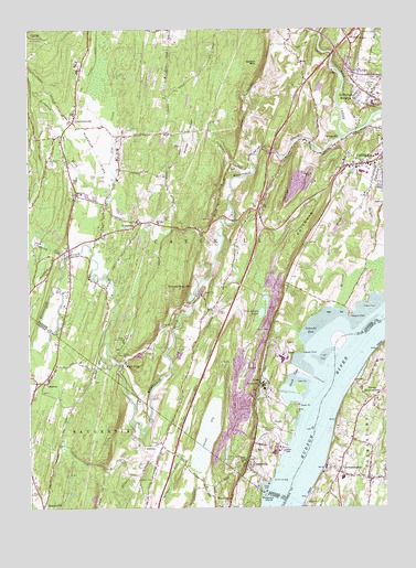
Cementon, NY USGS Topographic Map
Click on map above to begin viewing in our Map Viewer.

This topographic map contains these locations and features:
Feature Name Type Latitude Longitude GNIS ID View Map
AlsenPopulated PlaceN42.1581°W73.9193°972164View Map
Alsen Limestone QuarryMineN42.1742°W73.9167°2633291View Map
AsburyPopulated PlaceN42.1412°W73.9579°972179View Map
Austin GlenValleyN42.2385°W73.8905°974177View Map
Beaver KillStreamN42.1445°W73.9599°969860View Map
Bethel RidgeRidgeN42.2223°W73.9435°943794View Map
Bethel School (historical)SchoolN42.2231°W73.9442°2492975View Map
Bush IslandIslandN42.1686°W73.8917°2704659View Map
Camp On-Ti-OraLocaleN42.1690°W73.9662°945637View Map
Camp Rip Van WinkleLocaleN42.1640°W73.9668°945647View Map
Catskill Toll PlazaLocaleN42.2474°W73.8836°2615056View Map
Catskill Village Fire DepartmentBuildingN42.2132°W73.8802°2718334View Map
Catskill Wesleyan ChurchChurchN42.2094°W73.8763°2615692View Map
CauterskillPopulated PlaceN42.2201°W73.8912°946076View Map
CementonPopulated PlaceN42.1351°W73.9246°946172View Map
Cementon Limestone QuarryMineN42.1461°W73.9269°2633294View Map
CheviotPopulated PlaceN42.1251°W73.9037°946566View Map
Church of the ResurrectionChurchN42.1317°W73.8810°2615775View Map
Cody Creek Community FarmLocaleN42.1503°W73.9614°2559308View Map
Dewitt PointCapeN42.1659°W73.9046°948385View Map
Duck CoveBayN42.1590°W73.9076°948731View Map
Eden Park Health Care CenterBuildingN42.2329°W73.8768°2614634View Map
GermantownPopulated PlaceN42.1345°W73.8918°951036View Map
Germantown Census Designated PlaceCensusN42.1370°W73.8861°2389837View Map
Germantown Central SchoolSchoolN42.1328°W73.8903°2496317View Map
Germantown Hose Company 1BuildingN42.1327°W73.8843°2734757View Map
Germantown LibraryBuildingN42.1374°W73.8851°2617285View Map
Germantown Post OfficePost OfficeN42.1329°W73.8825°2617937View Map
Germantown United Methodist ChurchChurchN42.1532°W73.8783°2616073View Map
Grandview Avenue Public SchoolSchoolN42.2142°W73.8794°2402386View Map
Great VlySwampN42.1451°W73.9376°951654View Map
Greene County Memorial HospitalHospitalN42.2306°W73.8782°973844View Map
High FallsPopulated PlaceN42.1623°W73.9676°952732View Map
Inbocht BayBayN42.1734°W73.8987°953617View Map
Interchange 21CrossingN42.2479°W73.8874°974469View Map
Jefferson HeightsPopulated PlaceN42.2340°W73.8824°953961View Map
Jefferson Heights Census Designated PlaceCensusN42.2360°W73.8822°2389982View Map
Jefferson Rural CemeteryCemeteryN42.2353°W73.8787°953967View Map
Kaaterskill CreekStreamN42.2218°W73.8876°954365View Map
KalkbergRidgeN42.1990°W73.9029°954371View Map
KiskatomPopulated PlaceN42.1995°W73.9610°954721View Map
Kiskatom BrookStreamN42.2059°W73.9735°954722View Map
Kiskatom ChurchChurchN42.2073°W73.9837°954723View Map
Kiskatom Fire DepartmentBuildingN42.2054°W73.9831°2718364View Map
Kiskatom FlatsFlatN42.2176°W73.9760°954724View Map
Kiskaton Mobile Home ParkPopulated PlaceN42.2003°W73.9533°2496658View Map
LawrencevillePopulated PlaceN42.2281°W73.9832°955113View Map
Lawrenceville Sandstone QuarryMineN42.2253°W73.9964°2674904View Map
Lawrenceville School (historical)SchoolN42.2217°W73.9914°2492974View Map
Methodist CemeteryCemeteryN42.1531°W73.8784°2555956View Map
Mineral Spring BrookStreamN42.1770°W73.8890°957396View Map
Mountain View FarmLocaleN42.2497°W73.9519°2547723View Map
North German Town ReachChannelN42.1581°W73.8924°973846View Map
North GermantownPopulated PlaceN42.1545°W73.8774°958791View Map
Pathfinder FarmsLocaleN42.1539°W73.9500°2547717View Map
Pine Grove School (historical)SchoolN42.1981°W73.9467°2492976View Map
Post CreekStreamN42.1695°W73.9051°973845View Map
Quarry HillSummitN42.2112°W73.9018°962069View Map
Reformed Church of GermantownChurchN42.1309°W73.8787°2616821View Map
Rocky BranchStreamN42.1645°W73.9721°962775View Map
Saint Marys ChurchChurchN42.1401°W73.9221°963937View Map
Saint Patricks CemeteryCemeteryN42.2361°W73.8766°964056View Map
SaxtonPopulated PlaceN42.1579°W73.9943°964549View Map
Saxton Katsbaan Volunteer Fire Company Asbury Katsbaan StationBuildingN42.1331°W73.9577°2735457View Map
School Number 4 (historical)SchoolN42.1656°W73.9439°2493204View Map
School Number 5 (historical)SchoolN42.2178°W73.9083°2493205View Map
School Number 7 (historical)SchoolN42.2022°W73.9750°2493203View Map
Silver PointCapeN42.1515°W73.9060°965283View Map
Smith LandingPopulated PlaceN42.1323°W73.9154°973079View Map
Stony BrookStreamN42.1879°W73.9890°966532View Map
Sunrise FarmsLocaleN42.2228°W73.9797°2547722View Map
Timmerman HillSummitN42.1823°W73.9474°967539View Map
Town of CatskillCivilN42.2063°W73.9435°978803View Map
Van Luven LakeLakeN42.1759°W73.9184°968423View Map
Vedder MountainSummitN42.2418°W73.9187°968475View Map
Vly CreekStreamN42.1931°W73.9771°968584View Map
Wagar OrchardsLocaleN42.1478°W73.8833°2516882View Map
Wanton IslandIslandN42.1281°W73.9176°968769View Map
West Camp Post OfficePost OfficeN42.1311°W73.9279°2599343View Map

Note: Coordinates in the location and feature list above are referenced to NAD83 datum.


Copyright (C) 2008-2024 Ryan Niemi / Sunset Dynamics ... All Rights Reserved