TopoQuest Logo
Do you find TopoQuest useful?
Help keep TopoQuest running and adding new maps/features by donating!
Bitcoin:  19c7KJd3qBynnjoSw5npx9KScwjBe4ifkT
Litecoin:  LXs6TkuXGGXo1vDsWCkWVdjQX94eUKd6ui
Home View Maps Find Maps Find Places Resources & Links


Leeds, New York Topographic Map

USGS Map Title: Leeds, NY
USGS Map MRC: 42073C8
DRG (GeoTIFF) Download: o42073c8.tif


Neighboring USGS Topographic Map Quads:


  Greenville, NY  
42074D1
 

  Alcove, NY  
42073D8
 

  Ravena, NY  
42073D7
 

  Freehold, NY  
42074C1
 

  Leeds, NY  
42073C8
 

  Hudson North, NY  
42073C7
 

  Kaaterskill Clove, NY  
42074B1
 

  Cementon, NY  
42073B8
 

  Hudson South, NY  
42073B7


Map MRC Location:

N43°
W74°
N43°
W73°
H8 H7 H6 H5 H4 H3 H2 H1
G8 G7 G6 G5 G4 G3 G2 G1
F8 F7 F6 F5 F4 F3 F2 F1
E8 E7 E6 E5 E4 E3 E2 E1
D8 D7 D6 D5 D4 D3 D2 D1
C8 C7 C6 C5 C4 C3 C2 C1
B8 B7 B6 B5 B4 B3 B2 B1
A8 A7 A6 A5 A4 A3 A2 A1
N42°
W74°
N42°
W73°

Leeds, NY USGS 1:24K Topographic Map Preview:
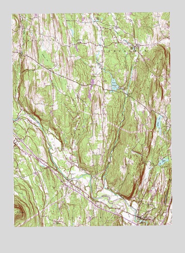
Leeds, NY USGS Topographic Map
Click on map above to begin viewing in our Map Viewer.

This topographic map contains these locations and features:
Feature Name Type Latitude Longitude GNIS ID View Map
Athens Village Water Treatment PlantLocaleN42.3126°W73.8824°2617698View Map
Bell BrookStreamN42.2773°W73.9535°943583View Map
Blackman CemeteryCemeteryN42.2807°W73.9541°944201View Map
Brookside Green Mobile Home ParkPopulated PlaceN42.2615°W73.9630°2618207View Map
Butler CemeteryCemeteryN42.3330°W73.9376°945339View Map
CairoPopulated PlaceN42.2990°W73.9985°945440View Map
Cairo Elementary SchoolSchoolN42.2986°W73.9966°2668817View Map
Cairo Hose CompanyBuildingN42.3006°W73.9987°2735017View Map
Cairo JunctionPopulated PlaceN42.2531°W73.9665°972290View Map
Cairo Public LibraryBuildingN42.3005°W73.9998°2617237View Map
Cairo Round TopSummitN42.2590°W73.9974°969947View Map
Canoe LakeLakeN42.2675°W73.8791°945785View Map
Catskill Valley AirparkAirportN42.2795°W73.9526°978308View Map
Cedaridge FarmLocaleN42.2503°W73.9128°2547714View Map
Cob CreekStreamN42.3276°W73.9096°946952View Map
Dots LakeLakeN42.3709°W73.9328°948594View Map
EarltonPopulated PlaceN42.3556°W73.9007°948956View Map
Earlton Volunteer Fire DepartmentBuildingN42.3550°W73.9015°2735018View Map
Feddes Mobile Home ParkPopulated PlaceN42.2642°W73.9272°2496644View Map
Forrest Hills Mobile Home ParkPopulated PlaceN42.2614°W73.9300°2618224View Map
GayheadPopulated PlaceN42.3415°W73.9701°950958View Map
Gayhead CemeteryCemeteryN42.3446°W73.9657°2547531View Map
Gayhead VlySwampN42.3484°W73.9735°950960View Map
Grapeville CreekStreamN42.3495°W73.9015°951531View Map
Greens LakeLakeN42.2874°W73.8817°951766View Map
Hollister LakeLakeN42.3092°W73.8844°953002View Map
Honey Hollow CemeteryCemeteryN42.3662°W73.9164°953144View Map
Indian RidgeRidgeN42.3154°W73.9346°953691View Map
Jan De Bakkers KillStreamN42.3168°W73.9887°970245View Map
Lakes Mills BridgeBridgeN42.3137°W73.9960°954961View Map
LeedsPopulated PlaceN42.2554°W73.9024°955168View Map
Leeds Census Designated PlaceCensusN42.2529°W73.8940°2390049View Map
Leeds Fire Department Hose Company 1BuildingN42.2540°W73.8944°2718610View Map
Leeds FlatFlatN42.2590°W73.9124°955169View Map
Leeds Post OfficePost OfficeN42.2551°W73.9030°2617999View Map
Leeds Reformed ChurchChurchN42.2549°W73.9004°2616639View Map
Leeds Village CemeteryCemeteryN42.2565°W73.9027°2547532View Map
LimestreetPopulated PlaceN42.3084°W73.8757°955356View Map
Mill PondLakeN42.2526°W73.9001°957266View Map
Mill PondLakeN42.3539°W73.9040°957267View Map
Palmer CemeteryCemeteryN42.3572°W73.9555°959783View Map
Place CornersPopulated PlaceN42.3670°W73.9915°972952View Map
Potic CreekStreamN42.2665°W73.9146°961028View Map
Potic MountainSummitN42.3131°W73.8971°961029View Map
Potic Reservoir Water Treatment PlantLocaleN42.3303°W73.9128°2617750View Map
Potuck ReservoirReservoirN42.3327°W73.9194°961056View Map
ResultPopulated PlaceN42.3570°W73.9479°962410View Map
Sacred Heart ChurchChurchN42.2973°W73.9981°2616857View Map
Saint Therasas ChapelChurchN42.2837°W73.8826°964234View Map
Sandy PlainFlatN42.2915°W73.9643°964434View Map
Sandy Plain CemeteryCemeteryN42.2884°W73.9534°964435View Map
Schnares Sunset OrchardsLocaleN42.3608°W73.8764°2547720View Map
School Number 10 (historical)SchoolN42.2825°W73.9297°2466147View Map
School Number 11 (historical)SchoolN42.3569°W73.9611°2466108View Map
School Number 12 (historical)SchoolN42.3678°W73.9933°2466107View Map
School Number 14 (historical)SchoolN42.2544°W73.9728°2466165View Map
School Number 14 (historical)SchoolN42.3431°W73.9717°2466145View Map
School Number 2 (historical)SchoolN42.3661°W73.9244°2466125View Map
School Number 3 (historical)SchoolN42.3181°W73.8922°2466186View Map
School Number 5 (historical)SchoolN42.2842°W73.8839°2466185View Map
School Number 7 (historical)SchoolN42.2925°W73.9600°2466146View Map
School Number 8 (historical)SchoolN42.3578°W73.8856°2466187View Map
School Number 9 (historical)SchoolN42.3348°W73.9287°975620View Map
Shingle KillStreamN42.3123°W73.9985°965120View Map
South CairoPopulated PlaceN42.2770°W73.9568°965717View Map
South Cairo Post OfficePost OfficeN42.2751°W73.9545°2618132View Map
Three Town BridgeBridgeN42.3270°W73.9093°967466View Map
Union CemeteryCemeteryN42.3281°W73.9271°968153View Map
Waldron Brandow CemeteryCemeteryN42.3590°W73.9493°968670View Map
Waldron CemeteryCemeteryN42.3719°W73.9836°968666View Map
Webber CemeteryCemeteryN42.3380°W73.9373°968979View Map
Weekes CemeteryCemeteryN42.3101°W73.9349°969009View Map
West Medway CreekStreamN42.3729°W73.9185°970795View Map

Note: Coordinates in the location and feature list above are referenced to NAD83 datum.


Copyright (C) 2008-2024 Ryan Niemi / Sunset Dynamics ... All Rights Reserved