TopoQuest Logo
Do you find TopoQuest useful?
Help keep TopoQuest running and adding new maps/features by donating!
Bitcoin:  19c7KJd3qBynnjoSw5npx9KScwjBe4ifkT
Litecoin:  LXs6TkuXGGXo1vDsWCkWVdjQX94eUKd6ui
Home View Maps Find Maps Find Places Resources & Links


Cameron, Mississippi Topographic Map

USGS Map Title: Cameron, MS
USGS Map MRC: 32089G8
DRG (GeoTIFF) Download: o32089g8.tif


Neighboring USGS Topographic Map Quads:


  Ebenezer, MS  
32090H1
 

  Goodman, MS  
32089H8
 

  Newport, MS  
32089H7
 

  Vaughan, MS  
32090G1
 

  Cameron, MS  
32089G8
 

  Camden, MS  
32089G7
 

  Way, MS  
32090F1
 

  Sharon, MS  
32089F8
 

  Farmhaven, MS  
32089F7


Map MRC Location:

N33°
W90°
N33°
W89°
H8 H7 H6 H5 H4 H3 H2 H1
G8 G7 G6 G5 G4 G3 G2 G1
F8 F7 F6 F5 F4 F3 F2 F1
E8 E7 E6 E5 E4 E3 E2 E1
D8 D7 D6 D5 D4 D3 D2 D1
C8 C7 C6 C5 C4 C3 C2 C1
B8 B7 B6 B5 B4 B3 B2 B1
A8 A7 A6 A5 A4 A3 A2 A1
N32°
W90°
N32°
W89°

Cameron, MS USGS 1:24K Topographic Map Preview:
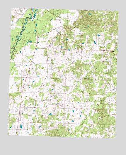
Cameron, MS USGS Topographic Map
Click on map above to begin viewing in our Map Viewer.

This topographic map contains these locations and features:
Feature Name Type Latitude Longitude GNIS ID View Map
A B Mansell Lake DamDamN32.7718°W89.9151°681640View Map
Andrews ChapelChurchN32.8137°W89.8856°666269View Map
Andrews Chapel CemeteryCemeteryN32.8140°W89.8858°2042936View Map
Bear CreekStreamN32.8496°W89.9884°666643View Map
Bethel ChurchChurchN32.8362°W89.9504°666923View Map
Bethel Church CemeteryCemeteryN32.8362°W89.9504°2042941View Map
Bethel SchoolSchoolN32.8357°W89.9565°666964View Map
Blue HoleLakeN32.8426°W89.9773°667293View Map
C C Lord Lake DamDamN32.7968°W89.9501°681660View Map
CameronPopulated PlaceN32.8357°W89.8840°667958View Map
Concord CemeteryCemeteryN32.7847°W89.9692°2039981View Map
Concord ChurchChurchN32.7846°W89.9684°668739View Map
Dickson CemeteryCemeteryN32.7787°W89.9187°669265View Map
E M Billingslea Lake DamDamN32.7718°W89.9234°681641View Map
Evening Star ChurchChurchN32.8746°W89.9098°669842View Map
Frank Cauthen Lake DamDamN32.8385°W89.9401°681690View Map
Free Union ChurchChurchN32.8576°W89.9192°670190View Map
Free Union Church CemeteryCemeteryN32.8621°W89.9198°2042963View Map
H T Stubbs Lake DamDamN32.8501°W89.8967°681700View Map
Herrods Box (historical)LocaleN32.7657°W89.9979°683243View Map
J H Fowler Lake DamDamN32.8168°W89.9151°681672View Map
J K Simpson LakeDamN32.8451°W89.9184°681696View Map
J N Brown Lake DamDamN32.7818°W89.9818°681647View Map
Jack LakeLakeN32.8711°W89.9492°671759View Map
James Duncan Lake DamDamN32.7585°W89.9851°681629View Map
Joe Cauthen Lake DamDamN32.8418°W89.9017°681693View Map
LoringPopulated PlaceN32.7804°W89.9379°692020View Map
Loves CreekStreamN32.8315°W89.9984°672906View Map
Martin Family CemeteryCemeteryN32.7710°W89.9729°2042996View Map
Martin Presley Lake DamDamN32.7968°W89.9751°681661View Map
Mary Magdalene ChurchChurchN32.7776°W89.9081°673213View Map
Morning Star ChurchChurchN32.7704°W89.9770°673833View Map
OaksPopulated PlaceN32.7999°W89.9770°692121View Map
Pickens Oil FieldOilfieldN32.8251°W89.9904°675703View Map
Rock Hill ChurchChurchN32.8076°W89.9092°676759View Map
Rocky Hill Methodist Church CemeteryCemeteryN32.8080°W89.9090°2043027View Map
Saint Matthew ChurchChurchN32.8071°W89.9768°677164View Map
Saint Peter ChurchChurchN32.7779°W89.9356°677230View Map
Saint Peters Church CemeteryCemeteryN32.7775°W89.9356°2043048View Map
Sharp Plantation (historical)LocaleN32.7571°W89.9904°686127View Map
SharpsburgPopulated PlaceN32.7560°W89.9895°692222View Map
Sharpsburg CemeteryCemeteryN32.7562°W89.9896°2043034View Map
Soule ChapelChurchN32.7996°W89.9484°677987View Map
Soule Chapel CemeteryCemeteryN32.7998°W89.9484°2043041View Map
Spring BranchStreamN32.8382°W89.9840°678074View Map
TruittPopulated PlaceN32.8071°W89.9090°692277View Map
W S Billingslea Lake DamDamN32.7818°W89.9601°681646View Map
W S Billingsly Lake DamDamN32.7651°W89.9234°681633View Map
W W Billingsly Lake DamDamN32.7718°W89.9518°681642View Map
Williamson Family CemeteryCemeteryN32.7754°W89.9741°2043064View Map

Note: Coordinates in the location and feature list above are referenced to NAD83 datum.


Copyright (C) 2008-2024 Ryan Niemi / Sunset Dynamics ... All Rights Reserved