TopoQuest Logo
Do you find TopoQuest useful?
Help keep TopoQuest running and adding new maps/features by donating!
Bitcoin:  19c7KJd3qBynnjoSw5npx9KScwjBe4ifkT
Litecoin:  LXs6TkuXGGXo1vDsWCkWVdjQX94eUKd6ui
Home View Maps Find Maps Find Places Resources & Links


Goodman, Mississippi Topographic Map

USGS Map Title: Goodman, MS
USGS Map MRC: 32089H8
DRG (GeoTIFF) Download: o32089h8.tif


Neighboring USGS Topographic Map Quads:


  Lexington South, MS  
33090A1
 

  Owens Wells, MS  
33089A8
 

  Durant, MS  
33089A7
 

  Ebenezer, MS  
32090H1
 

  Goodman, MS  
32089H8
 

  Newport, MS  
32089H7
 

  Vaughan, MS  
32090G1
 

  Cameron, MS  
32089G8
 

  Camden, MS  
32089G7


Map MRC Location:

N33°
W90°
N33°
W89°
H8 H7 H6 H5 H4 H3 H2 H1
G8 G7 G6 G5 G4 G3 G2 G1
F8 F7 F6 F5 F4 F3 F2 F1
E8 E7 E6 E5 E4 E3 E2 E1
D8 D7 D6 D5 D4 D3 D2 D1
C8 C7 C6 C5 C4 C3 C2 C1
B8 B7 B6 B5 B4 B3 B2 B1
A8 A7 A6 A5 A4 A3 A2 A1
N32°
W90°
N32°
W89°

Goodman, MS USGS 1:24K Topographic Map Preview:
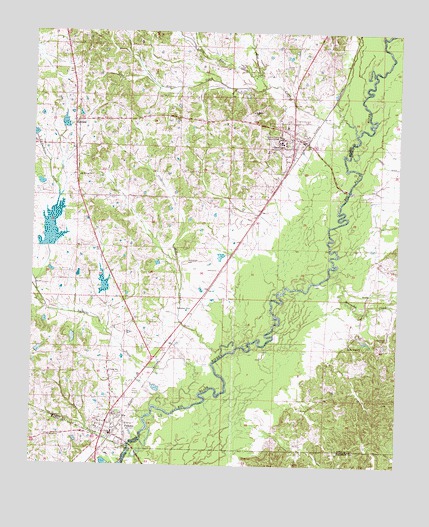
Goodman, MS USGS Topographic Map
Click on map above to begin viewing in our Map Viewer.

This topographic map contains these locations and features:
Feature Name Type Latitude Longitude GNIS ID View Map
Bethlehem CemeteryCemeteryN32.9340°W89.9481°666979View Map
Bethlehem ChurchChurchN32.9204°W89.9468°667002View Map
Box CreekStreamN32.9712°W89.8904°667487View Map
Bridgeforth Lake DamDamN32.8751°W89.9751°681718View Map
Falls CemeteryCemeteryN32.9537°W89.9745°669904View Map
GoodmanPopulated PlaceN32.9701°W89.9123°670500View Map
Goodman Attendance CenterSchoolN32.9732°W89.9140°706628View Map
Goodman Police DepartmentBuildingN32.9687°W89.9077°2754094View Map
Goodman Post OfficePost OfficeN32.9689°W89.9077°2768855View Map
Goodman Volunteer Fire DepartmentBuildingN32.9681°W89.9078°2665786View Map
Goodman-Pickens Elementary SchoolSchoolN32.9290°W89.9393°706629View Map
Green CemeteryCemeteryN32.9896°W89.9140°670654View Map
Greens CreekStreamN32.9843°W89.9229°670706View Map
Hillcrest CemeteryCemeteryN32.9748°W89.9115°671215View Map
Holmes Junior CollegeSchoolN32.9696°W89.9165°671351View Map
Holmes Junior College Lake DamDamN32.9718°W89.9201°681767View Map
Interchange 144CrossingN32.9410°W89.9790°691441View Map
Interchange 146CrossingN32.9754°W89.9637°691442View Map
Little Box CreekStreamN32.9879°W89.9254°672555View Map
Mills CreekStreamN32.9068°W89.9348°673656View Map
Millsaps (historical)LocaleN32.9112°W89.9487°706663View Map
Mississippi No Name 30 DamDamN32.9735°W89.9884°681769View Map
Mississippi No Name 34 DamDamN32.9301°W89.9384°681742View Map
Mitchell CemeteryCemeteryN32.9123°W89.8790°673705View Map
Moore Family CemeteryCemeteryN32.9145°W89.9639°2043004View Map
Mount Moriah ChurchChurchN32.9585°W89.9845°674067View Map
Peterson AirportAirportN32.9440°W89.9285°2676428View Map
PickensPopulated PlaceN32.8837°W89.9715°675699View Map
Pickens Attendance CenterSchoolN32.8874°W89.9765°706675View Map
Pickens CemeteryCemeteryN32.8882°W89.9698°706676View Map
Pickens Police DepartmentBuildingN32.8875°W89.9740°2754132View Map
Pickens Post OfficePost OfficeN32.8858°W89.9724°2768841View Map
Pickens Sewage Lagoon DamDamN32.8918°W89.9634°681730View Map
Pickens Volunteer Fire DepartmentBuildingN32.8867°W89.9731°2665669View Map
Presleys Airport (historical)AirportN32.8960°W89.9668°680359View Map
Quiet Ridge CemeteryCemeteryN32.8877°W89.9702°676433View Map
RichlandPopulated PlaceN32.9743°W89.9865°676637View Map
Saint Marys ChurchChurchN32.9768°W89.9265°677154View Map
Saint Peters ChurchChurchN32.8832°W89.9937°677241View Map
Seneasha CreekStreamN32.9301°W89.8987°677516View Map
Spring Ridge ChurchChurchN32.9101°W89.8915°678159View Map
Spring Ridge School (historical)SchoolN32.9099°W89.8917°711013View Map
Tackett Watershed 6 DamDamN32.9251°W89.9751°681741View Map
Tackett Watershed 9 DamDamN32.9368°W89.9918°681748View Map
Tacketts CreekStreamN32.8912°W89.9498°678537View Map
Town CreekStreamN32.8796°W89.9662°678834View Map
Town of GoodmanCivilN32.9677°W89.9128°2406588View Map
Town of PickensCivilN32.8913°W89.9697°2407106View Map
Union SchoolSchoolN32.9021°W89.9731°679112View Map
Valena (historical)Populated PlaceN32.9543°W89.8834°711031View Map
Williams Ferry (historical)CrossingN32.9662°W89.8920°688186View Map
WVTH-FM (Goodman)TowerN32.9701°W89.9168°680229View Map

Note: Coordinates in the location and feature list above are referenced to NAD83 datum.


Copyright (C) 2008-2024 Ryan Niemi / Sunset Dynamics ... All Rights Reserved