TopoQuest Logo
Do you find TopoQuest useful?
Help keep TopoQuest running and adding new maps/features by donating!
Bitcoin:  19c7KJd3qBynnjoSw5npx9KScwjBe4ifkT
Litecoin:  LXs6TkuXGGXo1vDsWCkWVdjQX94eUKd6ui
Home View Maps Find Maps Find Places Resources & Links


Durant, Mississippi Topographic Map

USGS Map Title: Durant, MS
USGS Map MRC: 33089A7
DRG (GeoTIFF) Download: o33089a7.tif


Neighboring USGS Topographic Map Quads:


  Bowling Green, MS  
33089B8
 

  West, MS  
33089B7
 

  Hesterville, MS  
33089B6
 

  Owens Wells, MS  
33089A8
 

  Durant, MS  
33089A7
 

  McAdams, MS  
33089A6
 

  Goodman, MS  
32089H8
 

  Newport, MS  
32089H7
 

  Joseph, MS  
32089H6


Map MRC Location:

N34°
W90°
N34°
W89°
H8 H7 H6 H5 H4 H3 H2 H1
G8 G7 G6 G5 G4 G3 G2 G1
F8 F7 F6 F5 F4 F3 F2 F1
E8 E7 E6 E5 E4 E3 E2 E1
D8 D7 D6 D5 D4 D3 D2 D1
C8 C7 C6 C5 C4 C3 C2 C1
B8 B7 B6 B5 B4 B3 B2 B1
A8 A7 A6 A5 A4 A3 A2 A1
N33°
W90°
N33°
W89°

Durant, MS USGS 1:24K Topographic Map Preview:
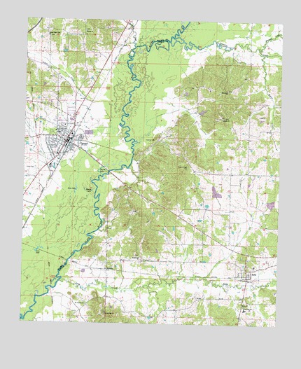
Durant, MS USGS Topographic Map
Click on map above to begin viewing in our Map Viewer.

This topographic map contains these locations and features:
Feature Name Type Latitude Longitude GNIS ID View Map
Apookta CreekStreamN33.1162°W89.8042°666342View Map
Attalaville (historical)Populated PlaceN33.0099°W89.7890°710826View Map
Barlow African Methodist Episcopal ChurchChurchN33.0082°W89.7667°690953View Map
Belmont ChurchChurchN33.1207°W89.8459°666810View Map
Bowlin (historical)Populated PlaceN33.0849°W89.7765°710842View Map
Bowlin Baptist ChurchChurchN33.0846°W89.7781°667476View Map
Bowlin CemeteryCemeteryN33.0851°W89.7779°691048View Map
Bowlin School (historical)SchoolN33.0851°W89.7784°710843View Map
BoyettePopulated PlaceN33.0221°W89.8331°667498View Map
Boyette School (historical)SchoolN33.0321°W89.8329°710844View Map
Bunker Hill CemeteryCemeteryN33.0285°W89.8181°710849View Map
Bunker Hill ChurchChurchN33.0274°W89.8176°667791View Map
Bunker Hill School (historical)SchoolN33.0340°W89.8209°710850View Map
City of DurantCivilN33.0799°W89.8566°2403520View Map
Crooker Mill (historical)LocaleN33.0571°W89.7601°690016View Map
District Two Community HospitalHospitalN33.0815°W89.8554°706610View Map
DurantPopulated PlaceN33.0751°W89.8545°669521View Map
Durant Attendance CenterSchoolN33.0782°W89.8581°706613View Map
Durant CemeteryCemeteryN33.0637°W89.8695°669522View Map
Durant CemeteryCemeteryN33.0671°W89.8584°706614View Map
Durant Fire DepartmentBuildingN33.0755°W89.8554°2665694View Map
Durant Lagoon DamDamN33.0818°W89.8467°681837View Map
Durant Police DepartmentBuildingN33.0755°W89.8554°2754189View Map
Durant Post OfficePost OfficeN33.0742°W89.8554°2768830View Map
Durant SchoolSchoolN33.0649°W89.8623°669523View Map
Holeman CemeteryCemeteryN33.0757°W89.8109°671284View Map
Howard CreekStreamN33.1140°W89.8215°671532View Map
Indian CreekStreamN33.0776°W89.8301°671689View Map
Jack LakeLakeN33.0298°W89.8678°671760View Map
Jericho ChurchChurchN33.0429°W89.7734°671847View Map
Jericho Church (historical)ChurchN33.0437°W89.7745°710900View Map
Long CreekStreamN33.0168°W89.8567°672820View Map
Long Creek Elementary SchoolSchoolN33.0062°W89.7659°711609View Map
Long Creek Watershed 3 DamDamN33.0518°W89.7817°681816View Map
Long Creek Watershed Structure 4 DamDamN33.0335°W89.7667°681798View Map
Macedonia ChurchChurchN33.0957°W89.7759°673035View Map
Macedonia School (historical)SchoolN33.0960°W89.7765°710919View Map
Melton CemeteryCemeteryN33.1154°W89.8512°706660View Map
Mount Pleasant African Methodist Episcopal ChurchChurchN33.0079°W89.8437°674253View Map
Mount Pleasant CemeteryCemeteryN33.0079°W89.8440°710935View Map
Pleasant Ridge CemeteryCemeteryN33.0640°W89.7954°690932View Map
Round LakeLakeN33.0545°W89.8417°676911View Map
SallisPopulated PlaceN33.0224°W89.7654°677299View Map
Sallis Baptist ChurchChurchN33.0199°W89.7631°710992View Map
Sallis CemeteryCemeteryN33.0246°W89.7645°710993View Map
Sallis Post OfficePost OfficeN33.0195°W89.7656°2768769View Map
Sallis SchoolSchoolN33.0243°W89.7615°710994View Map
Second Pilgrim Rest ChurchChurchN33.1182°W89.8637°677492View Map
Sharkey CreekStreamN33.1143°W89.7609°677614View Map
Sims LakeLakeN33.0547°W89.8494°677837View Map
Spring LakeLakeN33.0641°W89.8370°678150View Map
Stump Ridge CemeteryCemeteryN33.0043°W89.8342°711019View Map
Stump Ridge ChurchChurchN33.0040°W89.8342°690936View Map
Taylor CreekStreamN33.1112°W89.7590°678595View Map
Town of SallisCivilN33.0216°W89.7647°2407278View Map

Note: Coordinates in the location and feature list above are referenced to NAD83 datum.


Copyright (C) 2008-2024 Ryan Niemi / Sunset Dynamics ... All Rights Reserved