TopoQuest Logo
Do you find TopoQuest useful?
Help keep TopoQuest running and adding new maps/features by donating!
Bitcoin:  19c7KJd3qBynnjoSw5npx9KScwjBe4ifkT
Litecoin:  LXs6TkuXGGXo1vDsWCkWVdjQX94eUKd6ui
Home View Maps Find Maps Find Places Resources & Links


Wild River, New Hampshire Topographic Map

USGS Map Title: Wild River, NH
USGS Map MRC: 44071C1
DRG (GeoTIFF) Download: o44071c1.tif


Neighboring USGS Topographic Map Quads:


  Berlin, NH  
44071D2
 

  Shelburne, NH  
44071D1
 

  Gilead, ME  
44070D8
 

  Carter Dome, NH  
44071C2
 

  Wild River, NH  
44071C1
 

  Speckled Mountain, ME  
44070C8
 

  Jackson, NH  
44071B2
 

  Chatham, NH  
44071B1
 

  Center Lovell, ME  
44070B8


Map MRC Location:

N45°
W72°
N45°
W71°
H8 H7 H6 H5 H4 H3 H2 H1
G8 G7 G6 G5 G4 G3 G2 G1
F8 F7 F6 F5 F4 F3 F2 F1
E8 E7 E6 E5 E4 E3 E2 E1
D8 D7 D6 D5 D4 D3 D2 D1
C8 C7 C6 C5 C4 C3 C2 C1
B8 B7 B6 B5 B4 B3 B2 B1
A8 A7 A6 A5 A4 A3 A2 A1
N44°
W72°
N44°
W71°

Wild River, NH USGS 1:24K Topographic Map Preview:
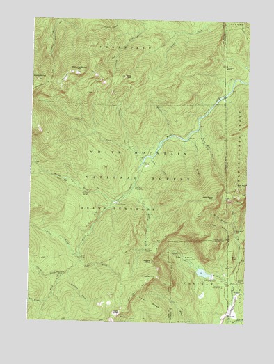
Wild River, NH USGS Topographic Map
Click on map above to begin viewing in our Map Viewer.

This topographic map contains these locations and features:
Feature Name Type Latitude Longitude GNIS ID View Map
Baldface BrookStreamN44.2701°W71.1023°871438View Map
Baldface Circle TrailTrailN44.2512°W71.0620°871439View Map
Basin BrookStreamN44.2678°W71.0081°580926View Map
Basin Brook ReservoirReservoirN44.2710°W71.0240°1775612View Map
Basin Campground and Picnic AreaLocaleN44.2681°W71.0217°873110View Map
Basin Pond CampgroundLocaleN44.2681°W71.0215°1915878View Map
Basin Rim TrailTrailN44.2790°W71.0512°871454View Map
Basin TrailTrailN44.2959°W71.0567°871455View Map
Beans PurchaseCivilN44.2889°W71.1185°871460View Map
Bickford BrookStreamN44.2634°W71.0065°580934View Map
Birch KnollSummitN44.2777°W71.0074°580938View Map
Blue BrookStreamN44.3076°W71.0637°871537View Map
Blue Brook ShelterLocaleN44.2803°W71.0567°871538View Map
Brickett FallsFallsN44.2506°W71.0317°871578View Map
Brickett PlacePopulated PlaceN44.2676°W71.0042°580953View Map
Brickett Place Organization CampLocaleN44.2709°W71.0120°873109View Map
Bull BrookStreamN44.3173°W71.0590°871589View Map
Burnt Mill BrookStreamN44.3315°W71.0273°871595View Map
Burnt Mill Brook TrailTrailN44.3148°W71.0179°871596View Map
Carlton NotchGapN44.3556°W71.0129°580973View Map
Cedar BrookStreamN44.2751°W71.0951°871649View Map
Cold River CampgroundLocaleN44.2651°W71.0131°871713View Map
Cypress BrookStreamN44.2806°W71.0954°871758View Map
Dewdrop BrookStreamN44.3262°W71.0334°871782View Map
Eagle CragPillarN44.2537°W71.0717°871820View Map
Eagle Link TrailTrailN44.2509°W71.0929°871822View Map
East Royce MountainSummitN44.3074°W71.0056°581007View Map
East Royce TrailTrailN44.3042°W71.0026°581008View Map
Hermit FallsFallsN44.2787°W71.0387°872034View Map
Highwater TrailTrailN44.3520°W71.0081°581059View Map
Highwater TrailTrailN44.2928°W71.0870°872040View Map
Howe PeakSummitN44.3517°W71.0704°872055View Map
Kenduskeag TrailTrailN44.3528°W71.1040°872133View Map
Laughing Lion TrailTrailN44.2981°W71.0026°581092View Map
Mad RiverStreamN44.2853°W71.0048°581109View Map
Mad River FallsFallsN44.2884°W71.0062°581110View Map
Martins BrookStreamN44.3276°W71.0431°872258View Map
Meader Ridger TrailTrailN44.2626°W71.0626°873108View Map
Middle Branch Mad RiverStreamN44.2906°W71.0073°581124View Map
Middle Moriah MountainSummitN44.3498°W71.1212°872290View Map
Moriah BrookStreamN44.2998°W71.0765°872326View Map
Moriah Brook TrailTrailN44.3067°W71.0984°872328View Map
Moriah GeorgeGapN44.3037°W71.0915°872329View Map
Mount MeaderSummitN44.2692°W71.0537°872271View Map
Mount Meader TrailTrailN44.2584°W71.0379°872346View Map
Pine BrookStreamN44.3509°W71.0076°873106View Map
Ragged JacketSummitN44.2753°W71.0542°872536View Map
Rattle River TrailTrailN44.3715°W71.1115°872540View Map
Red BrookStreamN44.2584°W71.1142°872550View Map
Rim JunctionPopulated PlaceN44.2831°W71.0495°872571View Map
Royce TrailTrailN44.2823°W71.0037°581197View Map
Shelburne Moriah MountainSummitN44.3528°W71.0987°872647View Map
Shelburne TrailTrailN44.3548°W71.0767°872648View Map
Site 1 Basin Brook DamDamN44.2701°W71.0195°1775611View Map
South Branch Mad RiverStreamN44.2862°W71.0062°581213View Map
Spider BridgeBridgeN44.2767°W71.0951°872712View Map
Spruce BrookStreamN44.2684°W71.1059°872716View Map
Spruce Brook ShelterLocaleN44.2692°W71.1062°873107View Map
The BasinBasinN44.2776°W71.0356°872781View Map
Twin BrookStreamN44.3184°W71.0537°872841View Map
Walker RidgeRidgeN44.2573°W71.0548°872860View Map
West Royce MountainSummitN44.3020°W71.0181°872897View Map
Wild River CampgroundLocaleN44.3056°W71.0634°872936View Map
Wild River Climatic StationLocaleN44.2998°W71.0751°873278View Map
Wild River TrailTrailN44.2731°W71.0979°872937View Map
Wild River WildernessReserveN44.2889°W71.1140°2767385View Map

Note: Coordinates in the location and feature list above are referenced to NAD83 datum.


Copyright (C) 2008-2024 Ryan Niemi / Sunset Dynamics ... All Rights Reserved