TopoQuest Logo
Do you find TopoQuest useful?
Help keep TopoQuest running and adding new maps/features by donating!
Bitcoin:  19c7KJd3qBynnjoSw5npx9KScwjBe4ifkT
Litecoin:  LXs6TkuXGGXo1vDsWCkWVdjQX94eUKd6ui
Home View Maps Find Maps Find Places Resources & Links


Warwick, Georgia Topographic Map

USGS Map Title: Warwick, GA
USGS Map MRC: 31083G8
DRG (GeoTIFF) Download: o31083g8.tif


Neighboring USGS Topographic Map Quads:


  Leslie, GA  
31084H1
 

  Cobb, GA  
31083H8
 

  Cordele, GA  
31083H7
 

  Leslie SE, GA  
31084G1
 

  Warwick, GA  
31083G8
 

  Pateville, GA  
31083G7
 

  Albany NE, GA  
31084F1
 

  Doles, GA  
31083F8
 

  Cuffietown, GA  
31083F7


Map MRC Location:

N32°
W84°
N32°
W83°
H8 H7 H6 H5 H4 H3 H2 H1
G8 G7 G6 G5 G4 G3 G2 G1
F8 F7 F6 F5 F4 F3 F2 F1
E8 E7 E6 E5 E4 E3 E2 E1
D8 D7 D6 D5 D4 D3 D2 D1
C8 C7 C6 C5 C4 C3 C2 C1
B8 B7 B6 B5 B4 B3 B2 B1
A8 A7 A6 A5 A4 A3 A2 A1
N31°
W84°
N31°
W83°

Warwick, GA USGS 1:24K Topographic Map Preview:
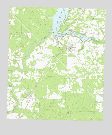
Warwick, GA USGS Topographic Map
Click on map above to begin viewing in our Map Viewer.

This topographic map contains these locations and features:
Feature Name Type Latitude Longitude GNIS ID View Map
Asbury Church (historical)ChurchN31.8496°W83.9163°344075View Map
Aultman Still (historical)LocaleN31.7524°W83.8896°343250View Map
Bethlehem ChurchChurchN31.8749°W83.9055°354665View Map
Blue Springs ChurchChurchN31.7641°W83.9205°354788View Map
Bridges Community CenterBuildingN31.8513°W83.8838°334962View Map
Burke Ferry (historical)CrossingN31.8496°W83.9455°343265View Map
Cedar Creek Primitive Baptist ChurchChurchN31.8732°W83.9038°355051View Map
Cedar Creek School (historical)SchoolN31.8732°W83.9038°334967View Map
Chokee CreekStreamN31.8360°W83.9660°312651View Map
City of WarwickCivilN31.8298°W83.9206°2405679View Map
Crisp County DamDamN31.8480°W83.9416°337193View Map
Crisp County Hydro-Electric PlantLocaleN31.8474°W83.9421°344221View Map
Davis MillPopulated PlaceN31.7588°W83.9196°326243View Map
Flournoy BranchStreamN31.8430°W83.9374°314237View Map
Fords Still (historical)LocaleN31.7543°W83.9563°343284View Map
Fort Early (historical)MilitaryN31.8592°W83.9283°344076View Map
Fort Early CemeteryCemeteryN31.8288°W83.9293°349384View Map
Fort Early ChurchChurchN31.8288°W83.9293°314289View Map
Fort Early MonumentParkN31.8593°W83.9282°334998View Map
Franns BridgeBridgeN31.8385°W83.8835°334999View Map
Hanna BranchStreamN31.8496°W83.9249°315089View Map
Jones CreekStreamN31.7593°W83.9899°316231View Map
Jordan Company LakeReservoirN31.7593°W83.9171°338340View Map
Jordan Company Lake DamDamN31.7602°W83.9199°338339View Map
Lake BlackshearReservoirN31.8371°W83.9352°311506View Map
Loron William ParkParkN31.8546°W83.9335°317411View Map
MarshallPopulated PlaceN31.8685°W83.8882°332324View Map
Mill BranchStreamN31.8421°W83.9027°343307View Map
Mount Asia Church (historical)ChurchN31.8530°W83.8899°335016View Map
New Hope ChurchChurchN31.7699°W83.8885°343314View Map
New Union CemeteryCemeteryN31.7593°W83.8871°349396View Map
New Union ChurchChurchN31.7593°W83.8877°319552View Map
New York (historical)Populated PlaceN31.8135°W83.9993°343396View Map
OakfieldPopulated PlaceN31.7780°W83.9713°332541View Map
Oakfield CemeteryCemeteryN31.7793°W83.9657°349398View Map
Oakfield CemeteryCemeteryN31.7763°W83.9727°349399View Map
Pindertown (historical)Populated PlaceN31.7524°W83.9888°343322View Map
Saint Regis Landing Strip (historical)AirportN31.7541°W83.9180°343334View Map
Smoak BridgeBridgeN31.8468°W83.9185°323166View Map
Smoak CemeteryCemeteryN31.8493°W83.9171°323167View Map
Starr FarmLocaleN31.7691°W83.9938°343404View Map
Storey Still (historical)LocaleN31.8271°W83.9099°343343View Map
Swift CreekStreamN31.8449°W83.9341°323845View Map
The Bay BranchStreamN31.8388°W83.9680°324036View Map
WarwickPopulated PlaceN31.8310°W83.9188°333371View Map
Warwick CemeteryCemeteryN31.8263°W83.9213°349411View Map
Warwick High SchoolSchoolN31.8263°W83.9180°343358View Map
Warwick Police DepartmentBuildingN31.8292°W83.9200°2733552View Map
Warwick United Methodist ChurchChurchN31.8268°W83.9216°349412View Map
Warwick Volunteer Fire Department Station 14BuildingN31.8300°W83.9195°2604785View Map
Worth County Emergency Medical ServicesBuildingN31.8298°W83.9195°2625449View Map

Note: Coordinates in the location and feature list above are referenced to NAD83 datum.


Copyright (C) 2008-2024 Ryan Niemi / Sunset Dynamics ... All Rights Reserved