TopoQuest Logo
Do you find TopoQuest useful?
Help keep TopoQuest running and adding new maps/features by donating!
Bitcoin:  19c7KJd3qBynnjoSw5npx9KScwjBe4ifkT
Litecoin:  LXs6TkuXGGXo1vDsWCkWVdjQX94eUKd6ui
Home View Maps Find Maps Find Places Resources & Links


Doles, Georgia Topographic Map

USGS Map Title: Doles, GA
USGS Map MRC: 31083F8
DRG (GeoTIFF) Download: o31083f8.tif


Neighboring USGS Topographic Map Quads:


  Leslie SE, GA  
31084G1
 

  Warwick, GA  
31083G8
 

  Pateville, GA  
31083G7
 

  Albany NE, GA  
31084F1
 

  Doles, GA  
31083F8
 

  Cuffietown, GA  
31083F7
 

  Albany East, GA  
31084E1
 

  Acree, GA  
31083E8
 

  Sylvester, GA  
31083E7


Map MRC Location:

N32°
W84°
N32°
W83°
H8 H7 H6 H5 H4 H3 H2 H1
G8 G7 G6 G5 G4 G3 G2 G1
F8 F7 F6 F5 F4 F3 F2 F1
E8 E7 E6 E5 E4 E3 E2 E1
D8 D7 D6 D5 D4 D3 D2 D1
C8 C7 C6 C5 C4 C3 C2 C1
B8 B7 B6 B5 B4 B3 B2 B1
A8 A7 A6 A5 A4 A3 A2 A1
N31°
W84°
N31°
W83°

Doles, GA USGS 1:24K Topographic Map Preview:
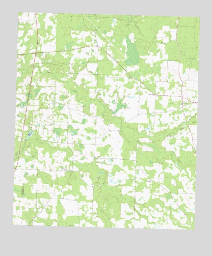
Doles, GA USGS Topographic Map
Click on map above to begin viewing in our Map Viewer.

This topographic map contains these locations and features:
Feature Name Type Latitude Longitude GNIS ID View Map
Abrams School (historical)SchoolN31.6730°W83.8768°343247View Map
Aultmans (historical)Populated PlaceN31.6849°W83.9263°343251View Map
Blue SpringSpringN31.6560°W83.9413°343256View Map
Blue Spring (historical)Populated PlaceN31.6835°W83.9277°343255View Map
Buckaloo School (historical)SchoolN31.7421°W83.9516°343264View Map
Camp OsbornLocaleN31.6538°W83.9421°312247View Map
Charity Grove ChurchChurchN31.7038°W83.9046°312574View Map
Charity Grove School (historical)SchoolN31.7038°W83.9049°343268View Map
Davis School (historical)SchoolN31.6468°W83.9082°343271View Map
DolesPopulated PlaceN31.6993°W83.8852°326247View Map
Doles School (historical)SchoolN31.7027°W83.8855°343276View Map
Doles Volunteer Fire Department Station 11BuildingN31.7032°W83.8849°2604578View Map
Fords Store (historical)LocaleN31.6535°W83.9046°343285View Map
Friendship School (historical)SchoolN31.7227°W83.9882°343286View Map
Johnson BranchStreamN31.7488°W83.9243°316146View Map
Little Abrams CreekStreamN31.6827°W83.9182°316927View Map
Mercer Mill School (historical)SchoolN31.6732°W83.9938°343306View Map
Mercer MillpondReservoirN31.6787°W83.9893°318038View Map
Mercer Millpond DamDamN31.6788°W83.9896°338341View Map
Mount Horeb CemeteryCemeteryN31.6949°W83.9535°349392View Map
Mount Horeb ChurchChurchN31.6949°W83.9530°318673View Map
New Provisor ChurchChurchN31.6252°W83.9613°319517View Map
Pinder Town CemeteryCemeteryN31.7443°W83.9985°343321View Map
Red Oak BranchStreamN31.6891°W83.8805°321397View Map
Rouses Store (historical)LocaleN31.6641°W83.9596°343332View Map
Saint James CemeteryCemeteryN31.6585°W83.9632°349406View Map
Saint James ChurchChurchN31.6580°W83.9638°322077View Map
Saint James School (historical)SchoolN31.6577°W83.9643°343333View Map
Saint Johns ChurchChurchN31.6824°W83.9277°322116View Map
Tison LakeReservoirN31.6841°W83.9085°341890View Map
Tison Lake DamDamN31.6835°W83.9099°341889View Map
Warwick DivisionCivilN31.7249°W83.9036°1936629View Map
Zion Grove ChurchChurchN31.6532°W83.9043°325685View Map
Zion Grove School (historical)SchoolN31.6532°W83.9043°343374View Map

Note: Coordinates in the location and feature list above are referenced to NAD83 datum.


Copyright (C) 2008-2024 Ryan Niemi / Sunset Dynamics ... All Rights Reserved