TopoQuest Logo
Do you find TopoQuest useful?
Help keep TopoQuest running and adding new maps/features by donating!
Bitcoin:  19c7KJd3qBynnjoSw5npx9KScwjBe4ifkT
Litecoin:  LXs6TkuXGGXo1vDsWCkWVdjQX94eUKd6ui
Home View Maps Find Maps Find Places Resources & Links


Albany NE, Georgia Topographic Map

USGS Map Title: Albany NE, GA
USGS Map MRC: 31084F1
DRG (GeoTIFF) Download: o31084f1.tif


Neighboring USGS Topographic Map Quads:


  Neyami, GA  
31084G2
 

  Leslie SE, GA  
31084G1
 

  Warwick, GA  
31083G8
 

  Leesburg, GA  
31084F2
 

  Albany NE, GA  
31084F1
 

  Doles, GA  
31083F8
 

  Albany West, GA  
31084E2
 

  Albany East, GA  
31084E1
 

  Acree, GA  
31083E8


Map MRC Location:

N32°
W85°
N32°
W84°
H8 H7 H6 H5 H4 H3 H2 H1
G8 G7 G6 G5 G4 G3 G2 G1
F8 F7 F6 F5 F4 F3 F2 F1
E8 E7 E6 E5 E4 E3 E2 E1
D8 D7 D6 D5 D4 D3 D2 D1
C8 C7 C6 C5 C4 C3 C2 C1
B8 B7 B6 B5 B4 B3 B2 B1
A8 A7 A6 A5 A4 A3 A2 A1
N31°
W85°
N31°
W84°

Albany NE, GA USGS 1:24K Topographic Map Preview:
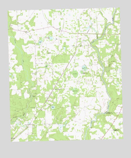
Albany NE, GA USGS Topographic Map
Click on map above to begin viewing in our Map Viewer.

This topographic map contains these locations and features:
Feature Name Type Latitude Longitude GNIS ID View Map
Abrams CreekStreamN31.6930°W84.0188°310375View Map
BeloitPopulated PlaceN31.6738°W84.0769°334179View Map
ChehawPopulated PlaceN31.7085°W84.0505°334180View Map
Coney LakeLakeN31.7191°W84.0892°312889View Map
Cypress PondLakeN31.7087°W84.0816°313253View Map
Duck Roost PondLakeN31.7229°W84.0775°313707View Map
Fish PondLakeN31.6927°W84.0410°314145View Map
Forrester BridgeBridgeN31.7321°W84.1246°343382View Map
Fox PondLakeN31.6874°W84.0516°314337View Map
Friendship CemeteryCemeteryN31.7163°W84.0032°349385View Map
Friendship ChurchChurchN31.7155°W84.0030°314402View Map
Gin BranchStreamN31.6493°W84.0271°343383View Map
Graves SpringSpringN31.6677°W84.0996°314793View Map
Hartley FarmLocaleN31.6628°W84.0708°2723916View Map
Lee County Emergency Medical Services Redbone StationBuildingN31.6529°W84.0958°2625452View Map
Lee County Fire Department Station 5 RedboneBuildingN31.6530°W84.0959°2604200View Map
Middle Cypress PondLakeN31.6893°W84.0438°318070View Map
Mill CreekStreamN31.6585°W84.0146°318219View Map
Mount Aily ChurchChurchN31.6257°W84.0252°318542View Map
Mount Hope ChurchChurchN31.7293°W84.1052°318664View Map
Mount Horeb Church (historical)ChurchN31.6996°W84.0063°343311View Map
Mount Pleasant ChurchChurchN31.7135°W84.0530°318835View Map
Negro Head BranchStreamN31.7207°W84.0255°319240View Map
Nutview (historical)Populated PlaceN31.6324°W84.1138°343398View Map
Old Mount Horeb CemeteryCemeteryN31.6991°W84.0066°320000View Map
Old Piney Grove ChurchChurchN31.7305°W84.0652°320011View Map
Philema BranchStreamN31.7346°W84.0143°356464View Map
Pleasant Green ChurchChurchN31.6416°W84.1041°320792View Map
Pye PondLakeN31.6962°W84.0829°321241View Map
Redbone School (historical)SchoolN31.6738°W84.0688°343400View Map
Saint Stephens ChurchChurchN31.6591°W84.0794°322312View Map
StocksPopulated PlaceN31.6552°W84.0905°334181View Map
Stocks (historical)Populated PlaceN31.6549°W84.0902°343405View Map
Stocks PondLakeN31.6710°W84.0518°323636View Map
Sun PondLakeN31.7218°W84.0728°323751View Map
Thundering SpringSpringN31.6885°W84.0157°343354View Map
Thundering Springs CemeteryCemeteryN31.6568°W84.0960°324147View Map
Thundering Springs ChurchChurchN31.6738°W84.0685°324148View Map
White PondLakeN31.6569°W84.0771°325186View Map
Worthy Manor Volunteer Fire Department Station 2BuildingN31.6279°W84.0040°2604583View Map
WUNV-FM (Albany)TowerN31.6724°W84.0574°352603View Map

Note: Coordinates in the location and feature list above are referenced to NAD83 datum.


Copyright (C) 2008-2024 Ryan Niemi / Sunset Dynamics ... All Rights Reserved