TopoQuest Logo
Do you find TopoQuest useful?
Help keep TopoQuest running and adding new maps/features by donating!
Bitcoin:  19c7KJd3qBynnjoSw5npx9KScwjBe4ifkT
Litecoin:  LXs6TkuXGGXo1vDsWCkWVdjQX94eUKd6ui
Home View Maps Find Maps Find Places Resources & Links


Troy, North Carolina Topographic Map

USGS Map Title: Troy, NC
USGS Map MRC: 35079C8
DRG (GeoTIFF) Download: o35079c8.tif


Neighboring USGS Topographic Map Quads:


  Badin, NC  
35080D1
 

  Lovejoy, NC  
35079D8
 

  Star, NC  
35079D7
 

  Morrow Mountain, NC  
35080C1
 

  Troy, NC  
35079C8
 

  Biscoe, NC  
35079C7
 

  Mount Gilead West, NC  
35080B1
 

  Mount Gilead East, NC  
35079B8
 

  Harrisville, NC  
35079B7


Map MRC Location:

N36°
W80°
N36°
W79°
H8 H7 H6 H5 H4 H3 H2 H1
G8 G7 G6 G5 G4 G3 G2 G1
F8 F7 F6 F5 F4 F3 F2 F1
E8 E7 E6 E5 E4 E3 E2 E1
D8 D7 D6 D5 D4 D3 D2 D1
C8 C7 C6 C5 C4 C3 C2 C1
B8 B7 B6 B5 B4 B3 B2 B1
A8 A7 A6 A5 A4 A3 A2 A1
N35°
W80°
N35°
W79°

Troy, NC USGS 1:24K Topographic Map Preview:
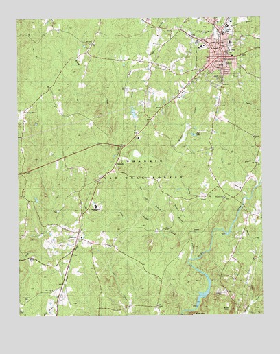
Troy, NC USGS Topographic Map
Click on map above to begin viewing in our Map Viewer.

This topographic map contains these locations and features:
Feature Name Type Latitude Longitude GNIS ID View Map
Alexander PondReservoirN35.3354°W79.9402°998818View Map
Alexander Pond DamDamN35.3335°W79.9381°998819View Map
Birds Nest AirportAirportN35.3579°W79.8892°997916View Map
Bruton CemeteryCemeteryN35.2937°W79.9792°1008285View Map
Bruton Mill PondReservoirN35.2851°W79.8931°998744View Map
Bruton Millpond DamDamN35.2851°W79.8931°998743View Map
Buck MountainSummitN35.2526°W79.8917°1003713View Map
Calvary ChurchChurchN35.2538°W79.9287°982442View Map
Cedar BranchStreamN35.2546°W79.8798°982794View Map
ChipPopulated PlaceN35.2599°W79.8934°1019669View Map
Chisolm CemeteryCemeteryN35.2854°W79.9103°1008275View Map
Clarks Grove ChurchChurchN35.3060°W79.9592°983232View Map
Duck LakeReservoirN35.3259°W79.9096°984385View Map
Eure LakeReservoirN35.2535°W79.9081°998664View Map
Eury DamDamN35.2538°W79.9089°984851View Map
First Health of the Carolinas Emergency Medical Services Base 1BuildingN35.3642°W79.8894°2720558View Map
FirstHealth Montgomery Memorial HospitalHospitalN35.3650°W79.8905°1007815View Map
Hawkins BranchStreamN35.2882°W79.9123°986527View Map
Haywood CemeteryCemeteryN35.2593°W79.8959°1003714View Map
Hill BranchStreamN35.2854°W79.9217°986791View Map
Hurley DamDamN35.2846°W79.8937°1003712View Map
Iron Hill BranchStreamN35.2854°W79.9214°1003716View Map
Liberty HillPopulated PlaceN35.3365°W79.9959°1003718View Map
Liberty Hill ChurchChurchN35.3271°W79.9978°1024082View Map
Lick BranchStreamN35.2513°W79.8825°1024083View Map
Little Rocky CreekStreamN35.2824°W79.9175°988762View Map
Long BranchStreamN35.2993°W79.8839°1024114View Map
Long Hill ChurchChurchN35.3251°W79.8784°1003839View Map
Lucky BranchStreamN35.2846°W79.8909°1013252View Map
McRae CemeteryCemeteryN35.2737°W79.9945°1003711View Map
Montgomery CountyCivilN35.3325°W79.9055°1008572View Map
Montgomery County Rescue SquadBuildingN35.3580°W79.8946°2720678View Map
Montgomery County Sheriff's OfficeBuildingN35.3583°W79.8944°2769765View Map
Mount Carmel ChurchChurchN35.3649°W79.9614°990351View Map
North Carolina Forest Service Rangers OfficeBuildingN35.3699°W79.9209°1007814View Map
Piney MountainSummitN35.2504°W79.9112°1024223View Map
Pleasant Grove ChurchChurchN35.2996°W79.8937°1003717View Map
RoberdoPopulated PlaceN35.3135°W79.9498°1022315View Map
Rocky CreekStreamN35.2738°W79.9117°1015038View Map
Ropers Grove CemeteryCemeteryN35.2568°W79.9964°993676View Map
Ropers Grove ChurchChurchN35.2610°W79.9828°993677View Map
Smith BranchStreamN35.3196°W79.9400°994930View Map
Southside CemeteryCemeteryN35.3557°W79.8934°1003721View Map
Toms BranchStreamN35.2985°W79.9078°1024355View Map
Town of TroyCivilN35.3651°W79.8916°2406760View Map
Township of TroyCivilN35.3552°W79.8930°1026965View Map
Trinity ChurchChurchN35.3610°W79.8917°1003720View Map
TroyPopulated PlaceN35.3585°W79.8945°1024364View Map
Troy City HallBuildingN35.3629°W79.8950°1003719View Map
Troy Elementary SchoolSchoolN35.3621°W79.8909°1006710View Map
Troy Fire DepartmentBuildingN35.3649°W79.8947°2639011View Map
Troy Junior High SchoolSchoolN35.3551°W79.8948°1006711View Map
Troy Lookout TowerTowerN35.3426°W79.8914°1007816View Map
Troy Police DepartmentBuildingN35.3651°W79.8940°2769787View Map
Troy Post OfficePost OfficeN35.3648°W79.8954°1024721View Map
WadevillePopulated PlaceN35.2826°W79.9698°1023090View Map
Wadeville ChurchChurchN35.2960°W79.9681°1024383View Map
Wadeville Volunteer Fire DepartmentBuildingN35.2834°W79.9690°2639086View Map
Warner CreekStreamN35.3132°W79.9234°1024391View Map
West Montgomery High SchoolSchoolN35.2963°W79.9601°1003715View Map
Yates Place CampLocaleN35.3646°W79.9887°1008295View Map

Note: Coordinates in the location and feature list above are referenced to NAD83 datum.


Copyright (C) 2008-2024 Ryan Niemi / Sunset Dynamics ... All Rights Reserved