TopoQuest Logo
Do you find TopoQuest useful?
Help keep TopoQuest running and adding new maps/features by donating!
Bitcoin:  19c7KJd3qBynnjoSw5npx9KScwjBe4ifkT
Litecoin:  LXs6TkuXGGXo1vDsWCkWVdjQX94eUKd6ui
Home View Maps Find Maps Find Places Resources & Links


Badin, North Carolina Topographic Map

USGS Map Title: Badin, NC
USGS Map MRC: 35080D1
DRG (GeoTIFF) Download: o35080d1.tif


Neighboring USGS Topographic Map Quads:


  High Rock, NC  
35080E2
 

  Handy, NC  
35080E1
 

  Eleazer, NC  
35079E8
 

  New London, NC  
35080D2
 

  Badin, NC  
35080D1
 

  Lovejoy, NC  
35079D8
 

  Albemarle, NC  
35080C2
 

  Morrow Mountain, NC  
35080C1
 

  Troy, NC  
35079C8


Map MRC Location:

N36°
W81°
N36°
W80°
H8 H7 H6 H5 H4 H3 H2 H1
G8 G7 G6 G5 G4 G3 G2 G1
F8 F7 F6 F5 F4 F3 F2 F1
E8 E7 E6 E5 E4 E3 E2 E1
D8 D7 D6 D5 D4 D3 D2 D1
C8 C7 C6 C5 C4 C3 C2 C1
B8 B7 B6 B5 B4 B3 B2 B1
A8 A7 A6 A5 A4 A3 A2 A1
N35°
W81°
N35°
W80°

Badin, NC USGS 1:24K Topographic Map Preview:
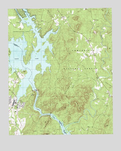
Badin, NC USGS Topographic Map
Click on map above to begin viewing in our Map Viewer.

This topographic map contains these locations and features:
Feature Name Type Latitude Longitude GNIS ID View Map
Alcoa PlantBuildingN35.4085°W80.1192°1017873View Map
BadinPopulated PlaceN35.4060°W80.1167°1027372View Map
Badin DamDamN35.4193°W80.0937°1008842View Map
Badin Fire DepartmentBuildingN35.4041°W80.1180°2638375View Map
Badin LakeReservoirN35.4575°W80.1064°1008843View Map
Badin Lake CampgroundLocaleN35.4485°W80.0787°1018127View Map
Badin Lake Group CampgroundLocaleN35.4504°W80.0714°1018125View Map
Badin Lake Volunteer First Response and Rescue - BlaineBuildingN35.4868°W80.0807°2639603View Map
Badin Lake Volunteer First Response and Rescue - PinehavenBuildingN35.4984°W80.1070°2638629View Map
Badin Police DepartmentBuildingN35.4053°W80.1146°2769897View Map
Badin Post OfficePost OfficeN35.4045°W80.1137°2774108View Map
Badin SchoolSchoolN35.4021°W80.1142°1017393View Map
Badin WaterworksLocaleN35.4143°W80.0964°1008844View Map
Barnes CreekStreamN35.4340°W80.0031°1008933View Map
Bethany Church (historical)ChurchN35.4124°W80.0028°1956767View Map
BlainePopulated PlaceN35.4913°W80.0592°1023839View Map
Cedar CreekStreamN35.3946°W80.0209°1023893View Map
Center ChurchChurchN35.4921°W80.0584°1010144View Map
Coggins MinePopulated PlaceN35.4868°W80.0203°1023914View Map
Cole MountainSummitN35.4601°W80.0042°1017790View Map
Cove Boat RampLocaleN35.4365°W80.0731°1023747View Map
Crow CreekStreamN35.4962°W80.0045°1010598View Map
Duncombe CreekStreamN35.4538°W80.0050°1010944View Map
Dutch John CreekStreamN35.3874°W80.0603°1023956View Map
Dutchmans CreekStreamN35.3863°W80.0414°1010955View Map
EldoradoPopulated PlaceN35.4671°W80.0292°1011039View Map
Eldorado Baptist ChurchChurchN35.4699°W80.0320°1957816View Map
Eldorado School (historical)SchoolN35.4690°W80.0273°1956768View Map
Fall MountainSummitN35.3868°W80.0801°1023966View Map
Falls DamDamN35.3951°W80.0753°1011170View Map
Falls MountainSummitN35.4018°W80.0587°1018126View Map
Falls ReservoirReservoirN35.3951°W80.0748°1017188View Map
Glady ForkStreamN35.4693°W80.0814°1011518View Map
Gold Mine BranchStreamN35.4129°W80.0195°1011551View Map
Graveyard IslandIslandN35.4571°W80.1234°1017784View Map
Hall BranchStreamN35.4099°W80.0195°1024019View Map
Horsepen CreekStreamN35.4804°W80.0123°1024046View Map
Lanes Chapel CemeteryCemeteryN35.4804°W80.1084°1956763View Map
Lanes Chapel Methodist ChurchChurchN35.4799°W80.1095°1012678View Map
Macedonia CemeteryCemeteryN35.4537°W80.0220°1956764View Map
Macedonia Methodist ChurchChurchN35.4535°W80.0220°1017789View Map
McLeans CreekStreamN35.4338°W80.0259°1024137View Map
Moccasin CreekStreamN35.4199°W80.0234°1013645View Map
Morrow Mountain State ParkParkN35.3932°W80.0831°1024496View Map
Mountain BranchStreamN35.4885°W80.0695°1013793View Map
Narrous DamDamN35.4201°W80.0948°1017198View Map
Narrows of the YadkinChannelN35.4190°W80.0976°1017395View Map
Palmer IslandIslandN35.4349°W80.1103°1017787View Map
Palmer MountainSummitN35.4371°W80.1059°1017788View Map
PalmervillePopulated PlaceN35.4274°W80.1176°1021786View Map
Peenington (historical)LocaleN35.4418°W80.1017°1017397View Map
Pine HavenPopulated PlaceN35.4974°W80.1048°1024497View Map
Prospect Baptist Church (historical)ChurchN35.3824°W80.0278°1956765View Map
Prospect CemeteryCemeteryN35.3826°W80.0281°1017785View Map
Rabbit MountainSummitN35.3835°W80.0081°1017786View Map
Reeves Spring BranchStreamN35.4818°W80.0637°1014818View Map
Reynolds CreekStreamN35.4851°W80.0995°1024256View Map
Russell CemeteryCemeteryN35.4999°W80.0309°1017791View Map
Shingle Trap MountainSummitN35.4043°W80.0414°1024500View Map
Spencer CreekStreamN35.4254°W80.0150°1015725View Map
Stanly County Country ClubLocaleN35.3979°W80.1109°1015788View Map
Town of BadinCivilN35.4072°W80.1183°2405196View Map
Township of EldoradoCivilN35.4593°W80.0717°1026958View Map
UwharriePopulated PlaceN35.4151°W80.0037°1016350View Map
Uwharrie Hunting CampLocaleN35.4293°W80.0217°1008218View Map
Uwharrie Methodist ChurchChurchN35.4124°W80.0028°1956766View Map
Uwharrie MountainsRangeN35.4018°W80.0589°1024376View Map
Uwharrie RiverStreamN35.3807°W80.0581°1025076View Map
Uwharrie School (historical)SchoolN35.4146°W80.0042°1956788View Map
Uwharrie Volunteer Fire DepartmentBuildingN35.4179°W80.0054°2639264View Map
Uwharrie Wildlife AreaParkN35.4265°W80.0598°1017879View Map
Watery BranchStreamN35.3935°W80.0003°1025077View Map
West Branch Moccasin CreekStreamN35.4349°W80.0306°1024397View Map
Yadkin Falls DamDamN35.3951°W80.0748°1017187View Map
Yadkin RiverStreamN35.3807°W80.0598°1024415View Map

Note: Coordinates in the location and feature list above are referenced to NAD83 datum.


Copyright (C) 2008-2024 Ryan Niemi / Sunset Dynamics ... All Rights Reserved