TopoQuest Logo
Do you find TopoQuest useful?
Help keep TopoQuest running and adding new maps/features by donating!
Bitcoin:  19c7KJd3qBynnjoSw5npx9KScwjBe4ifkT
Litecoin:  LXs6TkuXGGXo1vDsWCkWVdjQX94eUKd6ui
Home View Maps Find Maps Find Places Resources & Links


Harrisville, North Carolina Topographic Map

USGS Map Title: Harrisville, NC
USGS Map MRC: 35079B7
DRG (GeoTIFF) Download: o35079b7.tif


Neighboring USGS Topographic Map Quads:


  Troy, NC  
35079C8
 

  Biscoe, NC  
35079C7
 

  Candor, NC  
35079C6
 

  Mount Gilead East, NC  
35079B8
 

  Harrisville, NC  
35079B7
 

  Norman, NC  
35079B6
 

  Mangum, NC  
35079A8
 

  Ellerbe, NC  
35079A7
 

  Millstone Lake, NC  
35079A6


Map MRC Location:

N36°
W80°
N36°
W79°
H8 H7 H6 H5 H4 H3 H2 H1
G8 G7 G6 G5 G4 G3 G2 G1
F8 F7 F6 F5 F4 F3 F2 F1
E8 E7 E6 E5 E4 E3 E2 E1
D8 D7 D6 D5 D4 D3 D2 D1
C8 C7 C6 C5 C4 C3 C2 C1
B8 B7 B6 B5 B4 B3 B2 B1
A8 A7 A6 A5 A4 A3 A2 A1
N35°
W80°
N35°
W79°

Harrisville, NC USGS 1:24K Topographic Map Preview:
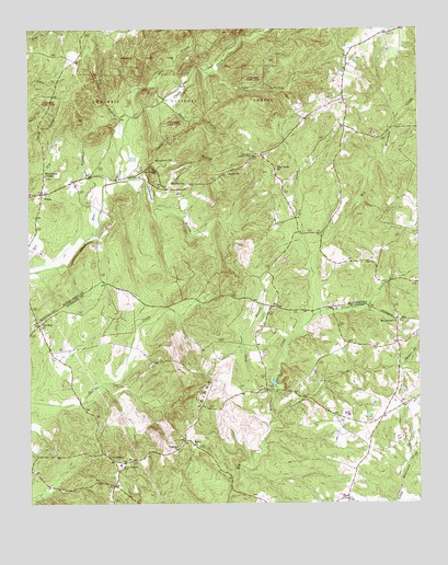
Harrisville, NC USGS Topographic Map
Click on map above to begin viewing in our Map Viewer.

This topographic map contains these locations and features:
Feature Name Type Latitude Longitude GNIS ID View Map
Beaverdam CreekStreamN35.1476°W79.7959°1009083View Map
Blackwood ChapelChurchN35.2113°W79.8695°1009462View Map
Blue BranchStreamN35.1938°W79.8575°1009489View Map
Capels MillPopulated PlaceN35.1560°W79.7962°1019525View Map
Concord ChurchChurchN35.1390°W79.8273°1010431View Map
CovingtonPopulated PlaceN35.1363°W79.8476°1010514View Map
Dry CreekStreamN35.1907°W79.7842°1010914View Map
Dry Creek ChurchChurchN35.2129°W79.7956°1010919View Map
Ex-WayPopulated PlaceN35.1721°W79.8717°1011121View Map
Gravelly BranchStreamN35.2151°W79.8339°1011666View Map
Hamer BranchStreamN35.1604°W79.7556°1011815View Map
HarrisvillePopulated PlaceN35.2090°W79.8225°1011887View Map
Harrisville Lookout TowerTowerN35.2174°W79.8031°1023644View Map
Indian BranchStreamN35.2388°W79.8162°1012328View Map
Ivy BranchStreamN35.2221°W79.8445°1012382View Map
Luther MountainSummitN35.2121°W79.8350°1021312View Map
Mount Carmel ChurchChurchN35.1732°W79.7570°1013730View Map
Mountain Creek Volunteer Fire DepartmentBuildingN35.1259°W79.7745°2638139View Map
Nells BranchStreamN35.1535°W79.7962°1013904View Map
Parsons-Howell CemeteryCemeteryN35.1343°W79.8453°1014238View Map
Pea RidgeRidgeN35.1371°W79.8384°1014282View Map
PekinPopulated PlaceN35.2068°W79.8706°1014308View Map
Pekin Volunteer Fire DepartmentBuildingN35.2048°W79.8704°2639262View Map
Polly BranchStreamN35.2368°W79.8353°1024232View Map
Sand BranchStreamN35.2315°W79.8314°1015213View Map
Sardis ChurchChurchN35.2118°W79.8112°1015255View Map
Saron ChurchChurchN35.1404°W79.8225°1015257View Map
Silver CreekStreamN35.1740°W79.7839°1015521View Map
Townsend BranchStreamN35.2099°W79.8467°1016206View Map
Woodwards BranchStreamN35.2104°W79.8414°1016822View Map

Note: Coordinates in the location and feature list above are referenced to NAD83 datum.


Copyright (C) 2008-2024 Ryan Niemi / Sunset Dynamics ... All Rights Reserved