TopoQuest Logo
Do you find TopoQuest useful?
Help keep TopoQuest running and adding new maps/features by donating!
Bitcoin:  19c7KJd3qBynnjoSw5npx9KScwjBe4ifkT
Litecoin:  LXs6TkuXGGXo1vDsWCkWVdjQX94eUKd6ui
Home View Maps Find Maps Find Places Resources & Links


Stockton, Missouri Topographic Map

USGS Map Title: Stockton, MO
USGS Map MRC: 37093F7
DRG (GeoTIFF) Download: o37093f7.tif


Neighboring USGS Topographic Map Quads:


  Filley, MO  
37093G8
 

  Caplinger Mills, MO  
37093G7
 

  Arnica, MO  
37093G6
 

  Wagoner, MO  
37093F8
 

  Stockton, MO  
37093F7
 

  Bearcreek, MO  
37093F6
 

  Cedarville, MO  
37093E8
 

  Crisp, MO  
37093E7
 

  Bona, MO  
37093E6


Map MRC Location:

N38°
W94°
N38°
W93°
H8 H7 H6 H5 H4 H3 H2 H1
G8 G7 G6 G5 G4 G3 G2 G1
F8 F7 F6 F5 F4 F3 F2 F1
E8 E7 E6 E5 E4 E3 E2 E1
D8 D7 D6 D5 D4 D3 D2 D1
C8 C7 C6 C5 C4 C3 C2 C1
B8 B7 B6 B5 B4 B3 B2 B1
A8 A7 A6 A5 A4 A3 A2 A1
N37°
W94°
N37°
W93°

Stockton, MO USGS 1:24K Topographic Map Preview:
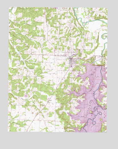
Stockton, MO USGS Topographic Map
Click on map above to begin viewing in our Map Viewer.

This topographic map contains these locations and features:
Feature Name Type Latitude Longitude GNIS ID View Map
Blue BranchStreamN37.7356°W93.8733°714395View Map
Cedar BluffCliffN37.6970°W93.7719°715563View Map
Cedar CemeteryCemeteryN37.6986°W93.7683°715575View Map
Cedar CountyCivilN37.7239°W93.8566°758474View Map
Cedar County Sheriff's OfficeBuildingN37.6976°W93.7972°2752163View Map
Center School (historical)SchoolN37.7250°W93.8435°746227View Map
City of StocktonCivilN37.6971°W93.7960°2395973View Map
Cothwell BranchStreamN37.6737°W93.7594°716338View Map
Crabtree Cove Public Use AreaParkN37.6698°W93.7533°743189View Map
Edge BranchStreamN37.6961°W93.7572°717399View Map
Excelsior ChurchChurchN37.6881°W93.8427°717703View Map
Excelsior School (historical)SchoolN37.6889°W93.8427°746228View Map
Gordon CemeteryCemeteryN37.6253°W93.7558°718611View Map
Gravel BluffCliffN37.7195°W93.7616°718735View Map
Gum Springs ChurchChurchN37.6514°W93.8288°718930View Map
Gum Springs School (historical)SchoolN37.6489°W93.8288°746229View Map
Hawker BranchStreamN37.6264°W93.7769°719228View Map
Hickman LakeReservoirN37.7495°W93.8157°763259View Map
King HillSummitN37.6445°W93.7694°720610View Map
Little Sac RiverStreamN37.6517°W93.7608°729921View Map
Miller BranchStreamN37.6423°W93.7647°722368View Map
Old Mill Public Use AreaParkN37.6992°W93.7585°743191View Map
Orleans Trail Public Use AreaParkN37.6595°W93.7833°743188View Map
Pankey CemeteryCemeteryN37.7378°W93.8277°723978View Map
Prairie Valley ChurchChurchN37.6459°W93.7833°724885View Map
Prairie Valley School (historical)SchoolN37.6498°W93.7744°746231View Map
Rose Hill School (historical)SchoolN37.7356°W93.7988°746230View Map
Rutledge BluffCliffN37.6303°W93.7794°725655View Map
StocktonPopulated PlaceN37.6989°W93.7960°729969View Map
Stockton Country ClubLocaleN37.6849°W93.7970°2678234View Map
Stockton Elementary SchoolSchoolN37.6905°W93.7959°2710759View Map
Stockton Fire DepartmentBuildingN37.6977°W93.7979°2620402View Map
Stockton High SchoolSchoolN37.6808°W93.8022°2710757View Map
Stockton Lake DamDamN37.6903°W93.7613°758403View Map
Stockton Middle SchoolSchoolN37.6911°W93.7954°2710758View Map
Stockton Municipal AirportAirportN37.6632°W93.8150°758958View Map
Stockton Police DepartmentBuildingN37.6977°W93.7978°2752500View Map
Stockton Post OfficePost OfficeN37.6983°W93.7916°2783004View Map
Stockton Public Use AreaParkN37.6820°W93.7891°743190View Map
Township of LinnCivilN37.6665°W93.8539°766453View Map

Note: Coordinates in the location and feature list above are referenced to NAD83 datum.


Copyright (C) 2008-2024 Ryan Niemi / Sunset Dynamics ... All Rights Reserved