TopoQuest Logo
Do you find TopoQuest useful?
Help keep TopoQuest running and adding new maps/features by donating!
Bitcoin:  19c7KJd3qBynnjoSw5npx9KScwjBe4ifkT
Litecoin:  LXs6TkuXGGXo1vDsWCkWVdjQX94eUKd6ui
Home View Maps Find Maps Find Places Resources & Links


Bearcreek, Missouri Topographic Map

USGS Map Title: Bearcreek, MO
USGS Map MRC: 37093F6
DRG (GeoTIFF) Download: o37093f6.tif


Neighboring USGS Topographic Map Quads:


  Caplinger Mills, MO  
37093G7
 

  Arnica, MO  
37093G6
 

  Humansville, MO  
37093G5
 

  Stockton, MO  
37093F7
 

  Bearcreek, MO  
37093F6
 

  Fair Play, MO  
37093F5
 

  Crisp, MO  
37093E7
 

  Bona, MO  
37093E6
 

  Aldrich, MO  
37093E5


Map MRC Location:

N38°
W94°
N38°
W93°
H8 H7 H6 H5 H4 H3 H2 H1
G8 G7 G6 G5 G4 G3 G2 G1
F8 F7 F6 F5 F4 F3 F2 F1
E8 E7 E6 E5 E4 E3 E2 E1
D8 D7 D6 D5 D4 D3 D2 D1
C8 C7 C6 C5 C4 C3 C2 C1
B8 B7 B6 B5 B4 B3 B2 B1
A8 A7 A6 A5 A4 A3 A2 A1
N37°
W94°
N37°
W93°

Bearcreek, MO USGS 1:24K Topographic Map Preview:
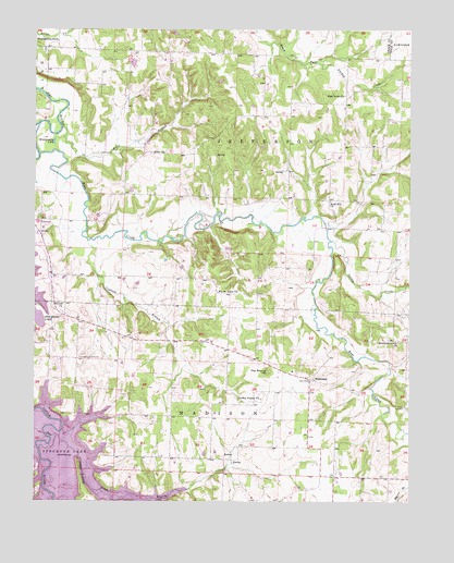
Bearcreek, MO USGS Topographic Map
Click on map above to begin viewing in our Map Viewer.

This topographic map contains these locations and features:
Feature Name Type Latitude Longitude GNIS ID View Map
Alder BranchStreamN37.7239°W93.7413°713192View Map
Alder ChurchChurchN37.7175°W93.7069°713194View Map
Alder School (historical)SchoolN37.7184°W93.7163°746232View Map
Antioch ChurchChurchN37.6775°W93.7408°713330View Map
Bear CreekStreamN37.7170°W93.7488°713795View Map
BearcreekPopulated PlaceN37.6573°W93.6583°729840View Map
Crabtree BranchStreamN37.6939°W93.7324°716445View Map
El Dorado School (historical)SchoolN37.6398°W93.7258°746234View Map
Forest Home ChurchChurchN37.6806°W93.6888°718091View Map
Friendship Community HallLocaleN37.6628°W93.7358°729892View Map
High Point ChurchChurchN37.7325°W93.6469°754182View Map
High Point School (historical)SchoolN37.7325°W93.6469°754181View Map
Indian RidgeRidgeN37.6317°W93.7347°720142View Map
Lindley Prairie CemeteryCemeteryN37.6534°W93.6744°2681412View Map
Lindley Prairie ChurchChurchN37.6523°W93.6747°721107View Map
MollieBuildingN37.7059°W93.6524°745791View Map
Montgomery LakeLakeN37.7202°W93.7439°722543View Map
Montgomery School (historical)SchoolN37.6914°W93.7485°746233View Map
Mountain Grove ChurchChurchN37.6673°W93.6291°722991View Map
Owens MillLocaleN37.7067°W93.7477°745794View Map
Price BranchStreamN37.6279°W93.7010°724920View Map
Red Hill School (historical)SchoolN37.6973°W93.6299°746235View Map
Sand Hill ChurchChurchN37.7045°W93.6516°729958View Map
Spring CreekStreamN37.6939°W93.6513°735863View Map
The MoundSummitN37.6595°W93.6724°727558View Map
Township of JeffersonCivilN37.7245°W93.6806°766452View Map
Truitt LakeReservoirN37.7411°W93.7175°763461View Map
Truitt Lake DamDamN37.7417°W93.7185°763460View Map

Note: Coordinates in the location and feature list above are referenced to NAD83 datum.


Copyright (C) 2008-2024 Ryan Niemi / Sunset Dynamics ... All Rights Reserved