TopoQuest Logo
Do you find TopoQuest useful?
Help keep TopoQuest running and adding new maps/features by donating!
Bitcoin:  19c7KJd3qBynnjoSw5npx9KScwjBe4ifkT
Litecoin:  LXs6TkuXGGXo1vDsWCkWVdjQX94eUKd6ui
Home View Maps Find Maps Find Places Resources & Links


Southerland Canyon, Texas Topographic Map

USGS Map Title: Southerland Canyon, TX
USGS Map MRC: 33100D4
DRG (GeoTIFF) Download: o33100d4.tif


Neighboring USGS Topographic Map Quads:


  Pitchfork Ranch, TX  
33100E5
 

  Pitchfork Flats, TX  
33100E4
 

  Guthrie, TX  
33100E3
 

  Pursley House, TX  
33100D5
 

  Southerland Canyon, TX  
33100D4
 

  Bob Creek, TX  
33100D3
 

  Jayton North, TX  
33100C5
 

  Seven Diamond L Canyon, TX  
33100C4
 

  Lovers Resort, TX  
33100C3


Map MRC Location:

N34°
W101°
N34°
W100°
H8 H7 H6 H5 H4 H3 H2 H1
G8 G7 G6 G5 G4 G3 G2 G1
F8 F7 F6 F5 F4 F3 F2 F1
E8 E7 E6 E5 E4 E3 E2 E1
D8 D7 D6 D5 D4 D3 D2 D1
C8 C7 C6 C5 C4 C3 C2 C1
B8 B7 B6 B5 B4 B3 B2 B1
A8 A7 A6 A5 A4 A3 A2 A1
N33°
W101°
N33°
W100°

Southerland Canyon, TX USGS 1:24K Topographic Map Preview:
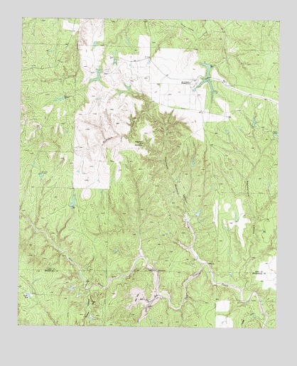
Southerland Canyon, TX USGS Topographic Map
Click on map above to begin viewing in our Map Viewer.

This topographic map contains these locations and features:
Feature Name Type Latitude Longitude GNIS ID View Map
Bar S RanchLocaleN33.4745°W100.4184°1351495View Map
Bar S Ranch Airport (historical)AirportN33.4668°W100.4173°1386778View Map
Bar S Ranch LakeReservoirN33.4820°W100.4111°1858899View Map
Bar S Ranch Lake DamDamN33.4818°W100.4087°1858898View Map
Bar S Ranch Upper LakeReservoirN33.4768°W100.4104°1862916View Map
Bar S Ranch Upper Lake DamDamN33.4768°W100.4104°1862915View Map
Bitter GulchValleyN33.3809°W100.3812°1352260View Map
Dove CreekStreamN33.3879°W100.4318°1373439View Map
Dove Creek SpringSpringN33.3909°W100.4596°1998506View Map
Hackberry WindmillLocaleN33.4368°W100.4901°1358606View Map
Haystack Brine SpringsSpringN33.4084°W100.4254°1998507View Map
Haystack CanyonValleyN33.4074°W100.4171°1358950View Map
Haystack CreekStreamN33.4009°W100.4107°1358951View Map
Haystack MountainSummitN33.4495°W100.4423°1358953View Map
Panther CanyonValleyN33.3898°W100.4660°1364770View Map
Salt CreekStreamN33.3848°W100.4365°1367406View Map
Salt FlatFlatN33.3868°W100.4429°1367426View Map
Salt Flat Brine SpringSpringN33.3918°W100.4421°1998284View Map
Salt Flat CreekStreamN33.3879°W100.4321°1367428View Map
South TankReservoirN33.3864°W100.4945°1368784View Map
Southerland CanyonValleyN33.3912°W100.3913°1368838View Map
Texas No Name Number 21 DamDamN33.4218°W100.4837°1864463View Map

Note: Coordinates in the location and feature list above are referenced to NAD83 datum.


Copyright (C) 2008-2024 Ryan Niemi / Sunset Dynamics ... All Rights Reserved