TopoQuest Logo
Do you find TopoQuest useful?
Help keep TopoQuest running and adding new maps/features by donating!
Bitcoin:  19c7KJd3qBynnjoSw5npx9KScwjBe4ifkT
Litecoin:  LXs6TkuXGGXo1vDsWCkWVdjQX94eUKd6ui
Home View Maps Find Maps Find Places Resources & Links


Pitchfork Ranch, Texas Topographic Map

USGS Map Title: Pitchfork Ranch, TX
USGS Map MRC: 33100E5
DRG (GeoTIFF) Download: o33100e5.tif


Neighboring USGS Topographic Map Quads:


  East Afton, TX  
33100F6
 

  East Afton NE, TX  
33100F5
 

  Guthrie NW, TX  
33100F4
 

  Croton Camp, TX  
33100E6
 

  Pitchfork Ranch, TX  
33100E5
 

  Pitchfork Flats, TX  
33100E4
 

  Gilpin, TX  
33100D6
 

  Pursley House, TX  
33100D5
 

  Southerland Canyon, TX  
33100D4


Map MRC Location:

N34°
W101°
N34°
W100°
H8 H7 H6 H5 H4 H3 H2 H1
G8 G7 G6 G5 G4 G3 G2 G1
F8 F7 F6 F5 F4 F3 F2 F1
E8 E7 E6 E5 E4 E3 E2 E1
D8 D7 D6 D5 D4 D3 D2 D1
C8 C7 C6 C5 C4 C3 C2 C1
B8 B7 B6 B5 B4 B3 B2 B1
A8 A7 A6 A5 A4 A3 A2 A1
N33°
W101°
N33°
W100°

Pitchfork Ranch, TX USGS 1:24K Topographic Map Preview:
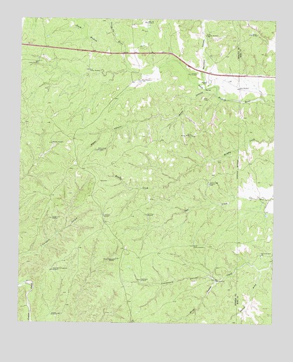
Pitchfork Ranch, TX USGS Topographic Map
Click on map above to begin viewing in our Map Viewer.

This topographic map contains these locations and features:
Feature Name Type Latitude Longitude GNIS ID View Map
Corner WindmillPopulated PlaceN33.6190°W100.5121°1379593View Map
Croton WindmillLocaleN33.5179°W100.5282°1355422View Map
Davidson CanyonValleyN33.6011°W100.5355°1355676View Map
Devils Playground WindmillLocaleN33.5259°W100.5776°1355975View Map
Double Tubs WindmillLocaleN33.5426°W100.6090°1356195View Map
East Presley WindmillLocaleN33.6040°W100.5912°1356682View Map
Farm WindmillLocaleN33.5998°W100.5651°1357242View Map
Flakemoore CanyonValleyN33.5175°W100.5280°1357414View Map
Flakemoore WindmillLocaleN33.5176°W100.5646°1357415View Map
Fortyone WindmillLocaleN33.5437°W100.5837°1357609View Map
Geneva ForkStreamN33.6195°W100.5798°1357941View Map
Goat WindmillLocaleN33.5965°W100.5176°1358099View Map
Hanna DrawValleyN33.5221°W100.5065°1358735View Map
Hanna WindmillLocaleN33.5281°W100.5057°1358738View Map
Humble WindmillLocaleN33.5034°W100.6060°1359821View Map
James Hodge WindmillLocaleN33.5576°W100.5318°1360143View Map
Matador WindmillLocaleN33.5734°W100.6096°1362276View Map
North Brushy WindmillLocaleN33.5776°W100.5407°1364005View Map
Orchard WindmillLocaleN33.6026°W100.5412°1364581View Map
Pitchfork RanchLocaleN33.5990°W100.5329°1365356View Map
Salt Creek WindmillLocaleN33.5445°W100.5621°1367417View Map
South Brushy WindmillLocaleN33.5318°W100.5393°1368646View Map
South Davidson WindmillLocaleN33.6181°W100.5340°1368667View Map
Water CanyonValleyN33.5936°W100.5294°1370899View Map
Water Canyon WindmillLocaleN33.5709°W100.5868°1370903View Map
West Devils Playground WindmillLocaleN33.5212°W100.6085°1371111View Map
West Presley WindmillLocaleN33.6070°W100.6165°1371193View Map
West Vat WindmillLocaleN33.6234°W100.5623°1371252View Map

Note: Coordinates in the location and feature list above are referenced to NAD83 datum.


Copyright (C) 2008-2024 Ryan Niemi / Sunset Dynamics ... All Rights Reserved