TopoQuest Logo
Do you find TopoQuest useful?
Help keep TopoQuest running and adding new maps/features by donating!
Bitcoin:  19c7KJd3qBynnjoSw5npx9KScwjBe4ifkT
Litecoin:  LXs6TkuXGGXo1vDsWCkWVdjQX94eUKd6ui
Home View Maps Find Maps Find Places Resources & Links


Shohola, Pennsylvania Topographic Map

USGS Map Title: Shohola, PA
USGS Map MRC: 41074D8
DRG (GeoTIFF) Download: o41074d8.tif


Neighboring USGS Topographic Map Quads:


  Narrowsburg, NY  
41075E1
 

  Eldred, NY  
41074E8
 

  Highland Lake, NY  
41074E7
 

  Rowland, PA  
41075D1
 

  Shohola, PA  
41074D8
 

  Pond Eddy, NY  
41074D7
 

  Pecks Pond, PA  
41075C1
 

  Edgemere, PA  
41074C8
 

  Milford, PA  
41074C7


Map MRC Location:

N42°
W75°
N42°
W74°
H8 H7 H6 H5 H4 H3 H2 H1
G8 G7 G6 G5 G4 G3 G2 G1
F8 F7 F6 F5 F4 F3 F2 F1
E8 E7 E6 E5 E4 E3 E2 E1
D8 D7 D6 D5 D4 D3 D2 D1
C8 C7 C6 C5 C4 C3 C2 C1
B8 B7 B6 B5 B4 B3 B2 B1
A8 A7 A6 A5 A4 A3 A2 A1
N41°
W75°
N41°
W74°

Shohola, PA USGS 1:24K Topographic Map Preview:
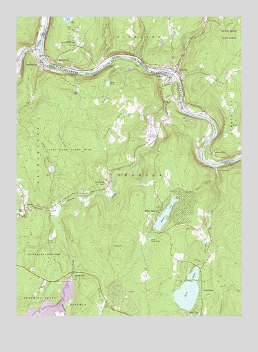
Shohola, PA USGS Topographic Map
Click on map above to begin viewing in our Map Viewer.

This topographic map contains these locations and features:
Feature Name Type Latitude Longitude GNIS ID View Map
Bald HillSummitN41.4043°W74.9404°1198350View Map
Balliard CreekStreamN41.4193°W74.9996°1199829View Map
BarryvillePopulated PlaceN41.4776°W74.9110°943090View Map
Beaver BrookStreamN41.4820°W74.9479°943359View Map
Cadoo DamDamN41.3848°W74.9529°1208843View Map
German HillSummitN41.4505°W74.9512°1198794View Map
German Hill CemeteryCemeteryN41.4592°W74.9383°1198795View Map
Grassy BrookStreamN41.4220°W74.9735°1198819View Map
GreeleyPopulated PlaceN41.4212°W74.9952°1198830View Map
Greeley Post OfficePost OfficeN41.4223°W74.9959°2780032View Map
Halfway BrookStreamN41.4759°W74.9124°952033View Map
Handsome EddyPopulated PlaceN41.4429°W74.8907°952153View Map
Hickok BrookStreamN41.4981°W74.8941°952683View Map
Hillside ChurchChurchN41.4548°W74.8768°952857View Map
Hirsch DamDamN41.4734°W74.9479°1208824View Map
Hirsh PondLakeN41.4720°W74.9489°1198891View Map
LackawaxenPopulated PlaceN41.4820°W74.9860°1198986View Map
Lackawaxen Post OfficePost OfficeN41.4813°W74.9857°2780031View Map
Lackawaxen RiverStreamN41.4876°W74.9868°1198987View Map
Lackawaxen Township Volunteer Ambulance Service Greeley StationBuildingN41.4201°W74.9948°2722135View Map
Lackawaxen Township Volunteer Fire DepartmentBuildingN41.4852°W74.9911°2653176View Map
Laurel SwampSwampN41.4460°W74.9724°1199009View Map
Little Walker LakeLakeN41.4073°W74.9250°1199068View Map
McCain School (historical)SchoolN41.4262°W74.9688°1197912View Map
Minisink Battlefield County ParkParkN41.4875°W74.9703°2100135View Map
Minisink Battlefield MemorialLocaleN41.4884°W74.9702°974756View Map
Minisink FordPopulated PlaceN41.4826°W74.9768°972805View Map
Montoza CemeteryCemeteryN41.4822°W74.9124°957563View Map
Panther CreekStreamN41.4806°W74.9304°1199271View Map
Parkers GlenPopulated PlaceN41.4362°W74.8860°1204361View Map
Phillips DamDamN41.4598°W74.9654°1208853View Map
Rattlesnake CreekStreamN41.3801°W74.9752°1199355View Map
Roebling BridgeBridgeN41.4825°W74.9844°2100136View Map
Roth DamDamN41.4284°W74.9938°1208844View Map
Saint Anns ChurchChurchN41.4731°W74.9168°1199435View Map
Saint Jacobi ChurchChurchN41.4718°W74.9163°1199440View Map
Saint Marks ChurchChurchN41.4840°W74.9868°1199450View Map
Sap BrookStreamN41.4073°W74.8927°1199485View Map
ShoholaPopulated PlaceN41.4751°W74.9152°1199528View Map
Shohola CreekStreamN41.4734°W74.9096°1199529View Map
Shohola Elementary SchoolSchoolN41.3793°W74.8938°1214528View Map
Shohola FallsPopulated PlaceN41.3909°W74.9660°1199530View Map
Shohola FallsFallsN41.3912°W74.9693°1201458View Map
Shohola Falls Trails EndLocaleN41.3820°W74.9391°1212892View Map
Shohola Marsh DamDamN41.3901°W74.9696°1214117View Map
Shohola Marsh ReservoirReservoirN41.3761°W74.9888°1214116View Map
Shohola Post OfficePost OfficeN41.4734°W74.9168°2780000View Map
Shohola SchoolSchoolN41.4643°W74.9149°1199531View Map
Shohola Township Police DepartmentBuildingN41.4641°W74.9156°2777215View Map
Shohola Volunteer Fire and Rescue Company 1 Main StationBuildingN41.4500°W74.9256°2653095View Map
Shohola Volunteer Fire and Rescue Company 41BuildingN41.4135°W74.9147°2652596View Map
State Game Lands Number 116ParkN41.4431°W74.9704°1199593View Map
Township of ShoholaCivilN41.4191°W74.9080°1216965View Map
Twin LakesLakeN41.3836°W74.9051°1199709View Map
Twin LakesPopulated PlaceN41.3895°W74.8971°1199710View Map
Twin Lakes CreekStreamN41.4379°W74.8882°1199711View Map
Twin Lakes DamDamN41.3901°W74.9063°1214115View Map
Twin Lakes Post Office (historical)Post OfficeN41.3895°W74.8971°2027093View Map
Verga PondLakeN41.4690°W74.9654°1199728View Map
Walker LakeReservoirN41.4170°W74.9172°1200125View Map
Walker LakePopulated PlaceN41.4190°W74.9185°1199731View Map
Walker Lake CreekStreamN41.4312°W74.8885°1199732View Map
Walker Lake DamDamN41.3751°W74.9146°1214114View Map
Walker Lake Post Office (historical)Post OfficeN41.4190°W74.9185°2027092View Map
White DamDamN41.3826°W74.8854°1208823View Map
Winkler DamDamN41.4312°W74.9960°1208854View Map
Woodtown CemeteryCemeteryN41.4115°W74.9001°1199815View Map
Woodtown School (historical)SchoolN41.4137°W74.9096°1197911View Map
Zane Grey MuseumBuildingN41.4853°W74.9881°2104448View Map

Note: Coordinates in the location and feature list above are referenced to NAD83 datum.


Copyright (C) 2008-2024 Ryan Niemi / Sunset Dynamics ... All Rights Reserved