TopoQuest Logo
Do you find TopoQuest useful?
Help keep TopoQuest running and adding new maps/features by donating!
Bitcoin:  19c7KJd3qBynnjoSw5npx9KScwjBe4ifkT
Litecoin:  LXs6TkuXGGXo1vDsWCkWVdjQX94eUKd6ui
Home View Maps Find Maps Find Places Resources & Links


Pond Eddy, New York Topographic Map

USGS Map Title: Pond Eddy, NY
USGS Map MRC: 41074D7
DRG (GeoTIFF) Download: o41074d7.tif


Neighboring USGS Topographic Map Quads:


  Eldred, NY  
41074E8
 

  Highland Lake, NY  
41074E7
 

  Hartwood, NY  
41074E6
 

  Shohola, PA  
41074D8
 

  Pond Eddy, NY  
41074D7
 

  Port Jervis North, NY  
41074D6
 

  Edgemere, PA  
41074C8
 

  Milford, PA  
41074C7
 

  Port Jervis South, NY  
41074C6


Map MRC Location:

N42°
W75°
N42°
W74°
H8 H7 H6 H5 H4 H3 H2 H1
G8 G7 G6 G5 G4 G3 G2 G1
F8 F7 F6 F5 F4 F3 F2 F1
E8 E7 E6 E5 E4 E3 E2 E1
D8 D7 D6 D5 D4 D3 D2 D1
C8 C7 C6 C5 C4 C3 C2 C1
B8 B7 B6 B5 B4 B3 B2 B1
A8 A7 A6 A5 A4 A3 A2 A1
N41°
W75°
N41°
W74°

Pond Eddy, NY USGS 1:24K Topographic Map Preview:
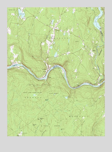
Pond Eddy, NY USGS Topographic Map
Click on map above to begin viewing in our Map Viewer.

This topographic map contains these locations and features:
Feature Name Type Latitude Longitude GNIS ID View Map
Buckhorn Natural AreaAreaN41.4095°W74.8149°1212898View Map
Buckhorn RidgeRidgeN41.3929°W74.8329°1198495View Map
Buckhorn Ridge Fire TowerTowerN41.3926°W74.8329°1212899View Map
Bush KillStreamN41.4643°W74.7504°945313View Map
Bushkill SwampSwampN41.4095°W74.8242°1198505View Map
Fish Cabin CreekStreamN41.4409°W74.8035°950121View Map
George Ross MacKenzie Elementary SchoolSchoolN41.4823°W74.8175°2597980View Map
Glen SpeyPopulated PlaceN41.4787°W74.8135°951194View Map
Homestead SchoolSchoolN41.4647°W74.8300°2597978View Map
Knights EddyPopulated PlaceN41.4251°W74.7854°954780View Map
Lochada LakeLakeN41.4941°W74.8566°955774View Map
Lost Cabin TrailTrailN41.3879°W74.8107°1205702View Map
Lower Mongaup CemeteryCemeteryN41.4281°W74.7566°2371789View Map
Lumberland Volunteer Fire Department Station 1BuildingN41.4791°W74.8087°2718602View Map
Lumberland Volunteer Fire Department Station 2BuildingN41.4417°W74.8221°2735409View Map
Mill BrookStreamN41.4387°W74.8213°957200View Map
MongaupPopulated PlaceN41.4248°W74.7621°972809View Map
Mongaup RiverStreamN41.4254°W74.7549°957518View Map
Mongaup Station (historical)LocaleN41.4245°W74.7746°1197852View Map
Pine Knot RidgeRidgeN41.3868°W74.8427°1199307View Map
Pond EddyPopulated PlaceN41.4312°W74.8229°1199326View Map
Pond EddyPopulated PlaceN41.4404°W74.8232°960889View Map
Pond Eddy CreekStreamN41.4306°W74.8257°1199327View Map
Rio ReservoirReservoirN41.4819°W74.7580°962537View Map
RosasPopulated PlaceN41.4415°W74.8091°1199412View Map
Sacred Heart ChurchChurchN41.4376°W74.8241°963187View Map
Stairway Hunt Club DamDamN41.4134°W74.7963°1195557View Map
Stairway LakeReservoirN41.4126°W74.7987°1195558View Map
State Game Lands Number 209ParkN41.4168°W74.8329°1208074View Map
Tink HillSummitN41.4662°W74.7871°967543View Map
Town of LumberlandCivilN41.4937°W74.8116°979172View Map
Township of WestfallCivilN41.3825°W74.7693°1216966View Map
Upper MongaupPopulated PlaceN41.4576°W74.7649°968284View Map
Van Tuyl CemeteryCemeteryN41.4457°W74.8678°952839View Map
Wallowing HoleBayN41.3818°W74.8074°1199737View Map

Note: Coordinates in the location and feature list above are referenced to NAD83 datum.


Copyright (C) 2008-2024 Ryan Niemi / Sunset Dynamics ... All Rights Reserved