TopoQuest Logo
Do you find TopoQuest useful?
Help keep TopoQuest running and adding new maps/features by donating!
Bitcoin:  19c7KJd3qBynnjoSw5npx9KScwjBe4ifkT
Litecoin:  LXs6TkuXGGXo1vDsWCkWVdjQX94eUKd6ui
Home View Maps Find Maps Find Places Resources & Links


Milford, Pennsylvania Topographic Map

USGS Map Title: Milford, PA
USGS Map MRC: 41074C7
DRG (GeoTIFF) Download: o41074c7.tif


Neighboring USGS Topographic Map Quads:


  Shohola, PA  
41074D8
 

  Pond Eddy, NY  
41074D7
 

  Port Jervis North, NY  
41074D6
 

  Edgemere, PA  
41074C8
 

  Milford, PA  
41074C7
 

  Port Jervis South, NY  
41074C6
 

  Lake Maskenozha, PA  
41074B8
 

  Culvers Gap, NJ  
41074B7
 

  Branchville, NJ  
41074B6


Map MRC Location:

N42°
W75°
N42°
W74°
H8 H7 H6 H5 H4 H3 H2 H1
G8 G7 G6 G5 G4 G3 G2 G1
F8 F7 F6 F5 F4 F3 F2 F1
E8 E7 E6 E5 E4 E3 E2 E1
D8 D7 D6 D5 D4 D3 D2 D1
C8 C7 C6 C5 C4 C3 C2 C1
B8 B7 B6 B5 B4 B3 B2 B1
A8 A7 A6 A5 A4 A3 A2 A1
N41°
W75°
N41°
W74°

Milford, PA USGS 1:24K Topographic Map Preview:
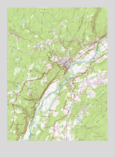
Milford, PA USGS Topographic Map
Click on map above to begin viewing in our Map Viewer.

This topographic map contains these locations and features:
Feature Name Type Latitude Longitude GNIS ID View Map
AbertownPopulated PlaceN41.2509°W74.7846°874235View Map
Beaver LakeReservoirN41.3013°W74.8602°1169014View Map
Beaver Lake Lodge DamDamN41.3001°W74.8613°1195457View Map
BeerskillStreamN41.2559°W74.7991°874639View Map
Borough of MilfordCivilN41.3238°W74.8011°1215535View Map
Cliff Park Inn Golf CourseLocaleN41.3076°W74.8263°1206563View Map
ConashaughPopulated PlaceN41.2712°W74.8491°1203316View Map
Conashaugh CreekStreamN41.2690°W74.8429°1172277View Map
Craft BrookStreamN41.3520°W74.8504°1172590View Map
Crawford BranchStreamN41.3248°W74.7771°1172646View Map
Cummins CreekStreamN41.3440°W74.7579°1172835View Map
Decker CemeteryCemeteryN41.3281°W74.7598°875839View Map
Deep BrookStreamN41.3343°W74.7977°1173055View Map
Dimmick Meadow BrookStreamN41.3465°W74.8366°1173281View Map
Dry BrookStreamN41.2515°W74.8529°1173496View Map
Fairview LakeReservoirN41.2975°W74.8618°1202906View Map
Foster HillSummitN41.3318°W74.8054°1175039View Map
Four CornersPopulated PlaceN41.2882°W74.7627°876437View Map
Franklin SchoolSchoolN41.3179°W74.8410°1197850View Map
Gregory DamDamN41.3137°W74.8318°1208857View Map
HainesvillePopulated PlaceN41.2520°W74.8029°876880View Map
Hainesville CemeteryCemeteryN41.2559°W74.7941°876881View Map
Hainesville Fish and Wildlife Management AreaParkN41.2668°W74.7829°883040View Map
Holiday LakeLakeN41.3065°W74.7596°883160View Map
Indian PointPopulated PlaceN41.2856°W74.8343°1177769View Map
Laurel BrookStreamN41.3418°W74.8046°1178924View Map
Lily PondReservoirN41.3625°W74.8546°1179344View Map
Lily Pond DamDamN41.3606°W74.8554°1208849View Map
Long Meadow SwampSwampN41.2951°W74.7593°877917View Map
McCartys CornerPopulated PlaceN41.2918°W74.8629°1180615View Map
Metz DamDamN41.3170°W74.7993°1208858View Map
MilfordPopulated PlaceN41.3223°W74.8024°1181106View Map
Milford Borough Police DepartmentBuildingN41.3245°W74.8024°2777109View Map
Milford CemeteryCemeteryN41.3138°W74.8047°1181107View Map
Milford Fire Department and AmbulanceBuildingN41.3244°W74.8021°2652674View Map
Milford Post OfficePost OfficeN41.3233°W74.8055°2779626View Map
Milford ReservoirReservoirN41.3314°W74.8193°1181108View Map
MillvillePopulated PlaceN41.3131°W74.7799°878391View Map
Minisink ChurchChurchN41.3062°W74.7929°878408View Map
Minisink IslandIslandN41.2884°W74.8229°878409View Map
MontaguePopulated PlaceN41.3031°W74.7935°878445View Map
Montague Volunteer Fire DepartmentBuildingN41.3127°W74.7614°2614283View Map
Namanock IslandIslandN41.2631°W74.8416°878682View Map
Pike County Advanced Life SupportBuildingN41.3356°W74.8338°2722136View Map
Pike County Sheriff's OfficeBuildingN41.3247°W74.8005°2776916View Map
Pinchot BrookStreamN41.3518°W74.8504°1183753View Map
Pinchot FallsFallsN41.3279°W74.8227°1193123View Map
Pine HillSummitN41.3481°W74.7724°1183829View Map
Pond Lily DamDamN41.3601°W74.8546°1195497View Map
Pow Wow HillSummitN41.2809°W74.8460°1184356View Map
Quicks IslandIslandN41.3259°W74.7674°879573View Map
Quicktown SchoolSchoolN41.3423°W74.7632°1197848View Map
Quinns CornerPopulated PlaceN41.3165°W74.8460°1204456View Map
Raymondskill CreekStreamN41.2856°W74.8307°1198109View Map
Raymondskill FallsFallsN41.2887°W74.8416°1193172View Map
Red RidgeRidgeN41.3737°W74.8607°1184776View Map
Richartz DamDamN41.3059°W74.8529°1208826View Map
Rowe DamDamN41.3262°W74.8124°1208820View Map
Saint Thomas ChurchChurchN41.2512°W74.8027°880216View Map
Sandyston Township Fire DepartmentBuildingN41.2515°W74.8041°2613731View Map
Sandystone ChurchChurchN41.2504°W74.8038°880264View Map
Savantine CreekStreamN41.3501°W74.8635°1199487View Map
Sawkill CreekStreamN41.3176°W74.7968°1198120View Map
ShaytownPopulated PlaceN41.2584°W74.7913°880526View Map
Shimers BrookStreamN41.3120°W74.7907°880557View Map
Silver SpringPopulated PlaceN41.2995°W74.8488°1187692View Map
Silver Springs LakeReservoirN41.3013°W74.8475°1195458View Map
Sloat BrookStreamN41.3231°W74.8154°1187829View Map
Spring House DamDamN41.3004°W74.8471°1208829View Map
Springhouse DamDamN41.3018°W74.8479°1195459View Map
Swale BrookStreamN41.3023°W74.8588°1189121View Map
The CliffCliffN41.3031°W74.8224°1189394View Map
The KnobSummitN41.3181°W74.8060°1189415View Map
Township of MilfordCivilN41.3545°W74.8354°1216962View Map
Travis CemeteryCemeteryN41.3334°W74.8677°1189731View Map
Union SchoolSchoolN41.3018°W74.8535°1197851View Map
Upper Morningstar DamDamN41.3098°W74.8302°1208827View Map
Vandermark CreekStreamN41.3218°W74.7941°1190355View Map
Vantine BrookStreamN41.3234°W74.8110°1190363View Map
White BrookStreamN41.3045°W74.8027°881777View Map
Yale Forest School (historical)SchoolN41.3295°W74.8352°1197849View Map

Note: Coordinates in the location and feature list above are referenced to NAD83 datum.


Copyright (C) 2008-2024 Ryan Niemi / Sunset Dynamics ... All Rights Reserved