TopoQuest Logo
Do you find TopoQuest useful?
Help keep TopoQuest running and adding new maps/features by donating!
Bitcoin:  19c7KJd3qBynnjoSw5npx9KScwjBe4ifkT
Litecoin:  LXs6TkuXGGXo1vDsWCkWVdjQX94eUKd6ui
Home View Maps Find Maps Find Places Resources & Links


Saint Michael, Minnesota Topographic Map

USGS Map Title: Saint Michael, MN
USGS Map MRC: 45093B6
DRG (GeoTIFF) Download: o45093b6.tif


Neighboring USGS Topographic Map Quads:


  Monticello, MN  
45093C7
 

  Big Lake, MN  
45093C6
 

  Elk River, MN  
45093C5
 

  Buffalo East, MN  
45093B7
 

  Saint Michael, MN  
45093B6
 

  Rogers, MN  
45093B5
 

  Delano, MN  
45093A7
 

  Rockford, MN  
45093A6
 

  Hamel, MN  
45093A5


Map MRC Location:

N46°
W94°
N46°
W93°
H8 H7 H6 H5 H4 H3 H2 H1
G8 G7 G6 G5 G4 G3 G2 G1
F8 F7 F6 F5 F4 F3 F2 F1
E8 E7 E6 E5 E4 E3 E2 E1
D8 D7 D6 D5 D4 D3 D2 D1
C8 C7 C6 C5 C4 C3 C2 C1
B8 B7 B6 B5 B4 B3 B2 B1
A8 A7 A6 A5 A4 A3 A2 A1
N45°
W94°
N45°
W93°

Saint Michael, MN USGS 1:24K Topographic Map Preview:
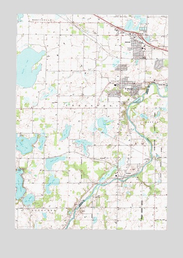
Saint Michael, MN USGS Topographic Map
Click on map above to begin viewing in our Map Viewer.

This topographic map contains these locations and features:
Feature Name Type Latitude Longitude GNIS ID View Map
AlbertvilleLocaleN45.2344°W93.6478°2067515View Map
AlbertvillePopulated PlaceN45.2377°W93.6544°639253View Map
Albertville City HallBuildingN45.2361°W93.6542°2067511View Map
Albertville Elementary SchoolSchoolN45.2272°W93.6542°2067509View Map
Albertville Fire DepartmentBuildingN45.2351°W93.6580°2666546View Map
Albertville Post OfficePost OfficeN45.2373°W93.6535°2067527View Map
Albertville Primary SchoolSchoolN45.2299°W93.6529°2432994View Map
Alleluia Lutheran ChurchChurchN45.2100°W93.6567°2067498View Map
Beebe LakeLakeN45.1743°W93.7437°639865View Map
Bernings Mill Dam (historical)DamN45.1666°W93.6669°1776427View Map
Cedar Creek Golf CourseLocaleN45.2394°W93.6792°2067507View Map
City of AlbertvilleCivilN45.2365°W93.6617°2393904View Map
City of HanoverCivilN45.1581°W93.6629°2394288View Map
City of Saint MichaelCivilN45.2014°W93.6919°2396509View Map
Colonial MallLocaleN45.2100°W93.6647°2067505View Map
Crow River Reservoir (historical)ReservoirN45.1666°W93.6669°1776428View Map
Elliott SchoolSchoolN45.1947°W93.7372°643288View Map
Fairview Northland ClinicHospitalN45.2100°W93.6647°2067504View Map
Fieldstone Elementary SchoolSchoolN45.2304°W93.6870°2432878View Map
Gonz LakeLakeN45.1855°W93.6780°644209View Map
Good News Alliance ChurchChurchN45.2100°W93.6647°2067503View Map
HanoverPopulated PlaceN45.1558°W93.6664°644632View Map
Hanover City HallBuildingN45.1592°W93.6650°2067474View Map
Hanover Elementary SchoolSchoolN45.1566°W93.6674°2067475View Map
Hanover Fire DepartmentBuildingN45.1578°W93.6654°2666491View Map
Hanover Post OfficePost OfficeN45.1558°W93.6661°2067350View Map
Hunters LakeLakeN45.2450°W93.6491°648357View Map
Interchange 201CrossingN45.2411°W93.6639°2067516View Map
Interchange 202CrossingN45.2378°W93.6486°2067517View Map
Johnson AirportAirportN45.1505°W93.7400°660382View Map
Knights Academy - Alternative High SchoolSchoolN45.2105°W93.6660°2432880View Map
Lake CharlotteLakeN45.1508°W93.7473°641122View Map
Lake MarthaLakeN45.1420°W93.7389°647570View Map
Lake WilhelmLakeN45.1742°W93.6941°654153View Map
Life in Christ Lutheran ChurchChurchN45.2417°W93.6542°2067508View Map
Mud LakeLakeN45.1752°W93.7288°648234View Map
North Rockford SchoolSchoolN45.1291°W93.7483°648681View Map
North Twin LakeLakeN45.1952°W93.6280°1815382View Map
Outlets at AlbertvilleLocaleN45.2444°W93.6578°2067512View Map
Prairie LakeLakeN45.1911°W93.6447°1815384View Map
Reich CemeteryCemeteryN45.1308°W93.6667°2101119View Map
Riverside County ParkParkN45.1661°W93.6397°1815381View Map
Saint Albert CemeteryCemeteryN45.2372°W93.6430°650487View Map
Saint Albert's ChurchChurchN45.2319°W93.6478°2067513View Map
Saint MichaelPopulated PlaceN45.2100°W93.6650°650903View Map
Saint Michael - Albertville High SchoolSchoolN45.2234°W93.6594°2433235View Map
Saint Michael Albertville Senior High SchoolSchoolN45.2244°W93.6528°2067514View Map
Saint Michael Catholic SchoolSchoolN45.2106°W93.6641°2432932View Map
Saint Michael CemeteryCemeteryN45.2116°W93.6652°1815385View Map
Saint Michael CemeteryCemeteryN45.1986°W93.6644°650909View Map
Saint Michael City HallBuildingN45.2097°W93.6653°2067502View Map
Saint Michael Elementary SchoolSchoolN45.2092°W93.6686°2067500View Map
Saint Michael Fire Department Central Fire StationBuildingN45.2061°W93.6644°2067501View Map
Saint Michael Fire Department Frankfort StationBuildingN45.2108°W93.6393°2666641View Map
Saint Michael Post OfficePost OfficeN45.2100°W93.6567°2067499View Map
Salem Lutheran ChurchChurchN45.1292°W93.6650°2104112View Map
Salem Lutheran Church CemeteryCemeteryN45.1292°W93.6667°2101120View Map
Salem Lutheran SchoolSchoolN45.1290°W93.6671°2432866View Map
Salem SchoolSchoolN45.1291°W93.6652°651115View Map
School LakeLakeN45.2436°W93.6574°651314View Map
School LakeSwampN45.2028°W93.7234°651322View Map
Steele LakeLakeN45.1641°W93.7189°652597View Map
Tessmer Dairy FarmLocaleN45.1378°W93.6339°2635904View Map
Township of Frankfort (historical)CivilN45.1991°W93.6900°664216View Map
Twin LakeLakeN45.1922°W93.6336°1815383View Map
Uhl LakeLakeN45.1811°W93.7090°653484View Map
Wagner LakeLakeN45.1517°W93.7199°653715View Map
Welter Brothers DamDamN45.2000°W93.6469°1776431View Map
Zion ChurchChurchN45.1672°W93.6561°654476View Map

Note: Coordinates in the location and feature list above are referenced to NAD83 datum.


Copyright (C) 2008-2024 Ryan Niemi / Sunset Dynamics ... All Rights Reserved