TopoQuest Logo
Do you find TopoQuest useful?
Help keep TopoQuest running and adding new maps/features by donating!
Bitcoin:  19c7KJd3qBynnjoSw5npx9KScwjBe4ifkT
Litecoin:  LXs6TkuXGGXo1vDsWCkWVdjQX94eUKd6ui
Home View Maps Find Maps Find Places Resources & Links


Prestonsburg, Kentucky Topographic Map

USGS Map Title: Prestonsburg, KY
USGS Map MRC: 37082F7
DRG (GeoTIFF) Download: o37082f7.tif


Neighboring USGS Topographic Map Quads:


  Oil Springs, KY  
37082G8
 

  Paintsville, KY  
37082G7
 

  Offutt, KY  
37082G6
 

  Ivyton, KY  
37082F8
 

  Prestonsburg, KY  
37082F7
 

  Lancer, KY  
37082F6
 

  David, KY  
37082E8
 

  Martin, KY  
37082E7
 

  Harold, KY  
37082E6


Map MRC Location:

N38°
W83°
N38°
W82°
H8 H7 H6 H5 H4 H3 H2 H1
G8 G7 G6 G5 G4 G3 G2 G1
F8 F7 F6 F5 F4 F3 F2 F1
E8 E7 E6 E5 E4 E3 E2 E1
D8 D7 D6 D5 D4 D3 D2 D1
C8 C7 C6 C5 C4 C3 C2 C1
B8 B7 B6 B5 B4 B3 B2 B1
A8 A7 A6 A5 A4 A3 A2 A1
N37°
W83°
N37°
W82°

Prestonsburg, KY USGS 1:24K Topographic Map Preview:
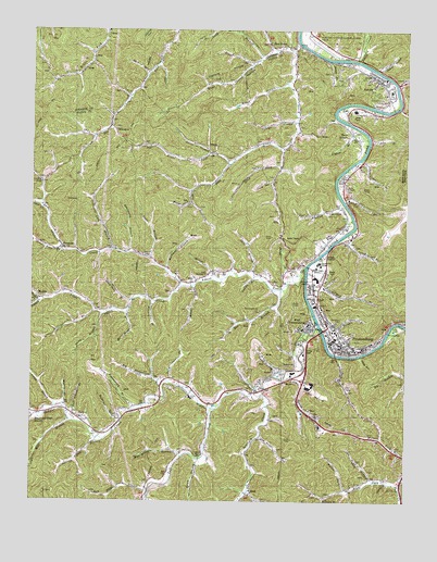
Prestonsburg, KY USGS Topographic Map
Click on map above to begin viewing in our Map Viewer.

This topographic map contains these locations and features:
Feature Name Type Latitude Longitude GNIS ID View Map
Abbott CreekStreamN37.6870°W82.7832°485720View Map
Abbott United Baptist ChurchChurchN37.6922°W82.8655°2097226View Map
Allen BranchStreamN37.6365°W82.8185°485849View Map
Alley ForkStreamN37.7190°W82.7918°485881View Map
Archer ParkParkN37.6657°W82.7838°486019View Map
Arnett BranchStreamN37.6493°W82.8666°486044View Map
AuxierPopulated PlaceN37.7370°W82.7582°486154View Map
Auxier BranchStreamN37.7420°W82.7754°486155View Map
Auxier Census Designated PlaceCensusN37.7356°W82.7662°2629568View Map
Auxier Volunteer Fire DepartmentBuildingN37.7386°W82.7621°2636735View Map
Bays BranchStreamN37.7204°W82.7621°486492View Map
Bays BranchPopulated PlaceN37.7229°W82.7679°507465View Map
Bear HollowValleyN37.7450°W82.7942°486570View Map
Bee ForkStreamN37.7027°W82.8710°486669View Map
Big BranchStreamN37.6812°W82.7907°487118View Map
Blue River BranchStreamN37.6370°W82.8243°487538View Map
Bob Fitzpatrick BranchStreamN37.6562°W82.8304°487601View Map
BonanzaPopulated PlaceN37.6920°W82.8638°507547View Map
Buckhead BranchStreamN37.6262°W82.7768°488259View Map
Bull Creek ChurchChurchN37.6307°W82.7504°488355View Map
Burning Fork Community ChurchChurchN37.7373°W82.8443°2095983View Map
City of PrestonsburgCivilN37.6644°W82.7844°2404571View Map
Clark SchoolSchoolN37.6526°W82.8216°489547View Map
CliffPopulated PlaceN37.6815°W82.7804°489665View Map
Conley ForkStreamN37.7096°W82.8716°489971View Map
Copperas Lick BranchStreamN37.6915°W82.8482°490085View Map
Davidson CemeteryCemeteryN37.6726°W82.7721°490626View Map
Davis BranchStreamN37.7179°W82.8149°490634View Map
DockLocaleN37.6270°W82.8010°490947View Map
DotsonPopulated PlaceN37.6470°W82.8579°507869View Map
Duck Hole BranchStreamN37.6782°W82.8413°491250View Map
East Kentucky Science CenterBuildingN37.6856°W82.7792°2095990View Map
East PointPopulated PlaceN37.7462°W82.7907°491494View Map
Elliott BranchStreamN37.6837°W82.8107°491705View Map
Faith Deliverance TabernacleChurchN37.6643°W82.7985°509932View Map
First Christian ChurchChurchN37.6802°W82.7806°2095995View Map
Fitzpatrick Post OfficePost OfficeN37.6515°W82.8196°2097230View Map
Floyd County Sheriff's OfficeBuildingN37.6681°W82.7716°2767644View Map
Friend BranchStreamN37.6628°W82.7853°492533View Map
Friend ChurchChurchN37.6568°W82.7857°492534View Map
Fryleys BranchStreamN37.7212°W82.7627°492591View Map
George BranchStreamN37.7262°W82.7860°492780View Map
Governors CemeteryCemeteryN37.7334°W82.7596°493058View Map
Granny Fitz BranchStreamN37.6412°W82.8502°493111View Map
Greer BranchStreamN37.7407°W82.8010°493357View Map
Hackworth BranchStreamN37.6909°W82.8429°493519View Map
Hager BranchStreamN37.7364°W82.7888°493538View Map
Hale BranchStreamN37.7387°W82.8357°493548View Map
Highlands Regional Medical CenterHospitalN37.7283°W82.7676°2095988View Map
Holbrook BranchStreamN37.6462°W82.8449°494371View Map
Horn ChapelChurchN37.7087°W82.7702°494557View Map
Hunter BranchStreamN37.7293°W82.7748°2096925View Map
Ike Fitzpatrick BranchStreamN37.6534°W82.7974°494882View Map
Jack Arnett BranchStreamN37.6484°W82.8624°495069View Map
Jane Brown BranchStreamN37.7157°W82.7652°510064View Map
Jim Potter BranchStreamN37.6426°W82.7985°495271View Map
Jim Ward BranchStreamN37.7358°W82.7534°2096922View Map
Jockey HollowValleyN37.7396°W82.7597°495288View Map
Johns CreekStreamN37.7420°W82.7665°495347View Map
Kelse HollowValleyN37.6634°W82.7653°495635View Map
Left Fork Little Paint CreekStreamN37.7145°W82.8085°496236View Map
Left Fork Middle Creek Levisa ForkStreamN37.6495°W82.8143°496241View Map
Lick BranchStreamN37.7045°W82.7704°496429View Map
Little Abbott CreekStreamN37.6819°W82.8247°2509357View Map
Little Paint CreekStreamN37.7459°W82.7852°496820View Map
Long BranchStreamN37.7426°W82.7971°497041View Map
Mart Meade BranchStreamN37.6748°W82.8429°497588View Map
May BranchStreamN37.6793°W82.7824°497699View Map
May CemeteryCemeteryN37.6831°W82.7763°497704View Map
Meade BranchStreamN37.6820°W82.8207°497955View Map
Meadow BranchStreamN37.6784°W82.8349°497971View Map
Middle Creek Levisa ForkStreamN37.6718°W82.7790°498108View Map
Middle Creek Volunteer Fire DepartmentBuildingN37.6424°W82.8514°2637401View Map
Mill BranchStreamN37.6462°W82.8616°498226View Map
Mountain Arts CenterBuildingN37.6563°W82.7929°2095997View Map
Mullin BranchStreamN37.6490°W82.8627°499085View Map
Music CemeteryCemeteryN37.7494°W82.7842°2092804View Map
Music ForkStreamN37.7045°W82.8216°499134View Map
Neely BranchStreamN37.6743°W82.8513°499228View Map
Osborn BranchStreamN37.6848°W82.7999°500005View Map
Paintsville-Prestonsburg-Combs FieldAirportN37.7463°W82.7787°517465View Map
Pin HollowValleyN37.6559°W82.7837°500656View Map
Porter CemeteryCemeteryN37.6826°W82.7795°501145View Map
Potts BranchStreamN37.6898°W82.8374°501210View Map
Prater ForkStreamN37.6784°W82.8721°501279View Map
Prestonburg Community CollegeSchoolN37.6868°W82.7700°2095989View Map
Prestonburg Community College Campbell HallBuildingN37.6870°W82.7787°2095992View Map
Prestonburg Community College Student CenterBuildingN37.6869°W82.7793°2095991View Map
PrestonsburgPopulated PlaceN37.6657°W82.7715°501307View Map
Prestonsburg City Fire DepartmentBuildingN37.6693°W82.7735°2636672View Map
Prestonsburg DivisionCivilN37.6769°W82.7626°1937209View Map
Prestonsburg Fire Department Station 2BuildingN37.6689°W82.7575°2637418View Map
Prestonsburg Police DepartmentBuildingN37.6692°W82.7738°2767473View Map
Pruitt Memorial ChurchChurchN37.6851°W82.8154°501394View Map
Puckett ForkStreamN37.6787°W82.8718°501414View Map
Right Fork Bull CreekStreamN37.6293°W82.7515°501872View Map
Right Fork Little Paint CreekStreamN37.7145°W82.8085°501903View Map
Road BranchStreamN37.7296°W82.7527°2097231View Map
Rough and Tough BranchStreamN37.6468°W82.8721°502373View Map
Saint James Episcopal ChurchChurchN37.6856°W82.8145°2095996View Map
Sally Stevens BranchStreamN37.6590°W82.7896°502810View Map
Sally Stout BranchStreamN37.6562°W82.8285°502811View Map
Sam Hale BranchStreamN37.6279°W82.8352°502875View Map
Shop BranchStreamN37.6304°W82.7602°503420View Map
Short BranchStreamN37.6862°W82.8004°503436View Map
Shot Gun HollowStreamN37.7306°W82.7616°2096924View Map
Spradlin BranchStreamN37.6970°W82.7679°504094View Map
Spradlin Branch SchoolSchoolN37.6940°W82.7690°510170View Map
Spurlock CreekStreamN37.6529°W82.7977°504192View Map
State Road ForkStreamN37.6924°W82.8644°504282View Map
Stephens BranchStreamN37.6998°W82.7679°504332View Map
Steve Fitzpatrick BranchStreamN37.6504°W82.8374°504356View Map
Stumbo HollowValleyN37.6547°W82.8001°2097229View Map
The Bible Fellowship ChurchChurchN37.6579°W82.7715°505112View Map
The Father House ChurchChurchN37.6757°W82.7982°509933View Map
Tom Moore Memorial Baptist ChurchChurchN37.7032°W82.7713°489667View Map
Town BranchStreamN37.6629°W82.7710°509935View Map
Town Branch ChurchChurchN37.6576°W82.7713°509934View Map
Travis HollowValleyN37.7099°W82.7947°505480View Map
Trimble BranchStreamN37.6701°W82.7774°505495View Map
Van Burenvaughn CemeteryCemeteryN37.7016°W82.7835°2097227View Map
Van Burenvaughn CemeteryCemeteryN37.7013°W82.7839°2097228View Map
Wallen ForkStreamN37.6282°W82.7693°506148View Map
WDOC-AM (Prestonsburg)TowerN37.6862°W82.7782°517890View Map
West PrestonsburgPopulated PlaceN37.6712°W82.7818°506470View Map
West Prestonsburg Post OfficePost OfficeN37.6719°W82.7816°2097225View Map
WhitakerPopulated PlaceN37.7234°W82.8468°509354View Map
William BranchStreamN37.6757°W82.8532°506779View Map
Workman BranchStreamN37.6865°W82.8302°507147View Map
WPRT-AM (Prestonsburg)TowerN37.6707°W82.7538°517892View Map
WQHY-FM (Prestonsburg)TowerN37.6957°W82.7849°518011View Map
WQHY-FM (Prestonsburg)TowerN37.6959°W82.7565°518012View Map
WXKZ-FM (Prestonsburg)TowerN37.6568°W82.7660°518013View Map

Note: Coordinates in the location and feature list above are referenced to NAD83 datum.


Copyright (C) 2008-2024 Ryan Niemi / Sunset Dynamics ... All Rights Reserved