TopoQuest Logo
Do you find TopoQuest useful?
Help keep TopoQuest running and adding new maps/features by donating!
Bitcoin:  19c7KJd3qBynnjoSw5npx9KScwjBe4ifkT
Litecoin:  LXs6TkuXGGXo1vDsWCkWVdjQX94eUKd6ui
Home View Maps Find Maps Find Places Resources & Links


Phillips, Maine Topographic Map

USGS Map Title: Phillips, ME
USGS Map MRC: 44070G3
DRG (GeoTIFF) Download: o44070g3.tif


Neighboring USGS Topographic Map Quads:


  Redington, ME  
44070H4
 

  Mount Abraham, ME  
44070H3
 

  Kingfield, ME  
44070H2
 

  Madrid, ME  
44070G4
 

  Phillips, ME  
44070G3
 

  Strong, ME  
44070G2
 

  Weld, ME  
44070F4
 

  Mount Blue, ME  
44070F3
 

  Farmington, ME  
44070F2


Map MRC Location:

N45°
W71°
N45°
W70°
H8 H7 H6 H5 H4 H3 H2 H1
G8 G7 G6 G5 G4 G3 G2 G1
F8 F7 F6 F5 F4 F3 F2 F1
E8 E7 E6 E5 E4 E3 E2 E1
D8 D7 D6 D5 D4 D3 D2 D1
C8 C7 C6 C5 C4 C3 C2 C1
B8 B7 B6 B5 B4 B3 B2 B1
A8 A7 A6 A5 A4 A3 A2 A1
N44°
W71°
N44°
W70°

Phillips, ME USGS 1:24K Topographic Map Preview:
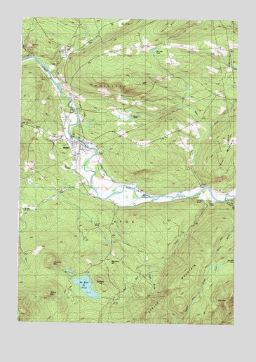
Phillips, ME USGS Topographic Map
Click on map above to begin viewing in our Map Viewer.

This topographic map contains these locations and features:
Feature Name Type Latitude Longitude GNIS ID View Map
AvonPopulated PlaceN44.8062°W70.2712°579112View Map
Avon CemeteryCemeteryN44.8273°W70.2926°1908266View Map
Avon CornerPopulated PlaceN44.8003°W70.2656°579113View Map
Avon Valley Road CemeteryCemeteryN44.8024°W70.3528°2736270View Map
Avon Valley SchoolSchoolN44.7956°W70.3734°561370View Map
Bean MountainSummitN44.8186°W70.2601°561790View Map
Beaver PondLakeN44.8334°W70.3162°561943View Map
Brackley CemeteryCemeteryN44.8729°W70.2594°2724981View Map
Craig SchoolSchoolN44.8623°W70.2559°564449View Map
Cushman SchoolSchoolN44.8573°W70.2881°564704View Map
Day MountainSummitN44.7605°W70.2531°564838View Map
Day Mountain CemeteryCemeteryN44.7794°W70.2540°2736282View Map
Dickey BrookStreamN44.8009°W70.2565°565093View Map
Evergreen CemeteryCemeteryN44.8223°W70.3433°1908320View Map
Knott Burial PlotCemeteryN44.8036°W70.3351°2736294View Map
Lindbergh AirportAirportN44.8147°W70.3444°582206View Map
Mile Square SchoolSchoolN44.8289°W70.2848°571286View Map
Mount Blue CemeteryCemeteryN44.7762°W70.3242°2736299View Map
Mount Blue PondLakeN44.7649°W70.3352°571755View Map
Mount Blue StreamStreamN44.8039°W70.2701°571757View Map
Northstar Emergency Medical Services Phillips StationBuildingN44.8335°W70.3497°2666752View Map
Pease CemeteryCemeteryN44.7993°W70.3061°2725102View Map
PhillipsPopulated PlaceN44.8231°W70.3395°573264View Map
Phillips - Maine CemeteryCemeteryN44.8219°W70.3430°1908397View Map
Phillips Elementary SchoolSchoolN44.8284°W70.3576°1908395View Map
Phillips Historical SocietyBuildingN44.8328°W70.3403°1908392View Map
Phillips MountainSummitN44.7618°W70.3575°573269View Map
Phillips Post OfficePost OfficeN44.8192°W70.3429°1908394View Map
Phillips Public LibraryBuildingN44.8239°W70.3442°1908396View Map
Phillips Volunteer Fire DepartmentBuildingN44.8333°W70.3497°2553115View Map
Riverside CemeteryCemeteryN44.8254°W70.3434°1908416View Map
Sampson HillSummitN44.7750°W70.3223°574807View Map
Sand Hill CemeteryCemeteryN44.8627°W70.3491°2736309View Map
Sprague Howland CemeteryCemeteryN44.8042°W70.3053°2736311View Map
Sylvester HillSummitN44.7682°W70.3274°576626View Map
Tantrattle MountainSummitN44.7739°W70.3557°576652View Map
Tory HillSummitN44.8715°W70.2916°577214View Map
Tory Hill CemeteryCemeteryN44.8633°W70.3085°2725168View Map
Tory Hill PondLakeN44.8621°W70.2980°577215View Map
Town of AvonCivilN44.7813°W70.3128°582336View Map
Trask BrookStreamN44.7737°W70.3009°577279View Map
Union ChurchChurchN44.8237°W70.3381°1908453View Map
Whitney CemeteryCemeteryN44.8428°W70.3464°2736616View Map

Note: Coordinates in the location and feature list above are referenced to NAD83 datum.


Copyright (C) 2008-2024 Ryan Niemi / Sunset Dynamics ... All Rights Reserved