TopoQuest Logo
Do you find TopoQuest useful?
Help keep TopoQuest running and adding new maps/features by donating!
Bitcoin:  19c7KJd3qBynnjoSw5npx9KScwjBe4ifkT
Litecoin:  LXs6TkuXGGXo1vDsWCkWVdjQX94eUKd6ui
Home View Maps Find Maps Find Places Resources & Links


Bennett, Iowa Topographic Map

USGS Map Title: Bennett, IA
USGS Map MRC: 41090F8
DRG (GeoTIFF) Download: o41090f8.tif


Neighboring USGS Topographic Map Quads:


  Tipton East, IA  
41091G1
 

  Lowden, IA  
41090G8
 

  Wheatland, IA  
41090G7
 

  Lime City, IA  
41091F1
 

  Bennett, IA  
41090F8
 

  Dixon, IA  
41090F7
 

  Wilton, IA  
41091E1
 

  Durant, IA  
41090E8
 

  Walcott, IA  
41090E7


Map MRC Location:

N42°
W91°
N42°
W90°
H8 H7 H6 H5 H4 H3 H2 H1
G8 G7 G6 G5 G4 G3 G2 G1
F8 F7 F6 F5 F4 F3 F2 F1
E8 E7 E6 E5 E4 E3 E2 E1
D8 D7 D6 D5 D4 D3 D2 D1
C8 C7 C6 C5 C4 C3 C2 C1
B8 B7 B6 B5 B4 B3 B2 B1
A8 A7 A6 A5 A4 A3 A2 A1
N41°
W91°
N41°
W90°

Bennett, IA USGS 1:24K Topographic Map Preview:
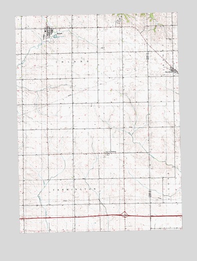
Bennett, IA USGS Topographic Map
Click on map above to begin viewing in our Map Viewer.

This topographic map contains these locations and features:
Feature Name Type Latitude Longitude GNIS ID View Map
BennettPopulated PlaceN41.7403°W90.9738°454511View Map
Bennett (historical)LocaleN41.7403°W90.9738°2001656View Map
Bennett Ambulance ServiceBuildingN41.7389°W90.9737°2599769View Map
Bennett Community SchoolSchoolN41.7407°W90.9769°2001663View Map
Bennett Fire DepartmentBuildingN41.7394°W90.9737°2001662View Map
Bennett LibraryBuildingN41.7395°W90.9738°2001661View Map
Bennett ParkParkN41.7445°W90.9196°2001701View Map
Bennett Police DepartmentBuildingN41.7395°W90.9738°2001660View Map
Bennett Post OfficePost OfficeN41.7422°W90.9738°2001657View Map
City of BennettCivilN41.7398°W90.9738°2394135View Map
City of New LibertyCivilN41.7160°W90.8780°2395202View Map
Farmington CemeteryCemeteryN41.6778°W90.9863°2001700View Map
Interchange 277CrossingN41.6339°W90.9188°2001706View Map
New LibertyPopulated PlaceN41.7178°W90.8790°459479View Map
New Liberty (historical)LocaleN41.7178°W90.8790°2046487View Map
New Liberty CemeteryCemeteryN41.7344°W90.8796°2046590View Map
New Liberty City HallBuildingN41.7178°W90.8790°2046490View Map
New Liberty Fire DepartmentBuildingN41.7189°W90.8797°2577183View Map
New Liberty LibraryBuildingN41.7178°W90.8790°2046489View Map
New Liberty Post OfficePost OfficeN41.7178°W90.8790°2046488View Map
Peace Church of Christ UnitedChurchN41.7414°W90.9727°2001658View Map
Saint Paul Lutheran ChurchChurchN41.7414°W90.9715°2001659View Map
School Number 4 (historical)SchoolN41.6409°W90.8888°465160View Map
SunburyPopulated PlaceN41.6700°W90.9310°462084View Map
Sunbury (historical)LocaleN41.6700°W90.9310°2001554View Map
Sunbury Post Office (historical)Post OfficeN41.6700°W90.9310°2001553View Map
Sunbury School (historical)SchoolN41.6697°W90.9188°465171View Map
Township of FarmingtonCivilN41.6408°W90.9578°467824View Map
Township of InlandCivilN41.7280°W90.9572°468075View Map

Note: Coordinates in the location and feature list above are referenced to NAD83 datum.


Copyright (C) 2008-2024 Ryan Niemi / Sunset Dynamics ... All Rights Reserved