TopoQuest Logo
Do you find TopoQuest useful?
Help keep TopoQuest running and adding new maps/features by donating!
Bitcoin:  19c7KJd3qBynnjoSw5npx9KScwjBe4ifkT
Litecoin:  LXs6TkuXGGXo1vDsWCkWVdjQX94eUKd6ui
Home View Maps Find Maps Find Places Resources & Links


Bellmore, Indiana Topographic Map

USGS Map Title: Bellmore, IN
USGS Map MRC: 39087G1
DRG (GeoTIFF) Download: o39087g1.tif


Neighboring USGS Topographic Map Quads:


  Wallace, IN  
39087H2
 

  Alamo, IN  
39087H1
 

  New Market, IN  
39086H8
 

  Rockville, IN  
39087G2
 

  Bellmore, IN  
39087G1
 

  Russellville, IN  
39086G8
 

  Catlin, IN  
39087F2
 

  Mansfield, IN  
39087F1
 

  Clinton Falls, IN  
39086F8


Map MRC Location:

N40°
W88°
N40°
W87°
H8 H7 H6 H5 H4 H3 H2 H1
G8 G7 G6 G5 G4 G3 G2 G1
F8 F7 F6 F5 F4 F3 F2 F1
E8 E7 E6 E5 E4 E3 E2 E1
D8 D7 D6 D5 D4 D3 D2 D1
C8 C7 C6 C5 C4 C3 C2 C1
B8 B7 B6 B5 B4 B3 B2 B1
A8 A7 A6 A5 A4 A3 A2 A1
N39°
W88°
N39°
W87°

Bellmore, IN USGS 1:24K Topographic Map Preview:
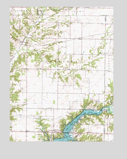
Bellmore, IN USGS Topographic Map
Click on map above to begin viewing in our Map Viewer.

This topographic map contains these locations and features:
Feature Name Type Latitude Longitude GNIS ID View Map
Bains BranchStreamN39.7534°W87.0556°448341View Map
BellmorePopulated PlaceN39.7592°W87.1053°430781View Map
Bellmore Fire DepartmentBuildingN39.7593°W87.1045°2701357View Map
Bellmore Volunteer Fire DepartmentBuildingN39.7593°W87.1045°2625908View Map
Black CemeteryCemeteryN39.8064°W87.0333°431121View Map
Bruin CemeteryCemeteryN39.8404°W87.1047°431658View Map
Burton CemeteryCemeteryN39.7666°W87.0895°431881View Map
Byrd BranchStreamN39.7825°W87.0039°431923View Map
C Moore LakeLakeN39.8702°W87.0866°431930View Map
Clodfelter CemeteryCemeteryN39.8324°W87.0151°432682View Map
Demeree CreekStreamN39.8737°W87.0847°433463View Map
Dooley Station (historical)LocaleN39.8603°W87.0942°452152View Map
GuionPopulated PlaceN39.8428°W87.1114°435552View Map
HollandsburgPopulated PlaceN39.7603°W87.0722°449670View Map
Jarvis Smith CemeteryCemeteryN39.8569°W87.0545°436942View Map
Lane CemeteryCemeteryN39.7860°W87.1060°437611View Map
Little Raccoon Structure Number 11DamN39.8500°W87.0850°447614View Map
Lough CemeteryCemeteryN39.8723°W87.1210°438341View Map
MilliganPopulated PlaceN39.8456°W87.0383°439238View Map
Mount Moriah CemeteryCemeteryN39.7790°W87.0747°439605View Map
Needmore (historical)LocaleN39.8167°W87.0642°452149View Map
ParkevillePopulated PlaceN39.8170°W87.0845°452153View Map
Parkville ChurchChurchN39.8175°W87.0870°440905View Map
Philadelphia CemeteryCemeteryN39.8239°W87.0523°441078View Map
Pisgah CemeteryCemeteryN39.8014°W87.0055°441191View Map
Portland MillsPopulated PlaceN39.7781°W87.0092°441473View Map
Portland Mills BridgeBridgeN39.8606°W87.0861°1789054View Map
Portland Mills ChurchChurchN39.7867°W87.0208°441474View Map
Raccoon CemeteryCemeteryN39.8311°W87.0864°441716View Map
Seybold CemeteryCemeteryN39.8351°W87.0952°443232View Map
South Fork Little Raccoon CreekStreamN39.8359°W87.1106°443808View Map
Spencer CemeteryCemeteryN39.8509°W87.0631°443937View Map
Thomas CemeteryCemeteryN39.7582°W87.0300°444688View Map
Township of GreeneCivilN39.8237°W87.0659°453350View Map
Waveland Conservation ClubLocaleN39.8681°W87.0870°452410View Map

Note: Coordinates in the location and feature list above are referenced to NAD83 datum.


Copyright (C) 2008-2024 Ryan Niemi / Sunset Dynamics ... All Rights Reserved