TopoQuest Logo
Do you find TopoQuest useful?
Help keep TopoQuest running and adding new maps/features by donating!
Bitcoin:  19c7KJd3qBynnjoSw5npx9KScwjBe4ifkT
Litecoin:  LXs6TkuXGGXo1vDsWCkWVdjQX94eUKd6ui
Home View Maps Find Maps Find Places Resources & Links


Catlin, Indiana Topographic Map

USGS Map Title: Catlin, IN
USGS Map MRC: 39087F2
DRG (GeoTIFF) Download: o39087f2.tif


Neighboring USGS Topographic Map Quads:


  Montezuma, IN  
39087G3
 

  Rockville, IN  
39087G2
 

  Bellmore, IN  
39087G1
 

  Mecca, IN  
39087F3
 

  Catlin, IN  
39087F2
 

  Mansfield, IN  
39087F1
 

  Rosedale, IN  
39087E3
 

  Brazil West, IN  
39087E2
 

  Brazil East, IN  
39087E1


Map MRC Location:

N40°
W88°
N40°
W87°
H8 H7 H6 H5 H4 H3 H2 H1
G8 G7 G6 G5 G4 G3 G2 G1
F8 F7 F6 F5 F4 F3 F2 F1
E8 E7 E6 E5 E4 E3 E2 E1
D8 D7 D6 D5 D4 D3 D2 D1
C8 C7 C6 C5 C4 C3 C2 C1
B8 B7 B6 B5 B4 B3 B2 B1
A8 A7 A6 A5 A4 A3 A2 A1
N39°
W88°
N39°
W87°

Catlin, IN USGS 1:24K Topographic Map Preview:
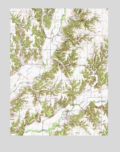
Catlin, IN USGS Topographic Map
Click on map above to begin viewing in our Map Viewer.

This topographic map contains these locations and features:
Feature Name Type Latitude Longitude GNIS ID View Map
Adams Lee CemeteryCemeteryN39.6455°W87.2486°430005View Map
Aitken Lake DamDamN39.6534°W87.1833°448820View Map
BridgetonPopulated PlaceN39.6450°W87.1775°431520View Map
Bridgeton BridgeBridgeN39.6498°W87.1764°1789062View Map
Bridgeton Elementary and Junior High SchoolSchoolN39.6434°W87.1792°447188View Map
Bridgeton Fire DepartmentBuildingN39.6484°W87.1736°2701358View Map
Bridgeton Volunteer Fire DepartmentBuildingN39.6484°W87.1736°2625782View Map
Brunot CemeteryCemeteryN39.6351°W87.2322°431670View Map
Butler FieldAirportN39.7397°W87.2232°449327View Map
Case LakeReservoirN39.6545°W87.1833°448819View Map
CatlinPopulated PlaceN39.6937°W87.2353°432242View Map
Clear RunStreamN39.6425°W87.1853°432630View Map
Clear Run CemeteryCemeteryN39.6412°W87.1809°432631View Map
Conleys Ford Covered BridgeBridgeN39.6592°W87.1331°446555View Map
Crooks Covered BridgeBridgeN39.7245°W87.1897°446556View Map
Ferguson BranchStreamN39.6498°W87.1781°434452View Map
Ford RunStreamN39.6275°W87.1992°434640View Map
Happy HollowValleyN39.6873°W87.1431°435711View Map
Hartman Family CemeteryCemeteryN39.6416°W87.2183°435835View Map
Hatfield CemeteryCemeteryN39.7204°W87.1453°435873View Map
Hopper BranchStreamN39.6770°W87.2267°449064View Map
Jeffries Ford BridgeBridgeN39.6300°W87.2083°436981View Map
Jeffries RunStreamN39.6414°W87.1992°436982View Map
Lakeland (historical)LocaleN39.7317°W87.1306°452212View Map
Lakeys BranchStreamN39.7009°W87.1986°449065View Map
Leatherwood BranchStreamN39.7389°W87.1836°437707View Map
Little Raccoon Structure Number 16DamN39.7400°W87.1700°447609View Map
McAllisters Covered BridgeBridgeN39.7098°W87.1914°446825View Map
MinshallPopulated PlaceN39.6717°W87.2217°439274View Map
Molasses CreekStreamN39.7203°W87.1970°439315View Map
Mount Olivet ChurchChurchN39.6884°W87.2411°439632View Map
Neet Covered BridgeBridgeN39.7020°W87.1978°446826View Map
Nevins Covered BridgeBridgeN39.6848°W87.2125°446827View Map
New DiscoveryPopulated PlaceN39.7317°W87.1306°452211View Map
New Discovery ChurchChurchN39.7234°W87.1508°440040View Map
PiattsvillePopulated PlaceN39.7045°W87.1258°452210View Map
Pleasant ValleyValleyN39.6492°W87.1758°441319View Map
Pleasant Valley ChurchChurchN39.6687°W87.1511°441328View Map
SmockvillePopulated PlaceN39.6262°W87.1331°443711View Map
Snow HillPopulated PlaceN39.6556°W87.1700°449844View Map
Strange BranchStreamN39.6550°W87.1617°444259View Map
Sunderland BranchStreamN39.6773°W87.2336°444407View Map
SuperiorPopulated PlaceN39.6295°W87.1556°452208View Map
Township of AdamsCivilN39.7401°W87.2093°453080View Map
Township of RaccoonCivilN39.6507°W87.1807°453778View Map
Walton (historical)Populated PlaceN39.6681°W87.1500°452209View Map
Williams CreekStreamN39.7200°W87.1956°446073View Map
Zellors PondLakeN39.6273°W87.1355°446430View Map

Note: Coordinates in the location and feature list above are referenced to NAD83 datum.


Copyright (C) 2008-2024 Ryan Niemi / Sunset Dynamics ... All Rights Reserved